
Créé par Emilie, le 20 juin 2026
Votre guide Ryo
GR20: Discovering Corsica's Legendary Hiking Trail
© Shutterstock
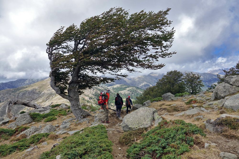
Crossing Corsica from northwest to southeast, the GR20 is considered one of the most difficult long-distance hiking trails in Europe. Approximately 180 kilometers long with nearly 10,000 meters of cumulative positive elevation gain, this legendary route attracts thousands of hikers each year seeking challenges and breathtaking landscapes. Between steep mountains, glacial lakes and mountain huts, the GR20 promises an unforgettable adventure in the heart of the Isle of Beauty.
What is the GR20?
The GR20, also called Fra li Monti ("across the mountains" in Corsican), is a long-distance hiking trail that winds through the central mountain range of Corsica. Recognizable by its characteristic white and red GR markings, this route traditionally connects Calenzana in the northwest to Conca in the southeast, although it can be hiked in both directions.
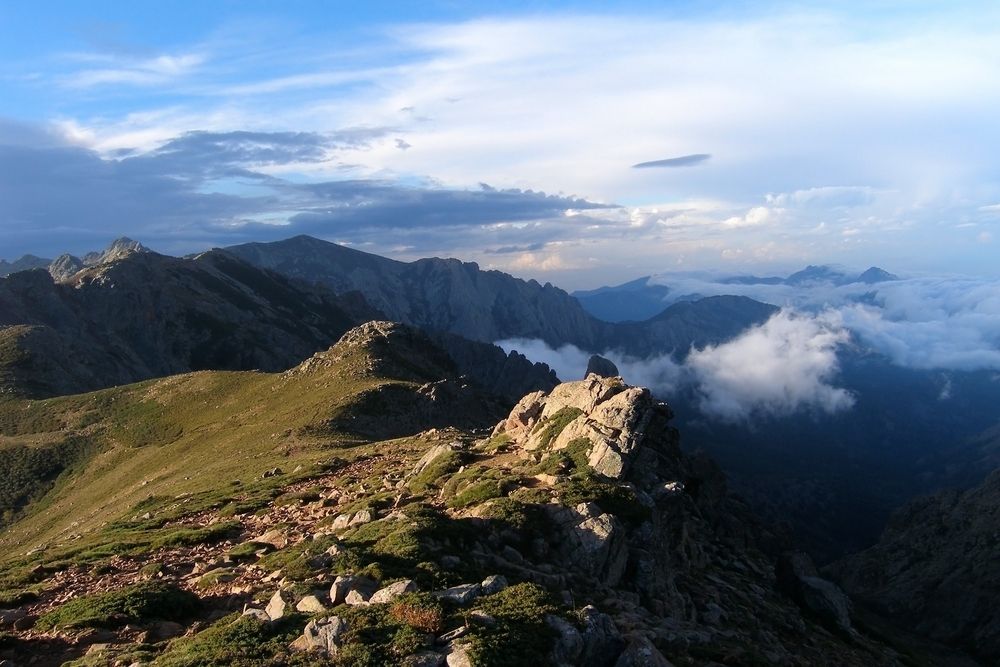
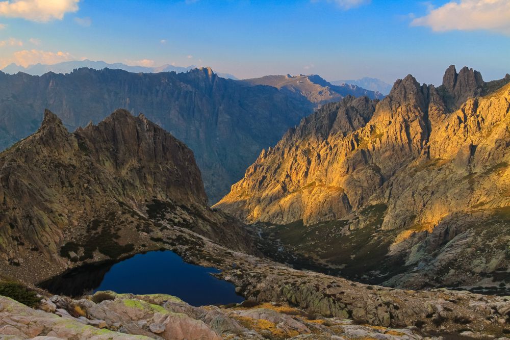
Created in the 1970s, the GR20 crosses landscapes of striking beauty: rocky ridges, Laricio pine forests, high-altitude lakes, glacial cirques and deep valleys. The trail crosses several emblematic peaks of Corsica, including Monte Cinto (2706 m), the island's highest point, and offers exceptional panoramas over the Mediterranean.
With its 180 kilometers and its 10,000 meters of positive elevation gain, the GR20 requires excellent physical condition and mountain hiking experience. Its reputation as Europe's most difficult trail is well-deserved: rocky and rugged terrain, exposed passages, significant elevation gains and changing weather conditions are integral parts of the adventure.
The Two Sections of the GR20
The GR20 trail naturally divides into two distinct sections, each presenting its own characteristics and difficulty levels.
1. GR20 North: from Calenzana to Vizzavona
Considered the most difficult and spectacular section, the northern section of the GR20 starts in Calenzana, a small Balagne village located near Calvi. It ends in Vizzavona, a village-stop accessible by train in the heart of Corsica.
This first half is characterized by technical and rocky trails, exposed passages with chains, and significant elevation gains. Hikers discover breathtaking mineral landscapes, notably the famous Cirque de la Solitude (now closed, with an alpine variant proposed), rocky ridges and the needles of Bavella. The GR20 North requires good mastery of progression on mountainous terrain and absence of vertigo for certain exposed passages.
2. GR20 South: from Vizzavona to Conca
The southern section, while still demanding, is generally considered less technical but equally beautiful. It leads hikers from Vizzavona to the village of Conca, gateway to Porto-Vecchio and the southeast coast of the island.
The GR20 South offers more varied landscapes with dense forests, vast plateaus like that of Coscione, and panoramic views over the Gulf of Porto-Vecchio. The trails are less rocky, but the stages remain long and the elevation gain sustained. This section allows you to better enjoy Corsican fauna and flora, with the possibility of observing wild horses and mouflon.
The 16 Stages of the GR20
The classic GR20 route is divided into 16 stages, achievable in as many days for hikers at a moderate pace. Some experienced athletes double the stages to complete the trek in 7 to 10 days, while others prefer to take their time and split certain particularly demanding days.
GR20 North Stages (from Calenzana to Vizzavona)
1. Calenzana – Refuge d'Ortu di u Piobbu
Distance: 12 km | Elevation gain: 1,470 m | Duration: 6h
First legendary and difficult stage that immediately sets the tone with a sustained climb to the refuge located at 1,570 m altitude.
2. Refuge d'Ortu di u Piobbu – Refuge de Carrozzu
Distance: 7 km | Elevation gain: 680 m | Duration: 5h30
Technical stage with rocky passages and chains, offering spectacular views over the Filosorma valley.
3. Refuge de Carrozzu – Refuge d'Asco Stagnu (Haut-Asco)
Distance: 6 km | Elevation gain: 790 m | Duration: 5h
Demanding route with possibility of climbing Monte Cinto (2,706 m), Corsica's highest peak.
4. Refuge d'Asco Stagnu – Refuge de Tighjettu
Distance: 6.5 km | Elevation gain: 840 m | Duration: 4h30
Short but intense stage, crossing the Col de Perdu and offering grandiose panoramas.
5. Refuge de Tighjettu – Refuge de Ciottulu di i Mori
Distance: 6 km | Elevation gain: 580 m | Duration: 4h
Crossing the plateau of the same name with possibility of ascending Paglia Orba (2,525 m).
6. Refuge de Ciottulu di i Mori – Refuge de Manganu
Distance: 8 km | Elevation gain: 640 m | Duration: 7h30
Long and magnificent stage passing by Lake Nino, a glacial jewel surrounded by green meadows.
7. Refuge de Manganu – Refuge de Petra Piana
Distance: 8 km | Elevation gain: 760 m | Duration: 6h
Passage by lakes Melo and Capitello, two high-altitude lakes set in a rocky cirque.
8. Refuge de Petra Piana – Refuge de l'Onda
Distance: 7.5 km | Elevation gain: 490 m | Duration: 5h
Relatively short stage with descent towards the Grottaccia sheepfold.
9. Refuge de l'Onda – Vizzavona
Distance: 14 km | Elevation gain: 710 m | Duration: 6h30
Last stage of the northern section, gradually descending to the village-stop of Vizzavona, accessible by train.
GR20 South Stages (from Vizzavona to Conca)
10. Vizzavona – Bergeries de Capanelle
Distance: 15 km | Elevation gain: 890 m | Duration: 5h30
Resumption through forest with a gradual climb to the sheepfolds.
11. Bergeries de Capanelle – Refuge de Prati
Distance: 8 km | Elevation gain: 640 m | Duration: 6h
Stage crossing Monte Renoso with possibility of swimming in the glacial lake of Bastani.
12. Refuge de Prati – Refuge d'Usciolu
Distance: 10 km | Elevation gain: 680 m | Duration: 6h
Crossing varied landscapes between forests and rocky ridges.
13. Refuge d'Usciolu – Refuge d'Asinau
Distance: 12 km | Elevation gain: 845 m | Duration: 8h
Longest stage of the GR20 South, passing through the Coscione plateau and Monte Incudine (2,134 m).
14. Refuge d'Asinau – Refuge de Paliri
Distance: 14 km | Elevation gain: 430 m | Duration: 7h
Gradual descent with view of the famous Aiguilles de Bavella, spectacular rock formations.
15. Refuge de Paliri – Conca
Distance: 12 km | Elevation gain: 160 m | Duration: 5h
Last stage in continuous descent to the village of Conca, marking the triumphant end of the GR20.
When to Hike the GR20?
Choosing the right period is crucial for a successful GR20. The best window for hiking the trail extends from late June to early September, when most refuges are open and staffed.
June: Ideal period for those seeking tranquility. Trails are less crowded, temperatures still cool and pleasant. However, beware of persistent snow patches at altitude, particularly in the northern section. Good mastery of snow progression techniques may be necessary.
July-August: High season on the GR20, with heavy crowds in refuges. Temperatures are high, making climbs particularly exhausting in midday. The advantage: generally stable weather conditions and all services operational. Refuge reservations essential several months in advance.
September: Excellent compromise between favorable weather conditions and moderate crowds. Temperatures become more mild again, light is magnificent for photographers, and atmosphere in refuges more relaxed. Period particularly recommended for a first GR20.
To avoid: From October to May, the GR20 becomes a very technical winter route, reserved for experienced mountaineers equipped accordingly. Refuges are closed, snow covers a large part of the route, and weather conditions become unpredictable and dangerous.
Difficulty Level and Physical Preparation
The GR20 is not a classic hiking trail. Its reputation as Europe's most difficult trail requires serious preparation, both physical and mental.
What Level is Required?
An excellent physical condition is essential. You must be able to walk 6 to 8 hours per day with a 10 to 15 kg backpack, on rugged terrain with significant elevation gains. Prior experience of mountain hiking is strongly recommended, particularly to handle rocky passages, chains and snow crossings.
The GR20 does not require mountaineering skills per se, but demands good ease on rocky terrain, absence of vertigo on certain exposed passages, and the ability to move autonomously in the mountains. Progression on rocks and use of chains are integral parts of the route, particularly in the northern section.
How to Prepare Physically?
Ideally, start your preparation 8 to 12 weeks before departure. Typical program:
- Training hikes: Multiply mountain outings, gradually increasing distance and elevation gain. Aim for 2 to 3 hikes per week of 4 to 6 hours, with weighted pack.
- Muscle strengthening: Work particularly the legs (quadriceps, calves), back and abdominal core. Stair climbing, squats and core exercises are your best allies.
- Cardio: Running, cycling, swimming: any endurance activity improves your cardio-respiratory capacity, essential at altitude.
- Altitude acclimatization: If possible, do some hikes above 2000 meters before your departure.
Don't forget to integrate recovery weeks into your program: alternate 3 weeks of intensive training with 1 week of relative rest to allow your body to recover.
Accommodation on the GR20
The GR20 has a network of refuges distributed along the route, managed by the Corsica Regional Natural Park (PNRC). These refuges offer basic but appreciated accommodation after a long day of hiking.
PNRC Refuges
Each refuge offers:
- Platform dormitories: Large wooden platforms equipped with mattresses (without blankets). Bring your sleeping bag suitable for cool mountain temperatures.
- Basic sanitary facilities: Dry toilets and drinking water points (usually a spring or fountain nearby).
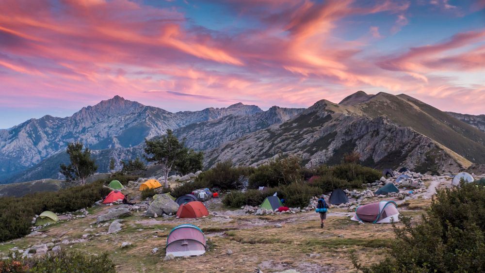
- Bivouac area: Possibility to pitch tent near the refuge (paid pitch, cheaper than dormitory).
- Limited supplies: Sale of basic products (pasta, canned goods, energy bars) at high prices due to helicopter supply.
2024 rates (indicative): about €15 per night in refuge, €7 for bivouac pitch. Mandatory reservation in high season via PNRC website or by phone, several months in advance for July-August.
Sheepfolds and Private Guesthouses
In addition to PNRC refuges, you'll find some renovated sheepfolds and private guesthouses along the route. They generally offer better comfort (sheets provided, hot showers, hearty meals), but at higher prices. It's the ideal option to treat yourself to one or two nights of rest during the trek.
Wild Camping: Regulations
Wild camping is prohibited between refuges to preserve the fragile GR20 environment. You can only pitch your tent at designated spots near refuges. This rule is strictly controlled by refuge wardens and park guards.
Equipment and Gear for the GR20
Appropriate equipment is essential for a successful GR20 in good conditions. Your pack should ideally not exceed 10 to 12 kg (excluding water and food).
Essential Equipment
Backpack: 40-50 liters if sleeping in refuges, 50-60 liters if bivouacking. Choose a model with good back ventilation and an effective waist belt to distribute weight.
Hiking boots: High-top, waterproof and already broken in (blister risk otherwise). Treaded soles mandatory for grip on rocks.
Trekking poles: Very useful for relieving knees on descents and ensuring balance on rough terrain.
Sleeping bag: Comfort temperature 0°C minimum, even in summer. Nights can be cool at altitude.
Technical clothing:
- Breathable technical underwear
- Short and long sleeve t-shirts
- Fleece or softshell for mid-season
- Lightweight down jacket for cool evenings/mornings
- Waterproof and breathable jacket (Gore-Tex or equivalent)
- Lightweight and breathable hiking pants
- Shorts for hot days
- Gaiters (useful early season for snow patches)
Sun and head protection:
- Wide-brimmed hat or cap
- Category 3 or 4 sunglasses
- High protection sunscreen (SPF 50+)
- Protective lip balm
First aid kit: Anti-blister plasters (Compeed), disinfectant, painkillers, elastic bandage, emergency blanket, whistle.
Water and food: Water bottles or hydration bladder (2-3 liters total capacity), water purification tablets, energy food (bars, dried fruits, chocolate).
Navigation: IGN map of GR20 (Top 25), compass, charged phone with offline mapping app (VisoRando, IGNRando).
Miscellaneous: Headlamp with spare batteries, multi-tool knife, lighter, toilet paper and garbage bag, power bank for phone.
If You're Bivouacking
Add: lightweight tent (2 kg maximum for one person), insulating sleeping pad, stove and cookware, freeze-dried or dehydrated food.
Food and Resupply
Food management is a key element of GR20 success. Energy expenditure is considerable: count between 3,500 and 5,000 calories per day depending on your size and effort intensity.
Resupply in refuges: All staffed refuges sell basic products, but at high prices (2 to 3 times normal price) and with limited choice. You'll generally find: pasta, rice, canned goods, cheese, cured meats, fresh bread, energy bars, dried fruits, chocolate.
Village stops: Vizzavona (stage 9) has a grocery store where you can resupply for the second part. Some refuges also offer prepared meals on reservation.
Recommended food strategy:
- Leave with 2-3 days of food from Calenzana
- Supplement at refuges as you go
- Do a major resupply at Vizzavona for the southern section
- Favor lightweight energy foods: dried fruits, nuts, cereal bars, chocolate
- Plan hot meals in the evening to recover: pasta, rice, semolina with protein supplement
Water: Drinking water points at each refuge (springs, fountains). Between refuges, some springs are marked on maps, but check their condition with wardens. Always carry 2 to 3 liters of water, more in hot weather.
Going Solo or with Companions?
The question of going solo or in a group on the GR20 deserves consideration, each option having advantages and disadvantages.
Going Solo
Advantages: Total freedom on pace, breaks, departure times. Possibility to modify your itinerary according to your feeling. Strong introspective experience.
Disadvantages: Reduced safety in case of accident or health problem. Pack weight cannot be shared. Can be psychologically difficult in moments of fatigue.
Advice: The GR20 is busy enough in season that you're never really isolated. Many friendships form in refuges, and it's easy to walk part of the way with other hikers met along the way.
Going with Others
Advantages: Increased safety, moral support in difficult moments, sharing of collective equipment (tent, stove), friendly experience.
Disadvantages: Need to agree on walking pace, risk of tension if physical levels are too different.
Advice: Ensure to form a homogeneous group in terms of physical condition and motivation. Two to four people is the ideal size. Beyond that, logistics become complex (refuge reservations, managing different paces).
With a Guide or Independently?
Many specialized agencies offer guided treks on the GR20, with luggage portage and complete organization. This secure option is particularly suitable for high mountain beginners or those who want to fully enjoy the landscape without worrying about logistics.
Experienced hikers will generally prefer total autonomy, more rewarding and allowing true immersion in the GR20 adventure.
Must-See Points of Interest on the GR20
Beyond athletic performance, the GR20 offers exceptional landscapes and remarkable natural sites that mark the route.
1. The Cirque de la Solitude (closed – alpine variant)
Long considered the most technical passage of the GR20, the Cirque de la Solitude is now officially closed following several fatal accidents. An alpine variant has been developed, more secure but still impressive, with chains and very exposed terrain.
2. Lake Nino
True pearl of the GR20, Lake Nino (1,743 m) is a glacial lake surrounded by pozzines, these wet meadows typical of Corsica where horses and cows graze semi-wild. The contrast between the turquoise water of the lake and the brilliant green of the meadows is striking. A 30-minute detour off-trail from Manganu refuge allows you to reach this magical place.
3. Lakes Melo and Capitello
Accessible during stage 7, these two glacial lakes set in a rocky cirque offer a grandiose spectacle. Lake Melo (1,711 m) is easily reached, while Lake Capitello (1,930 m), higher and wilder, requires additional small scrambling.
4. Monte Cinto
Corsica's highest point at 2,706 meters, Monte Cinto is climbed from Asco Stagnu refuge (stage 3). This off-GR ascent requires 3 to 4 hours round trip and offers absolutely breathtaking 360° panorama over the entire island and Mediterranean.
5. The Coscione Plateau
Vast green expanse at over 1,400 meters altitude, the Coscione plateau offers a radically different landscape from the rest of the GR20. These large high meadows, dotted with pozzines and streams, are the domain of wild horses and Corsican cows.
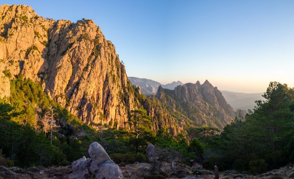
6. The Aiguilles de Bavella
These spectacular rock formations with cathedral-like appearances dominate the end of the GR20 South. Their jagged silhouettes cutting against the sky constitute one of the most photographed panoramas in Corsica. The GR20 passes at the foot of these needles during the penultimate stage.
Variants and Alternatives to the GR20
If the complete GR20 seems too demanding, or if you want to discover Corsica differently, several alternatives are available to you.
Doing Only Part of the GR20
Many hikers choose to walk only one section of the trail, generally the GR20 North (Calenzana-Vizzavona), considered the most spectacular. This option allows discovering the essence of the GR20 in 7 to 9 days.
The Mare a Mare Trails
Corsica offers three Mare a Mare ("sea to sea") itineraries that cross the island from east to west, offering a less technical alternative to the GR20:
- Mare a Mare Nord: From Moriani to Cargèse in 11 days
- Mare a Mare Centre: From Ghisonaccia to Porticcio in 7 days
- Mare a Mare Sud: From Porto-Vecchio to Propriano in 5 days
These trails, less crowded and less physically demanding, allow discovering authentic Corsica by crossing many traditional villages.
The Mare e Monti Trails
The Mare e Monti ("sea to mountain") itineraries combine coast and mountain:
- Mare e Monti Nord: From Calenzana to Cargèse in 10 days
- Mare e Monti Sud: From Porticcio to Propriano in 5 days
These trails offer beautiful landscape diversity with a difficulty level accessible to most.
Safety and Practical Advice
The Corsican mountains don't forgive improvisation. Some essential safety rules for a successful GR20:
Before Departure
- Subscribe to repatriation insurance and check your credit card guarantees
- Inform your relatives of your itinerary and planned dates
- Check weather forecasts and snow conditions
- Verify refuge opening and make your reservations
On the Trail
- Leave early in the morning (6am-7am) to avoid strong heat and afternoon storms
- Respect your pace, don't try to follow faster hikers
- Hydrate regularly (1 liter of water every 2-3 hours)
- If in doubt about the route, ask other hikers or turn back
- Respect markings and don't attempt risky shortcuts
- If you're tired, don't hesitate to split a stage or take a rest day
Emergency Numbers
- 112: European emergency number (works even without your operator's network)
- 18: Fire department
- 15: SAMU
- 04 95 61 13 95: PGHM (High Mountain Gendarmerie Squad) of Corsica
Important: Phone network is irregular on the GR20. Some areas are covered, others not. In emergency, climb to altitude to try to get network signal.
Weather and Natural Risks
Weather in Corsican mountains can change very rapidly. Summer storms are frequent in the afternoon and can be violent. In case of storm:
- Immediately descend from ridges and summits
- Move away from isolated trees and water bodies
- Crouch on your backpack, feet together
- Move away from any metal objects (poles, ice axe)
Rockfall is frequent, particularly after heavy rains. Be vigilant in couloirs and under rock faces.
Environmental Respect
The GR20 crosses the Corsica Regional Natural Park, a protected area of great fragility. Some essential gestures to preserve this exceptional natural heritage:
- Leave no waste: Take everything back (papers, packaging, cigarette butts). Organic waste (peels, cores) takes very long to decompose at altitude.
- Use refuge toilets and avoid relieving yourself in nature. If necessary, move away from trails and water points (minimum 50 meters), dig a hole and cover.
- Don't pick flowers, don't disturb wildlife
- Stay on marked trails to avoid erosion
- Respect quiet zones and tranquility of places
- Save water, precious resource in mountains
- Never light fires: extremely high fire risk in Corsica
The "Leave No Trace" principle should guide each of your actions on the GR20.
Budget for the GR20
Preparing a realistic budget is important to approach your GR20 adventure serenely.
Transport:
- Flight to Corsica: €100-400 depending on season and advance booking
- Airport-Calenzana transfer: €50-80 (taxi or shuttle)
- Conca-airport return: €80-120
Accommodation and meals (for 16 days):
- Nights in refuge: €15 x 15 nights = €225
- OR Bivouac: €7 x 15 nights = €105 + camping equipment
- Food resupply: €15-20/day = €240-320
- Meals in refuges/sheepfolds (occasional): €15-25/meal
Equipment:
If you need to buy everything: count €800-1500 for complete quality equipment (backpack, boots, technical clothing, sleeping bag, etc.). Possibility to rent or borrow gear to reduce costs.
Estimated total:
- Tight budget (bivouac, self-cooking): €800-1000
- Comfortable budget (refuge, some meals): €1200-1500
- Budget with baggage portage and guiding: €2000-3000
Before and After the GR20: Discovering Corsica
Take advantage of your visit to Corsica to explore the treasures of the Isle of Beauty before or after your hike. Ryo offers audio-guided circuits to discover the most beautiful Corsican cities.
Download the audio-guided circuit to discover Ajaccio on foot and independently
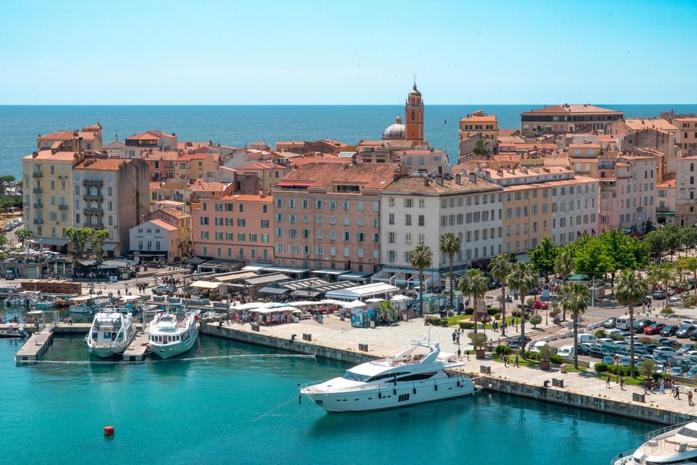
Visit Ajaccio, the imperial city, is the ideal opportunity to immerse yourself in Corsican and Napoleonic history. The capital of southern Corsica seduces with its Mediterranean atmosphere, its colorful old town streets, its lively port and its fine sand beaches. Thanks to the Ryo audio-guided circuit, explore independently the Bonaparte House, the Santa-Maria Assunta cathedral, the citadel and the famous Ajaccio market. The application guides you through 18 points of interest with fun audio guides and captivating historical anecdotes. After the GR20 effort, nothing beats a gourmet break in an Ajaccio restaurant to taste Corsican specialties: cured meats, cheeses, veal with olives and fiadone. Don't forget to detour by the Sanguinaires islands, accessible by boat from Ajaccio port, to admire an unforgettable sunset over the Mediterranean.
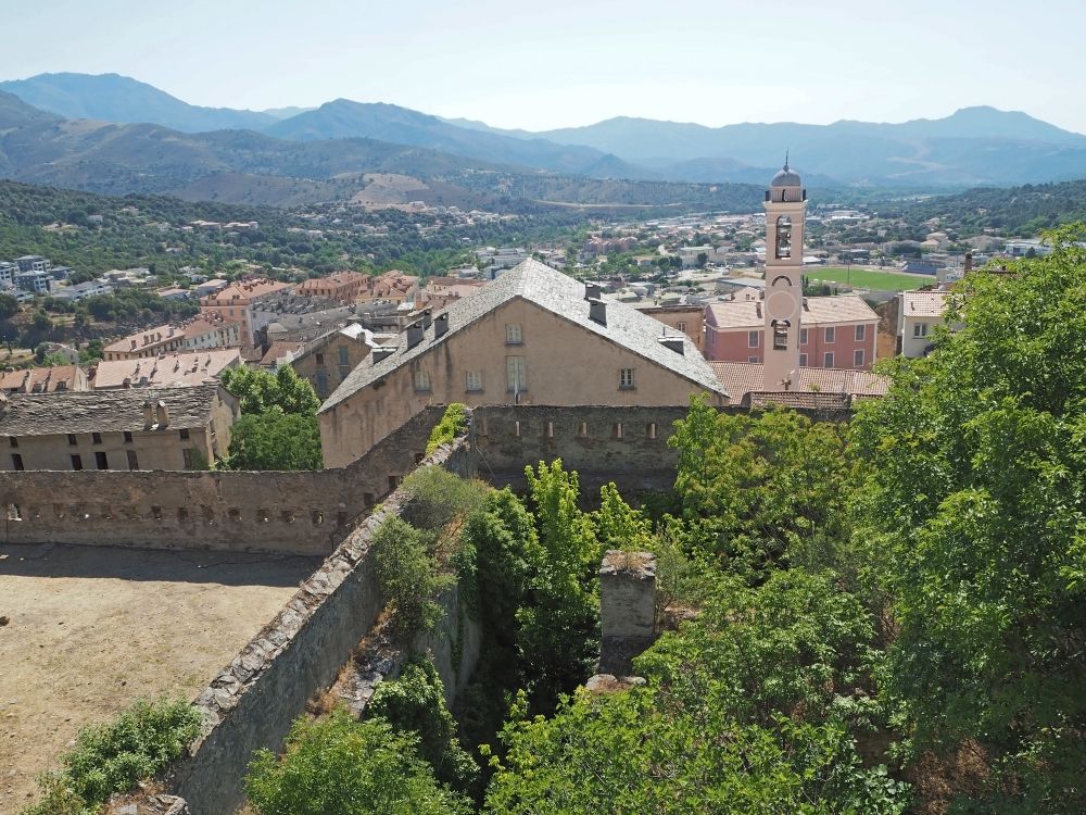
In the north of the island, Visit Bastia immerses you in Corsican authenticity with its picturesque Old Port, its Genoese citadel and its typical colorful facades. The Ryo circuit of 21 audio guides takes you to discover Place Saint-Nicolas, Saint-Jean-Baptiste church and Romieu garden. Bastia is also the ideal starting point to explore Cap Corse, this wild peninsula with perched villages and Genoese towers, or to reach Calenzana, starting point of the GR20 North, located only 30 minutes drive away.
Whether you arrive through Ajaccio-Napoléon Bonaparte airport or that of Bastia-Poretta, take time to acclimatize a few days before tackling the GR20, and take advantage to discover these emblematic cities with Ryo audio-guided itineraries that guarantee an enriching and independent visit.
In conclusion, the GR20 represents much more than a simple hike: it's a true human and sporting adventure in the heart of some of the most spectacular landscapes in Europe. Between physical challenges, total immersion in wild Corsican nature and discovery of friendly refuges, this legendary trail forges imperishable memories. Whether you choose to walk the entire route or only a section, whether you opt for refuge comfort or bivouac autonomy, the GR20 promises an unforgettable experience. Prepare seriously, respect the mountain and Corsican nature, and let yourself be carried by the magic of this legendary route. And don't forget to complete your stay in Corsica by visiting Ajaccio or Bastia thanks to Ryo audio-guided circuits, for a complete and enriching discovery of the Isle of Beauty.
FAQ: Your Questions About the GR20
How long does it take to do the GR20?
The GR20 is classically hiked in 15 to 16 days at one stage per day. Very fit hikers can complete it in 7 to 10 days by doubling certain stages, while others prefer to take 18 to 20 days to fully enjoy the landscapes and recover between difficult stages.
Do you need to be a great athlete to do the GR20?
An excellent physical condition is essential, but you don't need to be a high-level athlete. The essential thing is to have good endurance, be used to mountain hiking with elevation gain, and serious physical preparation 2 to 3 months before departure. The GR20 is earned, but remains accessible to any motivated and well-prepared hiker.
Can you do the GR20 without reserving refuges?
In July-August, refuge reservation is mandatory and must be done several months in advance via the PNRC website. Outside high season (June and September), it's sometimes possible to find space without reservation, but it's risky. Bivouac at dedicated spots near refuges remains an alternative, also paid but often less saturated.
Which direction is easier: North-South or South-North?
The North-South direction (Calenzana to Conca) is most frequented and considered the "natural" direction. It places the most technical passages at the beginning of the route, when you're fresh. The South-North direction is slightly easier because the southern part is less technical, allowing progressive warming up before tackling the northern part. This direction is also less crowded, offering more tranquility.
Can you leave the GR20 mid-route?
Yes, several exit points allow leaving the trail: Vizzavona (stage 9, accessible by train), Bavella (stage 14), or by taking variants that descend to villages. If you must abandon for medical or fatigue reasons, refuge wardens can help organize your evacuation. Repatriation insurance is strongly recommended.
Is there phone network on the GR20?
Network coverage is very random on the GR20. Some refuges and summits have good reception, other areas are totally isolated. Don't count on your phone for navigation (download offline maps) or to stay in constant contact with relatives. Warn them they'll have little news during your trek.
How much does the GR20 cost?
Excluding personal equipment, count between €800 and €1500 per person to do the GR20 independently (transport, accommodation in refuge or bivouac, food). Budget climbs to €2000-3000 if you opt for an organized trek with guide and baggage portage.
What is the most difficult stage of the GR20?
Stage 4 (Asco Stagnu – Tighjettu) via the alpine variant (ex-Cirque de la Solitude) is often cited as the most technical with its chains and exposed passages. Stage 13 (Usciolu – Asinau) is the longest with 8h of walking and Monte Incudine to cross. But difficulty is subjective and depends on your physical condition and the day's weather.