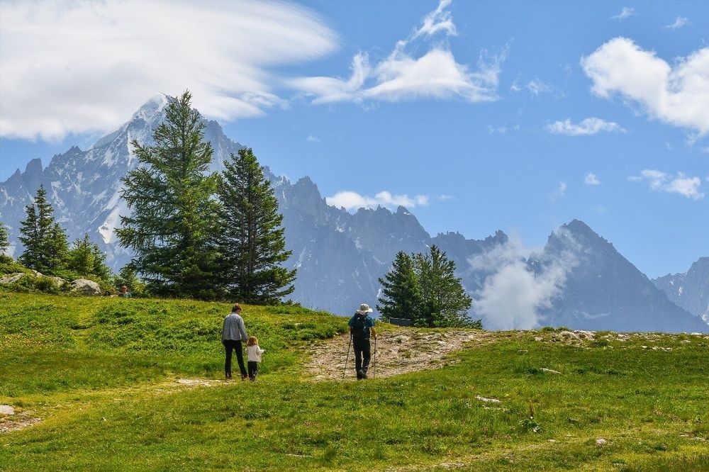
© Shutterstock
 Votre guide Ryo
Hiking in Haute-Savoie: the 15 Best Walks and Summits (2026)
Hiking in Haute-Savoie has a unique quality: it is one of the few French departments where you can choose your own level of exposure. Starting from the same village, a beginner hiker can reach an alpine lake in two leisurely hours, while an experienced mountaineer heads for a pass at 2,800 m. It is no coincidence that the area boasts more than 3,500 km of marked trails, more than most European massifs taken individually. To plan your stay on the city side, the Ryo audio guide to Aix-les-Bains and the Riviera des Alpes is an excellent complement for discovering the region between mountain outings.
In this guide, you will find 15 hand-picked itineraries: Lac Blanc facing the Aiguilles de Chamonix, the Cirque de Sixt-Fer-à-Cheval and its vertiginous waterfalls, la Tournette towering 800 m above Lac d'Annecy, the Dent d'Oche with its 360° panorama over Lake Geneva, and lesser-known gems such as Lac Darbon in the Chablais and the Trou de la Mouche in the Bornes massif. Each entry specifies the distance, elevation gain, true difficulty level, and the best season to go.
Why Haute-Savoie Is an Exceptional Hiking Destination
What makes hiking in Haute-Savoie so rich is, first and foremost, its geography: three distinct massifs share the department — the Préalpes du Chablais to the northwest, the Aravis in the centre, and the Mont-Blanc massif to the east. This geological diversity explains why landscapes change radically from one slope to the next: beech and fir forests on the Chablais side, open alpine pastures on the Aravis side, glaciers and granite walls on the Chamonix side.
The trail network is managed by the Departmental Council and local tourist offices, which ensure regular waymarking. The GR (Grande Randonnée) routes cross the department in several arcs: the GR 5, which links Lake Geneva to the Mediterranean, passes through Chamonix and the Col du Mont-Blanc. Even more iconic, the Tour du Mont-Blanc (TMB) is now one of the most frequented trails in Europe: tens of thousands of passages are recorded every summer, with up to more than 1,000 walkers per day in peak season on the 170 km of the full circuit.
The main season runs from June to mid-October for high-altitude hikes. Below 1,500 m, the window extends from April to November. Winter opens another activity: snowshoeing and ski touring (skimo) are highly developed in the Aravis and Bargy massifs. The department has several areas specialising in marked skintracks, particularly around La Clusaz and Grand-Bornand.
One final figure that gives a sense of scale: Haute-Savoie is home to 13 natural high-altitude lakes accessible on foot from a car park or a cable car. These lakes are often the main destination for weekend hikers. Their relative accessibility and photogenic beauty make them ideal spots for family or group outings.
Lac Blanc and the Lacs de Chéserys, Facing Mont-Blanc
This is the iconic hike in the Chamonix area, and probably the most photographed in all of Haute-Savoie. The Lacs de Chéserys and Lac Blanc offer a reflection of the Mont-Blanc massif at an altitude of 2,352 m — an image seen in every travel guide, yet still breathtaking when you arrive there for the first time.
Two approaches are possible. The first departs from the Chalet de la Flégère (accessible by gondola from Les Praz-de-Chamonix), reducing the walk to 7 km round trip with 600 m of elevation gain; allow 3h30 including photo stops. The second starts from l'Index (accessible by cable car) and reaches the lake via a nearly flat high-mountain trail of 2 km — an ideal option for families or those uncomfortable with significant elevation gain.
If you prefer to do everything on foot from the valley, the ascent from Les Tines covers 13 km and 1,400 m of elevation gain — a full and demanding day. In any case, lightweight crampons remain useful until July for crossing certain snowfields.
The Lacs de Chéserys are discovered along the way to Lac Blanc, strung out like beads at a slightly lower altitude. Each lake offers a different perspective on the Aiguilles Rouges (lake side) and on the Aiguille du Midi (Mont-Blanc side). Sunset over these lakes is a rare spectacle, but it requires an overnight stay at the Lac Blanc refuge (€28 in a dormitory, booking essential in July–August).
Please note: the area is part of the Réserve naturelle des Aiguilles Rouges; dogs are not permitted on the trail and bivouacking is prohibited.
Level: moderate to difficult depending on approach | Elevation gain: 600 to 1,400 m | Best season: July–September
Cirque de Sixt-Fer-à-Cheval, an Amphitheatre of Waterfalls
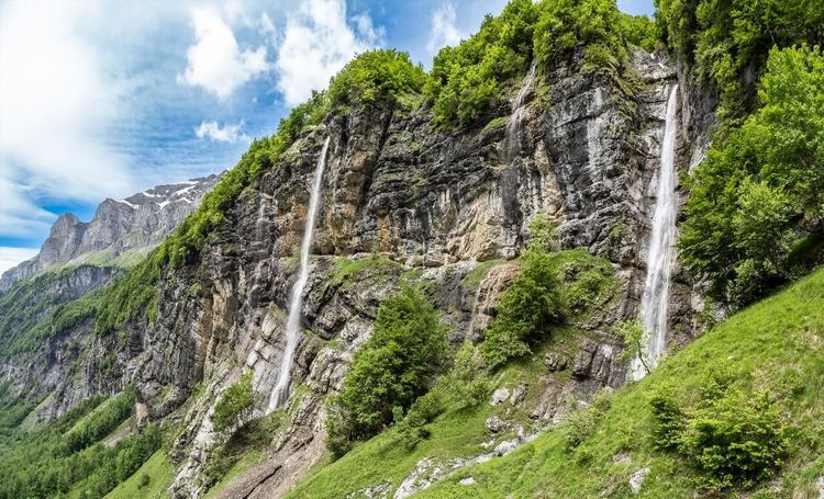
The Cirque de Sixt-Fer-à-Cheval (Route du Cirque, 74740 Sixt-Fer-à-Cheval, rated 4.8/5 on Google from 5,471 reviews) has been classified as a National Nature Reserve since 1977. This 9,000-hectare site in the Giffre valley forms an almost perfectly circular rocky amphitheatre, dotted with around thirty waterfalls that tumble down limestone cliffs hundreds of metres high in spring. In spring and early summer, snowmelt turns every gully into a white torrent — this is the best time to enjoy the spectacle.
The classic cirque-floor itinerary covers 12 km round trip with a very modest elevation gain of 200 m — one of the rare major Haute-Savoie hikes within reach of a beginner or a family with children aged 8 and over. Allow 3 hours at a good pace, or a full day if you stop to picnic in front of the Bout du Monde waterfalls.
For more experienced hikers, Lac de la Vogealle extends the outing by an additional 3 km and 700 m of elevation gain from the cirque floor. It is reached via a steep path through conifer forest; the reward is a turquoise lake ringed by vertical walls, practically deserted outside of July weekends.
The village of Sixt-Fer-à-Cheval is worth a detour: its 18th-century Savoyard houses and Premonstratensian abbey make it one of the most beautiful villages in the Giffre valley. Paid parking in high season (€6/day), free shuttles from Samoëns at weekends from July to August.
Level: easy (cirque floor) to moderate (Lac de la Vogealle) | Elevation gain: 200 to 900 m | Best season: May–October
La Tournette, the Balcony above Lac d'Annecy
The iconic summit of the Aravis on the Annecy side, la Tournette peaks at 2,351 m and provides one of the most spectacular panoramas in the department: Lac d'Annecy unfolds 800 m below, framed by the Bauges to the west and the Bornes to the north. On a clear day, Mont-Blanc can be seen to the east and the Écrins to the south.
The classic approach starts from Col de la Forclaz (1,157 m), on the Talloires side. The trail climbs steadily through alpine pastures before tackling a rocky ridge fitted with fixed cables near the summit. Total distance: 12 km round trip | Elevation gain: 1,200 m | Duration: 5 to 6 hours depending on pace. The cabled section is not rock climbing, but it does require good fitness and a head for heights.
A less crowded alternative starts from Montmin (Plateau des Glières side) and reaches the summit via the north face. This slope is wilder, with less-frequented pastures and views over the Bornes rather than the lake — a great option for varying the ascent and descent routes.
Avoid July–August weekends on this summit: it attracts up to 500 visitors per day in peak season. The best windows are weekday mornings in September, when the light is golden and the crowds are absent.
Level: difficult (cabled section) | Elevation gain: 1,200 m | Best season: July–October
Lac Darbon, a Wild Gem of the Chablais
Less well known than Lac Blanc or la Tournette, Lac Darbon (Col de Terramont, 74500 Saint-Paul-en-Chablais, rated 4.9/5 on Google from 82 reviews) is a discreet gem in the Chablais massif. This small high-altitude lake at 1,780 m long went unnoticed by mainstream guides before a few social-media photos brought it to wider attention. As a result, it remains far less crowded than its counterparts in the Chamonix valley.
The main itinerary departs from Col de Terramont (1,450 m) and climbs through forest then open alpine pastures. 6 km round trip | 330 m elevation gain | approximately 2h30. The difficulty is light, making it an excellent option for a first high-altitude outing with children or for a summer afternoon.
The lake itself is small — less than a hectare — but its open setting with views over Lake Geneva and the Swiss Alps makes it unforgettable. In late afternoon in summer, the light there is particularly soft. Bring a picnic, as there is no infrastructure on site.
Level: easy | Elevation gain: 330 m | Best season: June–October
Dent d'Oche, Panorama over Lake Geneva
The Dent d'Oche (La Chapelle-d'Abondance, 74360 La Chapelle-d'Abondance, rated 4.9/5 on Google from 134 reviews) is the dominant summit of the Chablais at 2,222 m. From its top, Lake Geneva is revealed in its full length — a 72 km expanse seen from altitude, with the Vaudois Alps as a backdrop on the Swiss side. It is one of the finest lake perspectives in the French Alps.
The start is from La Chapelle-d'Abondance (950 m) or from the Chalets d'Oche at an intermediate access point (1,450 m). The full itinerary from the chapel covers 13 km with 1,270 m of elevation gain — a fine full day of hiking. The ascent is gradual as far as the Chalets d'Oche, then steeper on the final ridge with some exposed rocky sections.
The Refuge des Chalets d'Oche (1,452 m) offers the possibility of splitting the ascent over two days: a relaxed first day from the valley to the refuge, and a second day for the summit and descent. An overnight stay costs around €45 half board; book well in advance for July weekends.
In a shorter version, it is possible to stop at the Chalets d'Oche after crossing alpine pastures covered in gentians and rhododendrons in spring. The panorama from the chalets is already very generous without requiring the final ascent.
Level: moderate to difficult | Elevation gain: 700 to 1,270 m depending on starting point | Best season: June–October
Plateau du Semnoz, a Panoramic Walk above Annecy
While la Tournette demands its kilometre of elevation gain, the Plateau du Semnoz (Crêt de Chatillon, 74000 Annecy, rated 4.8/5 on Google from 49 reviews) operates in an entirely different register. This panoramic ridge at 1,699 m overlooks Annecy to the west and offers open views over the Alps without requiring disproportionate physical effort. The departmental road climbs to 1,656 m, reducing the elevation gain to just a few tens of metres for the shortest itineraries.
The main ridge trail covers 8 km round trip from Crêt de Chatillon to the Chalet de la Sambuy. Allow 3 hours for a relaxed outing with breaks and photos. In winter, the plateau is accessible on snowshoes from Annecy with as little as 40 cm of snow.
Once your hike is done, Annecy is well worth exploring in town. To extend your cultural discovery on the Savoyard spa side, the Ryo audio tour of Aix-les-Bains takes you in 1h16 along the Riviera des Alpes with 14 audio stops on the city's Belle Époque heritage — a perfect way to round off a day in the mountains.
Level: easy to moderate | Elevation gain: 100 to 400 m | Best season: April–November, December–March (snowshoes)
Mont Charvin, a Wild Summit in the Aravis
The Mont Charvin (Col des Aravis, 74230 Thônes, rated 4.9/5 on Google from 82 reviews) (2,409 m) is the anti-celebrity of the Aravis: absent from postcards, overshadowed by its more media-friendly neighbours, it nonetheless delivers an exceptional panorama over the Aravis and Mont-Blanc, along with a high-mountain atmosphere relatively free from crowds.
The most direct access starts from Col des Aravis (1,486 m). The path first climbs a long, gently sloping pasture, then veers onto a rocky ridge before the summit. 9 km round trip | 950 m elevation gain | 4 to 5 hours. The main difficulty lies in the last 300 metres over rocky terrain, requiring boots with rigid soles.
Mont Charvin is a favourite playground for trail runners looking to avoid the crowds of Chamonix. In September–October, the larches turn yellow and orange — this is the finest season for this massif, often blessed with sunny days and crystal-clear air.
From the summit, the view plunges down into the Val d'Arly on one side and over the Aravis range on the other, with the Mont-Blanc massif in the background. In very good visibility, the Swiss summits of the Grand Combin can be spotted.
Level: moderate to difficult | Elevation gain: 950 m | Best season: June–October
Lac de Lessy and the View of the Aiguille Verte
This hike combines two objectives in a single outing: Lac de Lessy (Plateau des Glières, 74130 Thorens-Glières, rated 4.8/5 on Google from 418 reviews) (1,922 m), a small high-altitude lake with emerald reflections, and the view of the Aiguille Verte (4,122 m) rising directly opposite from the flat section. The combination is striking — a tranquil lake in the foreground, a wall of ice and granite behind.
The start is from the Plateau des Glières (1,440 m), itself accessible from Thorens-Glières. The itinerary climbs steadily through forest and alpine pastures over 10 km round trip with 490 m elevation gain — a half-day outing for a hiker in good shape. In July, the pastures are carpeted with buttercups and wild orchids.
The Plateau des Glières is worth a stop in its own right: this high plateau is a site of memory for the French Resistance (Maquis des Glières, 1944). The National Resistance Memorial can be visited free of charge and tells the story of the 465 maquisards who defended this plateau against the Vichy forces and the Wehrmacht in spring 1944. Back down in Annecy, Ryo's ‘Venice of the Alps' audio walking tour (21 stops, just over an hour) makes for a gentle wind-down along the lake.
Level: moderate | Elevation gain: 490 m | Best season: June–October
Le Pas du Roc, a Cliffside Hike
The Pas du Roc (Gorges du Fier, 74290 Lovagny, rated 4.8/5 on Google from 122 reviews) is one of the most original hikes in Haute-Savoie. The itinerary follows a limestone cliff along a path cut directly into the rock, with sections equipped with cables and ladders. This is not a via ferrata — the difficulties remain accessible to hikers used to mixed terrain — but the exposure is real and impressive.
The itinerary starts from Lovagny and follows the Gorges du Fier for 8 km with an elevation gain of 600 m. Allow 3h30 to 4h round trip. The technical section lasts around 45 minutes and covers about fifty metres of vertical elevation gain on fixed equipment. Boots with rigid soles are essential; trainers are strongly inadvisable.
This hike lends itself very well to a group outing, thanks to its playful character and the measured adrenaline it provides. Children aged 10–12 and over, accompanied by adults, can tackle it without any problem.
Level: moderate (technical sections) | Elevation gain: 600 m | Best season: May–October
Trou de la Mouche, the Bornes Massif Goes Vertical
The Trou de la Mouche (Massif des Bornes, 74450 Saint-Jean-de-Sixt, rated 4.8/5 on Google from 97 reviews) (2,454 m) is the highest point of the Bornes massif. Its enigmatic name conceals a summit of real character, accessible from Saint-Jean-de-Sixt or La Clusaz. From the top, the panorama takes in the Aravis, the Bornes massif, and the Préalpes all the way to Lake Geneva.
10 km round trip | 1,000 m elevation gain | 4h30 to 5h. The itinerary from Saint-Jean-de-Sixt first climbs through forest before reaching the open alpine pastures of Plan Bois, then a rocky ridge up to the summit.
The Bornes massif remains less frequented than Chamonix or the Aravis while offering authentic high-mountain terrain less than an hour from Annecy. An option worth keeping in reserve for weekends when Lac Blanc is fully booked.
Level: moderate to difficult | Elevation gain: 1,000 m | Best season: July–October
Lac Vert at Passy, View of the Mont-Blanc Massif
The Lac Vert (Plateau d'Assy, 74480 Passy, rated 4.7/5 on Google from 1,159 reviews) at Passy is one of the easiest hikes in the department with a view of the Mont-Blanc massif. Its emerald-green tint is caused by microscopic algae that colonise its cold waters — a natural phenomenon that gives it an almost surreal appearance in fine weather.
Access from the Plateau d'Assy (1,000 m): 3 km round trip | 150 m elevation gain | 1h30. In summer, swimming is permitted on a small designated beach at the lakeside.
Level: very easy | Elevation gain: 150 m | Best season: June–September
Winter Hiking: Ski Touring and Snowshoeing
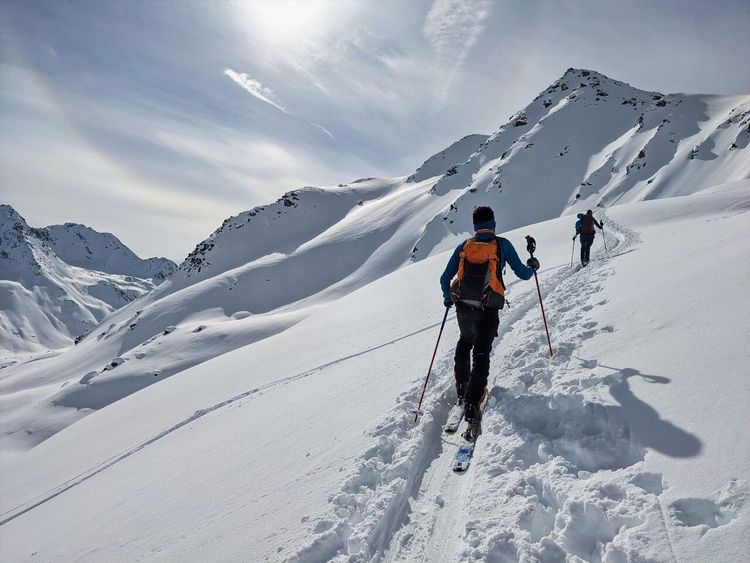
Hiking in Haute-Savoie does not stop when the fine weather ends: the department does not go to sleep in November. It is one of the most active departments in France for winter off-piste activity, with two disciplines growing every year: ski touring (skimo) and snowshoeing.
Ski touring has become considerably more accessible since 2020. The Aravis and Bargy massifs offer marked skintracks from the resorts of La Clusaz and Grand-Bornand — uphill routes accessible to beginners in skimo with a guide. The Croix de Fer (1,504 m) from La Clusaz and the Col du Rasoir from Grand-Bornand are two classics for a first ski touring outing.
For snowshoeing, the options are even more plentiful. The Plateau du Semnoz is accessible on snowshoes from Annecy with as little as 40 cm of snow. The Col des Aravis and the Combloux-Megève area offer marked itineraries of 5 to 12 km from altitudes of 1,000–1,200 m. In the Chablais, the Monts de Feternes (1,250 m) provide a perfect introduction for families.
Essential winter precautions: always check the avalanche bulletin from Météo France before setting out (risk rated 1 to 5). Carry an avalanche transceiver (DVA), a probe, and a shovel for any off-piste outing, however short. If in doubt, contact a high-mountain guide; the SNGM (Syndicat National des Guides de Montagne) lists accredited guides by massif on its official website.
Ski schools generally offer introductory snowshoe days from November to March for €40–60 per person — a good way to get started before investing in your own equipment.
Preparing Your Hike in Haute-Savoie: Gear and Tips
Preparation makes the difference between a great day and a misadventure. A few essential points for hiking in Haute-Savoie without any nasty surprises.
Footwear: high-ankle hiking boots with a rigid sole (Vibram type) are essential above 1,500 m. Trail running shoes are fine for well-marked paths below 1,200 m but become dangerous on rocky or wet terrain. To choose the right footwear for your activity, see our dedicated hiking footwear guide.
Telescopic poles: recommended for all hikes with more than 800 m of elevation gain; they reduce the load on the knees on the descent by 20 to 30% — a notable saving of effort on long days.
Backpack contents: at a minimum, 2 litres of water per person, a sugary snack, an emergency blanket, a charged phone, and a waterproof rain poncho. At altitude, the weather can change within 30 minutes — never set out without rain gear.
Weather and safety
The Météo France mountain forecast (massif forecasts) is the go-to reference to check the evening before and on the morning itself. It distinguishes valley-floor weather from summit conditions — a clear sky below can correspond to violent storms at 2,000 m in early afternoon.
Golden rule: start early. Convective storms form between 2 p.m. and 5 p.m. in summer over the Alpine massifs. A 7–8 a.m. departure allows you to reach the summit before noon and descend before the storms arrive. If you reach the summit after 12:30 p.m. and cumulus clouds are building on the horizon, begin your descent without hesitation.
Maps and navigation
IGN 1:25,000 maps (Top 25 series) cover the department in about a dozen sheets. The Komoot, Visorando, and AllTrails apps offer downloadable offline GPS tracks, useful in areas without mobile coverage. Trails are waymarked with the official FFRandonnée markings: red and white for GR routes, yellow for PR routes (short local trails).
Refuges and resupply
Haute-Savoie has several dozen staffed mountain refuges spread across the massifs. Prices range from €25 (dormitory) to €70 (half board) depending on the refuge. Booking is mandatory for popular refuges such as Lac Blanc or Lacs Jovet in July–August. Outside the peak season (June and September), most do not require advance booking.
Combining Hiking and Cultural Discovery
Haute-Savoie is not merely a collection of marked trails. Between hikes, the area holds an architectural and historical heritage that is often underestimated by walkers in a hurry to reach their next pass.
Annecy is the department's unmissable urban highlight: its old quarter around the Canal du Thiou, its medieval castle, and its Tuesday–Friday market make it a city where non-hikers in the group are equally delighted. A cycling tour of the lake (21 km) is an alternative to hiking on rest days or in poor weather.
Chamonix is not limited to the mountains: the Musée des Cristaux and the Espace Tairraz attract as many visitors as the trails. In the evening, the Rue des Moulins is home to the best Savoyard restaurants.
For historic Savoy, two cities in our Ryo network offer complementary audio-guided itineraries. The Ryo audio-guided tour of Chambéry covers in 1h30 the 23 audio stops of the historic capital of Savoy — ducal castles, the Fontaine des Éléphants, the old comtal town. A rich programme over 3.4 km that illuminates a thousand years of Alpine history. If your itinerary takes you towards Lac du Bourget, Aix-les-Bains deserves a half-day for its thermal baths and Belle Époque villas.
FAQ
What is the most beautiful hike in Haute-Savoie?
The answer depends on your level and preferences. For absolute views, Lac Blanc facing Mont-Blanc (accessible from Chamonix) is most often cited first. For a wilder, less crowded atmosphere, Mont Charvin in the Aravis or Lac Darbon in the Chablais are excellent alternatives. La Tournette above Annecy remains the most spectacular summit for hikers in the Annecy area.
Which hike in Haute-Savoie is suitable for families?
Several options are suitable for children. The Cirque de Sixt-Fer-à-Cheval (cirque floor, 200 m elevation gain) is accessible from age 6–7. Lac Vert at Passy (150 m elevation gain, 3 km round trip) is accessible from age 5. The Plateau du Semnoz, with road access up to 1,656 m, allows for 1 to 2-hour walks without excessive effort for young children.
When is the best time to hike in Haute-Savoie?
For high-altitude hiking in Haute-Savoie, July and August offer the best accessibility but also the highest visitor numbers. September is often the best period: clear trails, autumn light, fewer people. Below 1,500 m, hikes are feasible from May to November.
Are there hikes in Haute-Savoie that can be done in winter?
Yes, ski touring and snowshoeing are very well developed in the department. The La Clusaz, Grand-Bornand, and Megève-Combloux areas offer marked skintracks accessible to beginners. The Plateau du Semnoz and the Monts de Feternes are the most accessible snowshoeing zones without mandatory avalanche safety equipment (low risk below 1,600 m).
How do you prepare for a hike in Haute-Savoie?
Five key steps: check the Météo France mountain forecast the evening before and on the morning itself, download the GPS track on Komoot or AllTrails in offline mode, wear high-ankle boots with a rigid sole, bring 2 litres of water and an emergency blanket, and plan to set off before 8 a.m. to descend before the afternoon storms.
Do you need a guide to hike in Haute-Savoie?
For well-marked PR and GR trails, a guide is not necessary. One is strongly recommended for hikes involving off-trail sections, glaciers, or ski touring in avalanche-risk zones. Guide offices in Chamonix, Annecy, and the Aravis offer full-day accompaniment for €70 to €120 per person.
Conclusion
From the turquoise lakes of the Chablais to the granite walls of Chamonix, by way of the reblochon-scented alpine pastures of the Aravis, hiking in Haute-Savoie offers a diversity of itineraries that would take years to exhaust. Whatever your fitness level or goal, this department has a trail for you. Between mountain outings, take the opportunity to explore the region's towns: the Ryo audio guide to Chambéry takes you through the historic capital of Savoy in 1h30, with 23 stops that illuminate a thousand years of Alpine history — a different way of walking, this time in the footsteps of the Dukes of Savoy.
À lire également