Créé par Emilie, le 20 juin 2026
Votre guide Ryo
What You Really Need to Do in Southern Corsica: 14 Must-See Sites in 2026
© Shutterstock
Southern Corsica achieves something that few French regions can still claim: concentrating, within less than 4,000 km², limestone cliffs plunging into the Mediterranean, granite needle forests at over 1,600 meters altitude, and beaches whose transparency rivals those of the Caribbean. Listing what there is to do in Southern Corsica first means accepting that it far exceeds what ten days allow you to see. To discover Ajaccio at your own pace and without wasting time looking for your bearings in the city, the Ryo audio guide tour of Ajaccio covers 18 points of interest in 2h30, from Napoleon's birthplace to the Genoese ramparts.
This guide lists 14 sites and areas, chosen to cover all aspects of Southern Corsica: Bonifacio perched on 70 meters of white cliffs with its 187 steps carved into the rock, a preserved archipelago where the sea reveals the seabed at 15 meters deep, rock formations classified as UNESCO World Heritage that half the tourists only see while rushing past, and Alta Rocca villages where some dry stone walls date from the Bronze Age. A car is essential to connect everything, but the result is worth every kilometer.
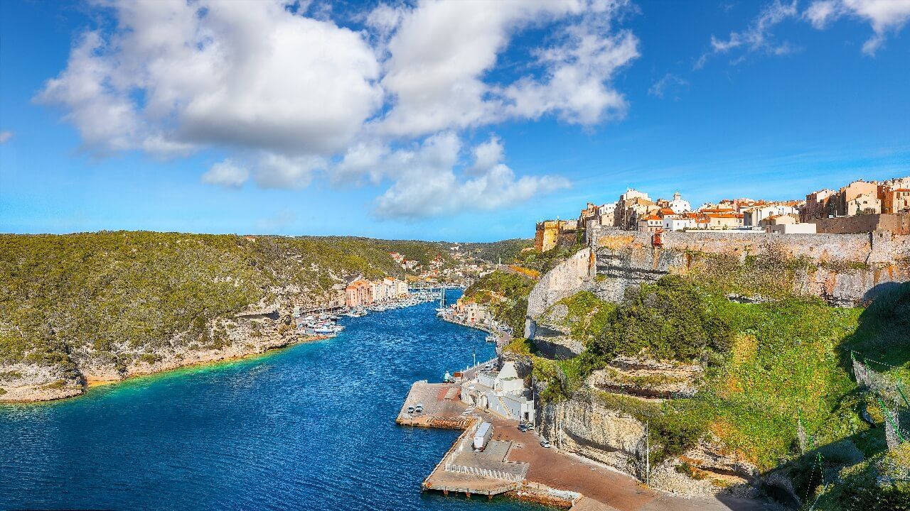
Bonifacio: the City Suspended on Its Cliffs
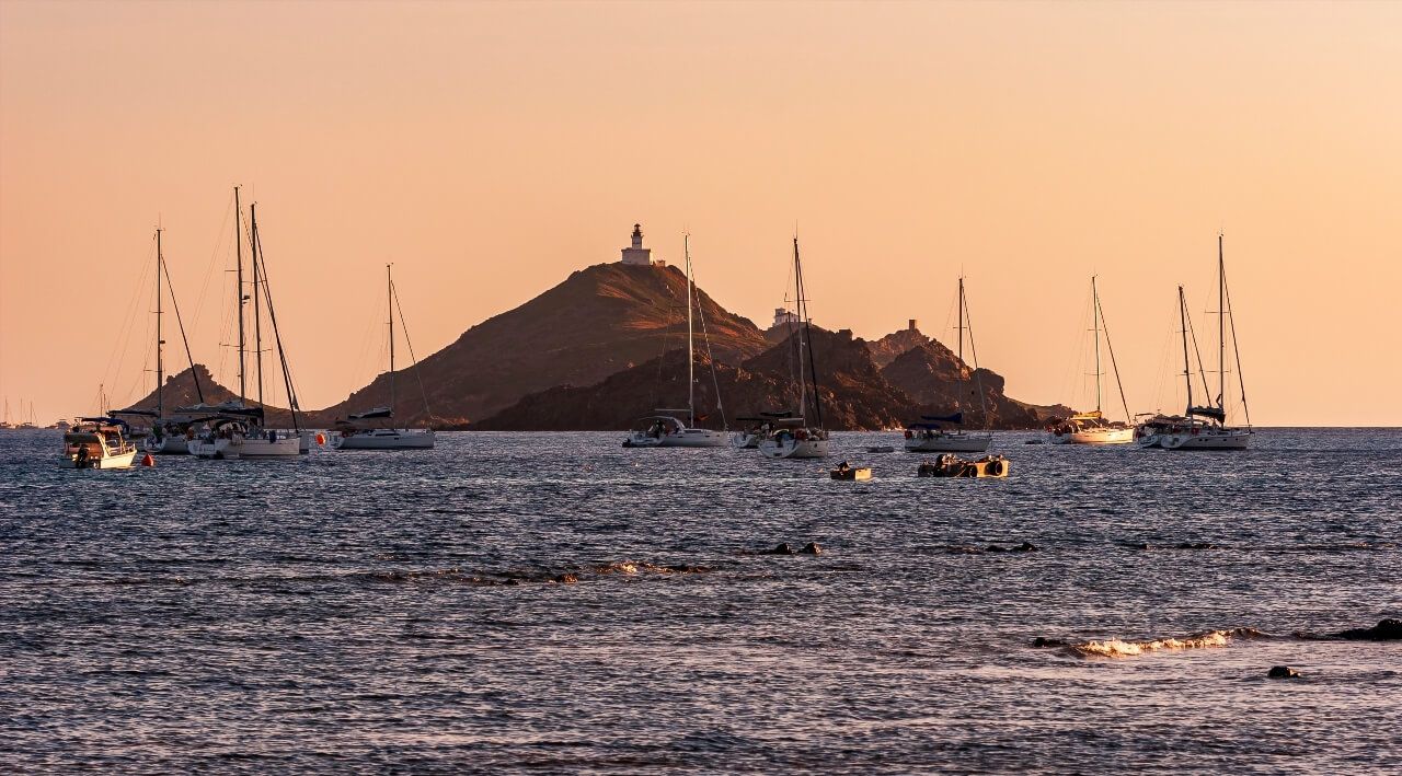
Bonifacio holds a geographical position without equivalent in mainland France. The upper town extends on a white limestone promontory, at 70 meters above sea level, at the end of a natural corridor facing the strait separating Corsica from Sardinia. From the ferry, or from a pleasure boat, the silhouette gives the impression of a city placed on emptiness, houses suspended at the edge of the cliffs as if they had forgotten to fall.
The upper town concentrates most of what there is to see. The Sainte-Marie-Majeure church, founded in the 12th century, preserves an exterior loggia and a Romanesque cistern that served to collect rainwater to supply the citadel in case of siege. The interior, sober and with Romanesque proportions, contrasts sharply with the baroque facades found elsewhere in Corsica. From the Genoese bastions, built from the 14th century and largely intact, the panorama simultaneously embraces the strait, the marina below and the Sardinian coasts in clear weather. The Standard bastion is the most open viewpoint, freely accessible from rue des Deux-Empereurs.
The citadel alleys deserve to be explored without a fixed itinerary. Most houses date from the 15th and 16th centuries, their grey limestone facades lean on each other through relieving arches that sometimes span the entire width of the alley. Some of these passages are so narrow that you cross them sideways. It's in these streets that Bonifacio least resembles a postcard, and most resembles a city that has truly lived.
Save time to go down to the marina. Departures for the Lavezzi islands, marine caves and excursions to the Sardinian coast depart from here. The Dragonato cave, accessible only by sea, filters light in such a way as to form the silhouette of a map of Corsica on the walls: the phenomenon is visible in late morning between May and September.
Practical: the marina parking is paid in season, but the simplest option is to park in the upper town and walk down via rue Saint-Erasme. Most buses drop their passengers at the Porte de Gênes level. Before 9am or after 5pm, the human density in the alleys drops significantly. Allow two hours for the citadel alone, plus 45 minutes if you include the descent to the marina.
The King of Aragon Staircase
Carved directly into the limestone cliff, the 187 steps of the King of Aragon staircase (Bonifacio, 20169 Bonifacio, rated 4.5/5 on Google for 11,957 reviews) descend in an almost vertical line from the Bonifacio citadel to the rocks at the water's edge. Legend attributes their carving to Aragonese soldiers during the 1420 siege, a single night of work according to tradition. Archaeologists are more cautious: the staircase probably served for water supply from a source at the bottom of the cliff, and its construction was spread over a longer period.
The exact history doesn't matter. What counts is the descent itself: the white limestone wall on one side, the Mediterranean below on the other, the steps polished by centuries of feet. Plan for non-slip shoes, the steps are smooth and can be wet even in summer. Access is paid (2.50 euros approximately). The climb back up takes less than ten minutes but strains the knees, to avoid for those with joint difficulties.
The view from the bottom of the staircase, looking up at the citadel outlined against the sky, is different from anything seen from the upper town viewpoints. It's an angle that few photos show.
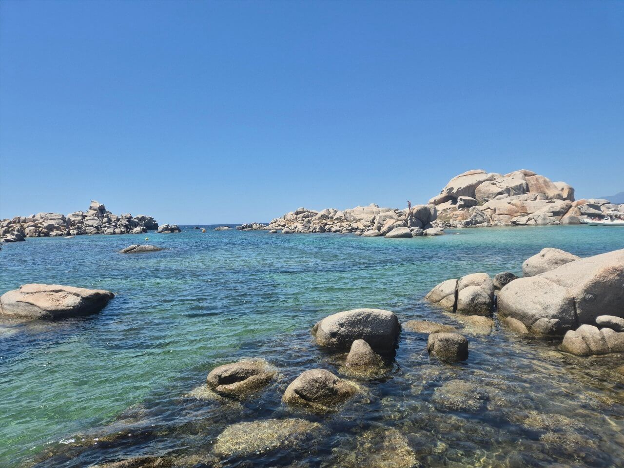
The Lavezzi Islands: the Preserved Archipelago
At 12 kilometers off Bonifacio, in the strait separating Corsica from Sardinia, the Lavezzi islands constitute a nature reserve protected since 1982. The archipelago groups together about ten uninhabited granite islets, low on the water, with low vegetation of immortelles and lentisks. What strikes first is not the vegetation, it's the sea: white sandy bottoms visible at 10 to 15 meters depth, water oscillating between turquoise and an almost green blue depending on the angle of the sun.
Access is only from Bonifacio marina, crossing of 30 to 45 minutes depending on sea conditions. Several companies offer daily excursions with multiple swimming stops, count 25 to 35 euros per person. The number of daily visitors has been capped by prefectural decree since 2019: 500 people maximum per day on the main island of Lavezzu. In July and August, booking the day before minimum has become essential, some days, boats are fully booked from the morning of the same day.
The site's preservation is remarkable. No constructions, no sales points, strictly delimited mooring areas. The beaches are white quartz sand, the rounded rocks form natural basins where water remains calm even when wind picks up on the open sea. It's exactly what many travelers hope to find in the Mediterranean and rarely find.
A page of history little mentioned in standard guides: the Sémillante obelisk, visible from the boat approaching the archipelago, commemorates the wreck of the French military frigate Sémillante in February 1855. The ship was carrying 773 soldiers and sailors to the Crimean War when the storm broke it on the rocks. There were no survivors. The presence of this white monument in the middle of the Mediterranean blue gives unexpected historical depth to what is often presented as a pure beach excursion. Prosper Mérimée, who traveled Corsica on behalf of historical monuments, had reported these rocks as particularly dangerous a few years before the catastrophe.
Tip: morning excursions (departure 8:30-9am) allow you to arrive before the day's heat and before the 500 places are exhausted. Bring snorkel gear, the bottoms are exceptionally clear even from the surface.
Porto-Vecchio: Between Genoese Citadel and Deep Gulf
Porto-Vecchio simultaneously plays two registers that few Corsican towns manage to hold together: very popular seaside resort in summer, and town endowed with a 16th-century Genoese citadel that reads like an open-air historical document. The upper town, encircled by granite ramparts, dominates the gulf from a limestone hill at 90 meters altitude. The view from the terraces of Place de la République covers the entire gulf up to the Cerbicale islands in clear weather.
The citadel alleys concentrate the most interesting Corsican gastronomy addresses: charcuterie (lonzu, coppa, figatelli), brocciu cheese, dried charcuteries and Figari wines. The local rule, valid throughout Corsica, applies here with even more force: avoid restaurants directly on the main square with laminated menus and prices proportional to the view. Good restaurants are in perpendicular alleys, identifiable by their chalk-written blackboards.
The Porto-Vecchio gulf is one of the deepest in Corsica, which explains why the town became a natural port from Phoenician then Roman antiquity. Today, the marina hosts departures to the Cerbicale islands, a nature reserve where ospreys nest. The gulf's underwater depths, particularly around Cala Rossa, are among the best-rated diving sites in the south of the island: posidonia seagrass meadows in excellent condition, groupers, moray eels.
At 15 minutes by car inland, the Ospédale forest offers an immediate counterpoint to the summer bustle of the coast: centennial laricio pines, artificial lake and picnic areas in relative silence even in mid-July.
Palombaggia, Santa Giulia, Rondinara: Three Beaches, Three Temperaments
Southern Corsica has several dozen remarkable beaches. Three of them concentrate international notoriety based on very different qualities, knowing them distinctly allows avoiding finding yourself in the wrong cove with the wrong expectations.
Palombaggia, at 18 kilometers south of Porto-Vecchio, is organized in three successive coves separated by pink rocks. The first cove, closest to the parking, is systematically saturated from June to September. The third cove, at the end of the path that runs along the umbrella pines, welcomes half as many people for the same quality of water and sand. The main parking is paid in high season; arriving before 9:30am guarantees a spot and access to still shaded areas.
Santa Giulia, at 22 kilometers from Porto-Vecchio, occupies a semi-closed lagoon that produces naturally warmer and calmer water than Palombaggia. It's the beach best suited to families with young children: shallow depth over a wide coastal strip, no current, flat sandy bottom. The back of the beach is invaded by campgrounds and vacation residences, wilderness has given way to infrastructure, but water quality is intact.
The Rondinara beach (Route de la Rondinara, 20169 Bonifacio, rated 4.4/5 on Google for 6,180 reviews), between Porto-Vecchio and Bonifacio, is the least internationally known of the three and the most spectacular in terms of shape: a perfectly circular bay, like a natural basin carved in granite, with a central islet and white sand that turns to pinkish ochre depending on the time. Access involves 15 minutes on foot from the parking (rocky terrain, shoes advised). Attendance remains measured compared to the other two beaches, partly because of this pedestrian access that discourages the least motivated visitors.
Practical information that few guides still mention: Tamaricciu beach, accessible on foot from Palombaggia parking (20 minutes trail), offers the same sand and water qualities as Palombaggia with significantly lower attendance. It's the alternative to remember for those who want white sand without the high season density.
Ajaccio: Bonaparte's City and Much More
Ajaccio is the only Corsican city to have given birth to a figure who reorganized the map of Europe. Napoleon Bonaparte was born here on August 15, 1769, in a house on rue Saint-Charles that has been visited since 1924 under the management of the National Monuments Center. The Bonaparte House preserves period furniture, a reconstructed birth alcove and an Empire-decorated room that documents the family's trajectory from modest Corsican nobility to the Consulate. Entry costs 7 euros.
But Ajaccio doesn't reduce to the Napoleonic narrative, even though it's everywhere: on squares, in street names, on local banknotes (so to speak, but Napoleon's image is indeed omnipresent in shops). The Fesch Museum, housed in a 19th-century palace bequeathed to the city by Cardinal Joseph Fesch, Napoleon's maternal uncle, holds the most important collection of Italian paintings in France outside the Louvre. The cardinal bequeathed to his native city about a thousand paintings from his personal collection, which counted some 16,000 works at his death: you'll find Titian, Botticelli, Bellini and Veronese. Access is paid (9 euros in 2026), the building alone with its arcaded facade and Italian garden is worth the entrance.
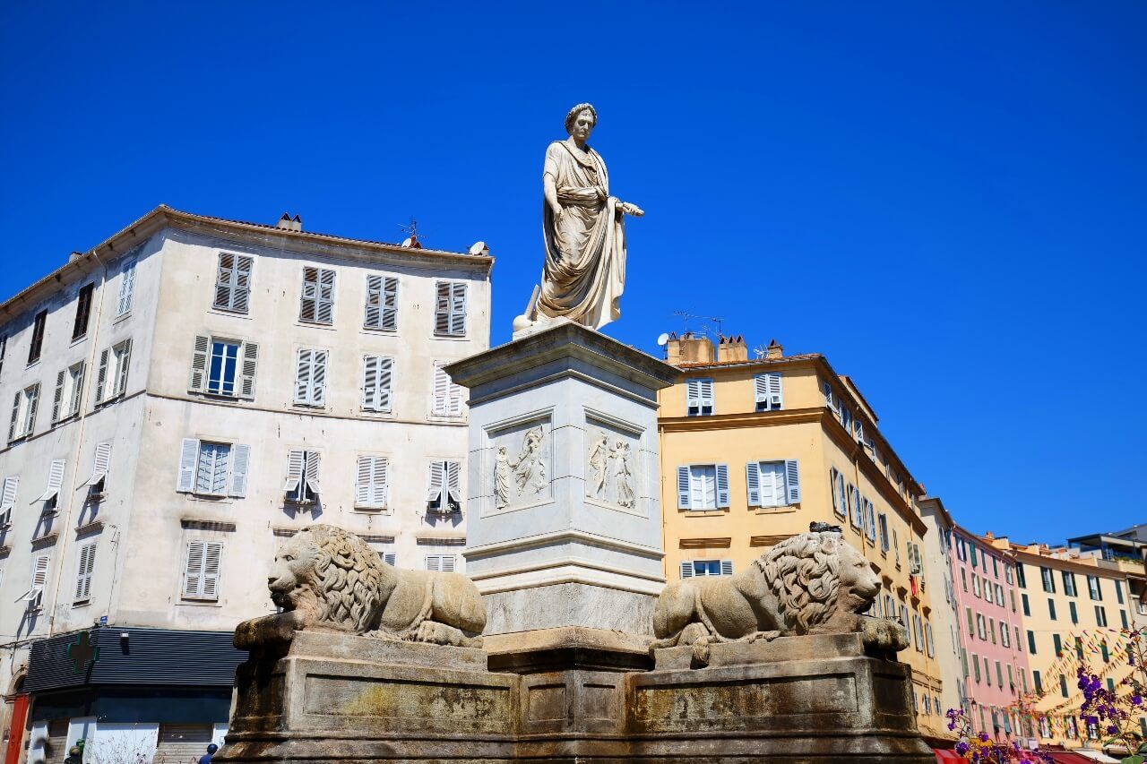
The city center is organized around Place Foch, formerly Place du Diamant, dominated by the statue of Napoleon as a Roman consul. Café terraces extend to the covered market where local producers sell Corsican cheeses, maquis honey and dried charcuterie from 7:30am. Cours Napoléon, Corsica's longest boulevard, extends the square northward with its arcades, bookshops and neighborhood stores.
To connect all these points without wasting time consulting maps at every street corner, the Ryo audio guide of Ajaccio offers 18 commented audios on a 6-kilometer route, from the Bonaparte House to the Genoese citadel ramparts. Allow 2h30 of walking at your own pace, without time or group constraints.
The citadel itself is partially military, its interior parts are closed to the public, but the facade and ramparts can be discovered from the waterfront promenade accessible freely. For hiking enthusiasts, the ridge trail accessible 15 minutes by car from the center reaches viewpoints over the Gulf of Ajaccio from the heights. Barbicaja beach, 3 kilometers from the center along the coast, is the most accessible beach on foot for those staying in town.
Planning: Ajaccio is worth a full day minimum, two if you include the Sanguinaires route. Avoid the Bonaparte House queues by arriving at opening (10:30am). The covered market closes at 1pm.
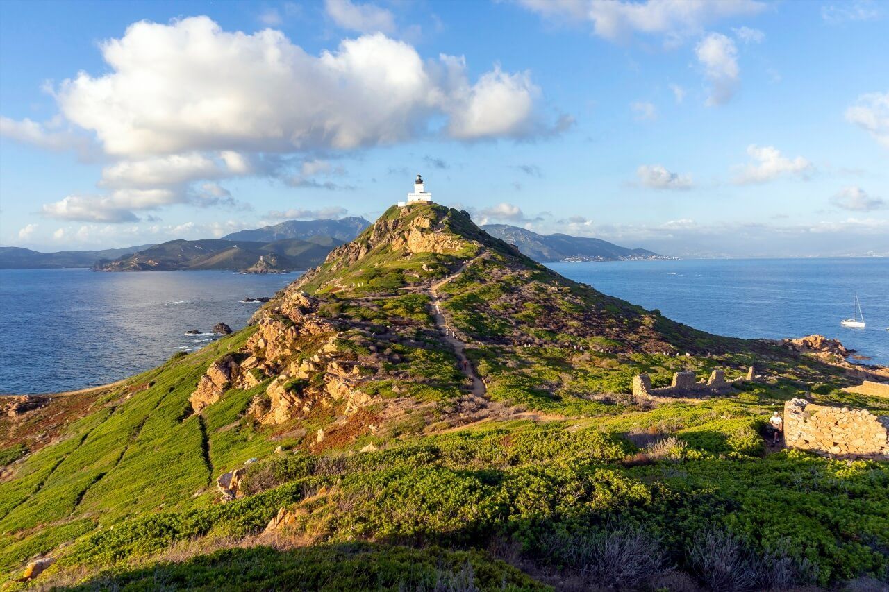
The Sanguinaires Route and the Sunset
At 15 kilometers west of Ajaccio, the Sanguinaires islands archipelago groups four red porphyry islets whose orange tint at sunset inspired the name, and not some bloody episode. The Grande Sanguinaire, the largest, houses a 19th-century lighthouse and the ruins of a 16th-century Genoese tower.
Common access is via the Sanguinaires route (D111), one of the island's most beautiful coastal roads: 15 kilometers of maquis, pebble beaches and pink rocks from Ajaccio, the sea to the left throughout the journey. The final viewpoint from Pointe de la Parata, where a Genoese tower stands facing the islets, is among the most photographed in Corsica. Boat excursions from Ajaccio marina allow approaching the islets and observing colonies of Audouin's gulls, a protected species uncommon in the Mediterranean.
Writer Alphonse Daudet dedicated a chapter of his Letters from My Windmill to these islets, after staying there several weeks in the 1860s. A cultural reference that adds a layer of depth to the panorama.
The Piana Calanques: UNESCO World Heritage Seen from the Inside
The Piana calanques are part of the Porto gulf, inscribed on the UNESCO World Heritage list since 1983. The inscription is doubly rare: it simultaneously classifies a terrestrial natural site and a marine site in the same area. The calanques proper are red porphyry formations carved by millions of years of erosion into arches, needles, corridors and amphitheaters that overlook a sea whose color changes from deep blue to turquoise depending on time and sky.
The D81 road between Piana and Porto constitutes the classic itinerary: 13 kilometers of hairpin turns above the rock formations, with several developed viewpoints (paid parking in season, 2 euros approximately per hour). Two or three stops suffice to understand the site's scale, but the vision from the road remains partial.
To see the site in its full dimension, two options: the Capo Rosso trail (Route du Capo Rosso, 20115 Piana, rated 4.3/5 on Google for 417 reviews), accessible from the parking of the same name, reaches the summit in 2h30 round trip and gives a plunging view of the calanques from a Genoese tower perched at 331 meters. It's from there that you understand the site's real extent, the rock formations extend over several kilometers of coast, the village of Piana appears on its hill in the background, Porto and its Genoese tower on the right. The other option is the boat from Porto: the perspective from the bottom of the cliffs is entirely different from the road, you see the formations overhanging the water, the marine caves at the foot of the rocks. Excursions last about two hours, departures from Porto marina.
Light radically transforms the porphyry color. Brick red at noon, almost purplish at 5pm, orange in the twenty minutes following sunset. If you're photographing, plan to be at the viewpoints between 6pm and 8pm in July: tourist buses have left, the light is golden, the rocks turn deep orange. It's at these moments that the Piana calanques fully deserve their classification.
The village of Piana itself, at 424 meters altitude, is often crossed without stopping. Wrongly: its pink stone alleys, its 18th-century baroque church and its colorful houses form an authentic Corsican village setting that few guides mention. A coffee on the central terrace, facing the valley, puts the day in perspective.
Logistics: the Piana calanques naturally combine with the Porto gulf in the same day, the two sites are 13 kilometers apart and read as a geographical continuum. From Ajaccio, count 1h15 by road to Piana.
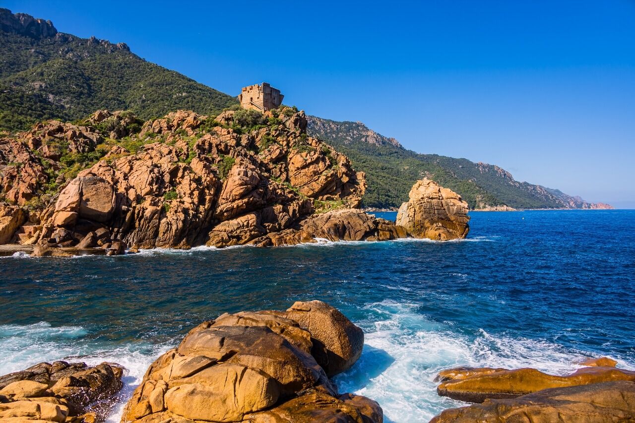
The Porto Gulf and Scandola Reserve
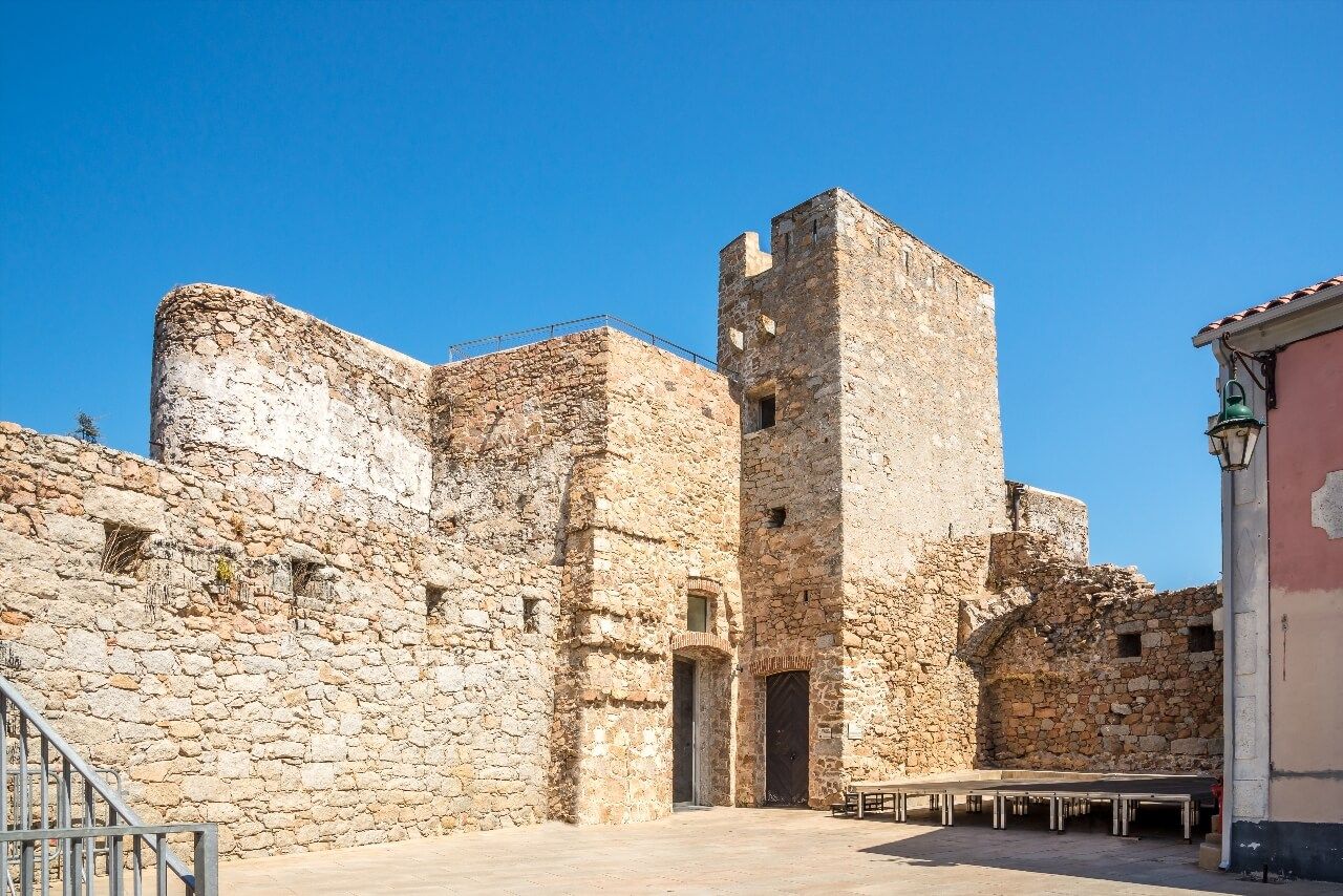
Porto is a village of a few hundred permanent inhabitants installed at the bottom of one of the most photographed gulfs in the Mediterranean. The Porto Genoese tower (Marine de Porto, 20150 Porto, rated 4.2/5 on Google for 104 reviews), built in the 16th century on a red porphyry rock at the gulf entrance, is one of the best preserved of the network of coastal towers that Genoa erected along the Corsican coast to watch for Barbary raids. Corsica had more than 90 in the Genoese period, about fifty remain today.
Porto marina is the departure point for excursions to the Scandola nature reserve, accessible only by sea, north of the gulf. French nature reserve since 1975, Scandola has been classified as UNESCO World Heritage since 1983, within the entire Porto gulf (Piana calanques, Girolata gulf, Scandola reserve). Its waters shelter large groupers, bottlenose dolphins and crested cormorants, its volcanic cliffs in green and ochre tones contrast with the red porphyry of neighboring calanques. Boat excursions from Porto generally combine Scandola and the Girolata calanques in one day: count 45 to 55 euros per person, half-day navigation.
From the road descending from Piana, the Porto gulf presents itself like an image printed with too high saturation: the red of the rocks, the dense blue of the sea, the dark green of the maquis, the white of the few houses. It's not a photographic effect, it's the site's reality.
The Bavella Needles: Beyond the Viewpoint
The Bavella needles massif, in the hinterland between Zonza and Solenzara, is one of the most photographed landscapes in Corsica and one of the least truly explored. Most visitors stop at the Bavella pass (Col de Bavella, 20124 Zonza, rated 4.7/5 on Google for 613 reviews) (1,218 meters), photograph themselves in front of the red granite needles and leave for the coast. Those who stay two more hours access something entirely different.
The needles proper form a crest of red granite teeth whose summits exceed 1,800 meters: the Punta Alta, the chain's highest point, reaches 1,855 meters. The trail leaving the pass northwest toward the Paliri refuge reaches in 40 minutes of walking the natural pools of Purcaraccia: basins carved in granite rock by torrents, with water at about 15°C in July. Attendance is heavy in high season but much more manageable than on the coastal beaches. Leaving before 9am or after 4pm significantly reduces attendance.
The laricio pine forest framing the needles is one of France's last primary forests. Some trees exceed 500 years of age and reach 45 meters in height. It burns regularly during Corsican summer fires: some areas bear traces of recent fires, charred trunks standing between new shoots, a contrasted landscape between destruction and regeneration that standard tourist guides rarely document.
From the pass, the road descending toward Solenzara on the east side offers panoramas over the entire eastern coast of Corsica: it's a less traveled axis than the Calanques route, but the descent is spectacular, about 45 minutes to the sea with successive hairpin turns dominating the void.
Access: the forest road D268 is open from May to late October. It can be cut after violent storms, check conditions before leaving. In July-August, a shuttle service connects the village of Zonza to the pass to avoid parking problems that block cars from 10am in the morning.
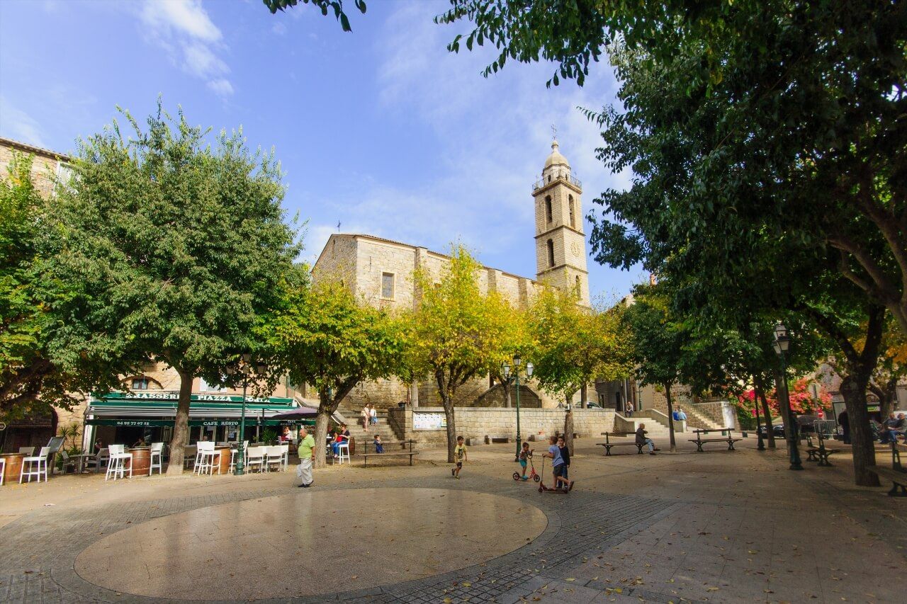
Sartène, the Most Corsican of Corsican Cities
The expression belongs to Prosper Mérimée, inspector of historical monuments who traveled Corsica in 1839, and it still holds. Sartène (Place Porta, 20100 Sartène, rated 4.4/5 on Google for 3,600 reviews) is organized around Place Porta, framed by dark granite houses with austere facades, without concession to easy pittoresque. The beauty is there, but it demands you give it time.
The upper town, perched at 310 meters, dominates the Rizzanese valley and the Sartenais hills. The staircase alleys of the Santa Anna district concentrate the oldest houses, some dating from the 15th century with their granite relieving arches spanning the passages. The Museum of Corsican Prehistory and Archaeology, housed in the former Genoese governors' palace, holds national-level collections from Cucuruzzu and Capula excavations: menhir statues, ceramics and bronze objects from the Neolithic and Iron Age. Entry 4 euros.
The Catenacciu procession, on Good Friday evening, is one of the most impressive religious ceremonies in France: a chained penitent carrying a 30-kilo cross walks barefoot through the upper town alleys from nightfall to dawn, followed by hundreds of faithful in red hoods. The penitent's identity remains secret until his death. The tradition dates back to the 15th century and has not been interrupted since, except during the two world wars. If your stay coincides with Holy Week, Sartène alone is worth the detour.
The city is also the capital of a hinterland territory, the Sartenais, which conceals several of the least frequented sites in Southern Corsica, granite villages, centennial olive groves and first-order archaeological sites.
Propriano and the Valinco Gulf
Propriano is the main town of the Valinco gulf, one of the least touristic gulfs in Southern Corsica despite landscapes comparable to the more famous gulfs of the north of the island. The town of 3,600 inhabitants has a commercial port, a fine sand beach on the waterfront and direct access to several beaches of the back gulf.
The Valinco gulf opens on 20 kilometers of coastline between Campomoro point to the south and Porto-Pollo point to the north. The Campomoro beach, at 15 kilometers from Propriano, is guarded by a 16th-century Genoese tower and gives access to a remarkable snorkeling site in the posidonia seagrass meadows. Further north, the Capo di Muru coves are accessible by a coastal path from Porticiolo village: one hour walk for beaches almost deserted even in mid-July.
Propriano serves as a coherent base to explore toward Sartène (20 minutes), the archaeological sites of Alta Rocca (1 hour) and Bonifacio (1h15). It's the most convenient central position in southwest Southern Corsica for those who want to cover several sites without returning each evening to Porto-Vecchio or Ajaccio.
Alta Rocca: Cucuruzzu and the Lady of Bonifacio
The Alta Rocca is the mountainous plateau that constitutes the hinterland between Sartène, Zonza and Levie. A territory apart, with its chestnut forests, granite hamlets and prehistoric sites among the best preserved in all the western Mediterranean. Most tourists who visit Southern Corsica don't go this far. It's precisely what makes it one of the most memorable destinations for those who dedicate a day to it.
The site of Cucuruzzu (or Capula), near Levie, is a castéddu from the Bronze Age, a dry stone fortification built around 1500 BC, perched on a granite rock above a pubescent oak forest. The state of preservation is exceptional: walls still reach 3 to 4 meters high in some sections, interior rooms are readable, circulation corridors between areas still identifiable. The guided tour (included in the 5 euros entrance) lasts about 45 minutes and helps understand the fortification's organization. Plan for closed hiking shoes: the marked 1.5-kilometer trail from parking crosses a forest with irregular rocks.
The village of Levie, at 700 meters altitude, houses the Alta Rocca Museum. It's there that the Lady of Bonifacio is exhibited, skeleton of a woman of about 8,500 years old, discovered in a cave near Bonifacio in 1972. One of the oldest human skeletons found in Corsica, in a sufficient state of preservation to allow reconstruction of the period's way of life. The room dedicated to her is sober, without dramatic effects, the presentation lets the facts speak.
The village of Sainte-Lucie-de-Tallano, at 12 kilometers from Levie, is known for its olive grove: centennial olive trees produce AOC Corsica olive oil cold-pressed in the village cooperative mill. The Saint-Jean-Baptiste church and its 16th-century Franciscan convent constitute most of the built heritage. Both villages combine in a half-day from Sartène.
When to Go and How to Organize
May, June and September offer the most favorable conditions for visiting Southern Corsica: the sea reaches 22 to 25°C from June and 26 to 28°C in September, most natural sites are accessible (Bavella pass open, Lavezzi excursions available), and attendance is 40 to 50% lower than July-August peaks. July and August concentrate maximum temperatures, up to 38°C in interior valleys, and complete saturation of the most famous beaches.
A car is essential. Rapides Bleus interurban buses connect Ajaccio to Bonifacio, Porto-Vecchio and Sartène, but schedules are limited and interior natural sites (Bavella, Alta Rocca, Piana calanques) are not served. Car rental should be booked before departure in high season, stocks run out quickly.
For itinerary organization, three departure bases work well according to priority areas:
- Bonifacio for the south (Lavezzi, Porto-Vecchio, Rondinara, Figari)
- Ajaccio for the northwest (Sanguinaires, Piana calanques, Porto gulf), and to discover the capital with the Ryocity of Ajaccio, 18 audio-guided points of interest
- Propriano or Sartène for the hinterland (Alta Rocca, Cucuruzzu, Sartenais villages)
A stay of 7 to 10 days allows covering the essentials without rushing. Below 5 days, it's better to deepen one area than run between all.
FAQ
What Is the Best Time to Visit Southern Corsica?
May, June and September are the most recommended months. The sea is swimmable from the end of May (20°C), reaches its maximum in August (28°C) and remains pleasant until October (23-24°C). In July and August, the most famous beaches (Palombaggia, Santa Giulia) are crowded from 10am and the narrow roads of the interior can be blocked. June and September allow you to enjoy the same sites with approximately half the crowds.
How to Get Around Southern Corsica Without a Car?
It's difficult, but not impossible for the coast. Interurban bus lines (Rapides Bleus) connect the main towns: Ajaccio-Bonifacio, Ajaccio-Porto-Vecchio, Ajaccio-Sartène. In summer, tourist shuttles serve some natural sites like the Bavella pass from Zonza. However, the Piana calanques, Alta Rocca, the Sanguinaires route and most secondary beaches are inaccessible without a vehicle. Car rental at Figari airport (south) or Ajaccio remains the most efficient solution.
How Many Days Should You Plan for Southern Corsica?
7 to 10 days is the ideal duration to cover the main sites without rushing. A minimum of 5 days is necessary to see Bonifacio, the southern beaches, Ajaccio and its surroundings. Less than 5 days, it's better to choose an area and explore it in depth rather than running from one end to the other of a region that extends over 250 kilometers of coastline.
Are Southern Corsica Beaches Paid?
Swimming is free on all beaches. Parking is often paid in high season (2 to 8 euros depending on the site). Access to the Lavezzi islands involves paying for the boat crossing (25 to 35 euros per person round trip), which de facto includes access to the nature reserve. Some more secluded beaches remain free even for parking, especially those accessible only on foot.
Can You See Southern Corsica Starting from Bastia?
Technically yes, but the journey from Bastia to Bonifacio takes 3 to 3h30 via the national road, and the interior roads take even longer. If you arrive by ferry in Bastia, you can discover Upper Corsica on the way, the Ryo audio guide tour of Bastia covers 21 points of interest in 1h30 in the old port and Terra Vecchia. But for Southern Corsica proper, starting from Ajaccio or Figari airport is much more geographically coherent.
What Are the Hiking Sites Accessible Without Being an Experienced Hiker?
Several major sites are accessible to occasional walkers. The natural pools of Purcaraccia from the Bavella pass (40 minutes one way, marked trail, no difficult elevation). The Parata point and the view of the Sanguinaires islands (15 minutes from parking). The Tamaricciu beach trail from Palombaggia (20 minutes). The Cucuruzzu site (1.5 km forest trail from parking, 45 minutes). However, the complete ascent of Capo Rosso (2h30 round trip) and the GR20 require a higher level of hiking.
Southern Corsica doesn't reveal its best moments to those who stay on the coast. The 14 sites to do in Southern Corsica gathered in this guide intentionally cover several registers, from the coastline to the hinterland, from the white cliffs of Bonifacio to the laricio pine forests of Bavella, because it's the combination of both that makes a stay here unforgettable. The beaches of Palombaggia and the Lavezzi islands attract crowds, and rightly so. But Cucuruzzu, Sartène and the Valinco gulf remain accessible to those who rent a car and allow themselves one or two days without the sea. To start with the capital before exploring the rest of the region, the Ryo audio guide tour of Ajaccio is the most efficient starting point: 18 audios, 6 kilometers of commented walk in the streets of the imperial city, at your own pace.