Créé par Romane, le 20 juin 2026
Votre guide Ryo
Atlas Mountains of Morocco: The Complete Guide for an Unforgettable Hike (2026)
© Shutterstock
The Atlas Mountains are like no other. Two hours from Marrakech, the snowy peaks of the High Atlas dominate deep gorges and ocher clay villages, a landscape that takes your breath away before you even lace up your boots. This 2,400-kilometer-long massif crosses Morocco, Algeria and Tunisia, but it's in Morocco that the Atlas Mountains reach their most spectacular dimension, with Djebel Toubkal at 4,167 meters, the highest peak in North Africa.
This guide takes you through the three main massifs, High Atlas, Middle Atlas, Anti-Atlas, with altitude data, the most beautiful hiking routes, Berber villages not to miss and all the practical advice to organize your stay. Whether you're planning a technical ascent of Toubkal, a family walk among cedars and waterfalls, or a 4×4 excursion from Ouarzazate, you'll find here the information that's lacking in most online guides. And if the desire for other mountains takes you afterwards, the Ryo app offers audio-guided tours like the audio guide of La Orotava, a city on the volcanic slope of Tenerife island.
Atlas Overview: Geography, Altitudes and Massifs
The Atlas Mountains are one of the largest chains in the western hemisphere. Over a total length of 2,500 kilometers, they extend from southern Morocco to Cape Bon in Tunisia, crossing Algeria along the way. In Morocco, they divide into four distinct geographical entities, each with its own altitude, climate and population characteristics.
The High Atlas is the best-known and highest massif. It runs east to west for 700 kilometers from the Algerian border to the Atlantic, forming a natural barrier separating Atlantic Morocco from Saharan Morocco. Its peaks regularly exceed 3,000 meters, and a dozen culminate above 4,000 meters.
The Middle Atlas unfolds in the northeast, between Fès and Meknès. Less spectacular in altitude, its highest point, Jbel Bou Naceur, reaches 3,340 meters, it compensates with exceptional vegetation: the Atlas cedar forests, among the most beautiful in North Africa, shelter the last populations of Barbary macaques.
The Anti-Atlas extends south and southwest, between Taroudant and Tata. More arid, more mineral, it constitutes the natural transition between the green mountains of the High Atlas and the Sahara Desert. Its highest point, Djebel Aklim, reaches 2,531 meters.
Finally, the Eastern High Atlas connects the main High Atlas to the Jbel Saghro massif, in the Tinghir and Errachidia region. Less frequented by Western hikers, it offers landscapes of vertiginous gorges, the Dadès gorges and Todgha gorges, among the most photographed in Morocco.
The Moroccan Atlas Mountains shelter 5 million Berbers (Amazigh) spread across thousands of altitude douars (villages). Their pastoral way of life, adobe architecture and legendary hospitality constitute a cultural dimension as strong as the natural spectacle.
High Atlas: The Roof of Morocco Around Marrakech
Marrakech is the obvious gateway to the High Atlas. The Ourika Valley, 60 kilometers south of the red city, has welcomed first visitors since the early 20th century: a road winds between palm trees and raw earth villages to the Setti Fatma waterfalls, a pilgrimage and bathing place frequented by Moroccan families on weekends.
Further northeast, the Zat Valley remains largely preserved from mass tourism. Shepherds still practice transhumance with their flocks of sheep and goats between high-altitude pastures in summer and low mountain villages in winter. A two-day hike from the village of Aït Aïssa allows you to cross grandiose landscapes without encountering other hikers.
The Tichka Pass road (Province of Ouarzazate, Morocco, rated 4.5/5 on Google for 481 reviews) (2,260 m) is the main axis connecting Marrakech to Ouarzazate and the gates of the desert. Even without stopping to hike, this 200-kilometer journey is an experience in itself: the bends follow one another between ocher rocky walls and villages clinging to the flanks, with plunging views over valleys where water still flows.
On the north side of the High Atlas, the Aït Bougmez Valley (Tabant, Province of Azilal, Morocco, rated 4.5/5 on Google for 137 reviews), nicknamed "the happy valley", deserves several days. Wide, fertile, framed by peaks exceeding 3,700 meters, it attracts hikers from around the world for its 5 to 10-day circuits between mountain refuges and bivouacs. The village of Tabant (1,800 m) serves as a base: you'll find decent guesthouses, some grocery stores and muleteers who offer their services to carry bags.
The Mgoun Massif (4,071 m), one of Morocco's highest peaks, is located in this zone. Its complete traverse, 8 to 12 days depending on pace, is considered one of the great mountain hikes of the Arab world: passes above 3,500 meters, gorges impassable on horseback, nights under the stars in valleys without electricity.
For families or inexperienced hikers, the Ourika valley between Aghbalou and the Setti Fatma waterfalls offers accessible walks on well-marked trails, with possibilities to lunch in stilt inns above the wadi. Most Marrakech agencies offer this day trip for about fifty euros per person.
Attention to calendar: between December and March, High Atlas passes (Tichka, Aït Benhaddou) can be closed after heavy snowfall. High-altitude hikes require winter equipment (crampons, ice axe) before June and after September above 3,500 meters.
Middle Atlas: Cedar Forests and Mountain Lakes
Azrou is the entry point to the Middle Atlas for those coming from Fès or Meknès. This small Berber town at 1,250 meters altitude is surrounded by century-old cedar forests where Barbary macaques live, the only wild primate species on the African continent outside sub-Saharan Africa. The monkeys are accustomed to visitors and let themselves be approached, but be careful not to feed them, which disturbs their natural diet.
A few kilometers away, Ifrane always surprises new visitors: this colonial town in alpine style, built in the 1930s by the French Protectorate, resembles a Swiss resort more than a Moroccan city. It houses Morocco's main ski resort, Michlifen, which opens from January to March when snow conditions permit. The slopes remain modest compared to the Alps or Pyrenees, the maximum vertical drop is about 400 meters, but the experience of skiing in Morocco remains an appreciable curiosity.
The Middle Atlas Lakes constitute another major attraction. Lake Aguelmame Sidi Ali (2,000 m) is one of Morocco's largest natural lakes: its cold, turquoise waters are surrounded by cedar and juniper forests. Further north, Lake Aguelmame Azegza offers a wilder setting, accessible by 4×4 track from Khenifra.
Hikes in the Middle Atlas favor mid-mountain circuits between 1,500 and 2,500 meters, ideal for families or hikers who want to avoid high altitudes. The trail around Ain Leuh crosses plateaus of flowering broom in spring and springs that bubble at the foot of cedars. To see Morocco's highest falls, you have to go further southwest, to the Ouzoud waterfalls (110 meters of fall over three levels), 15 kilometers from Azilal, already in the central High Atlas.
The Middle Atlas is also horse country. Local studs organize equestrian circuits of 2 to 5 days through forests and Berber villages, a way to discover the Atlas Mountains at a different pace.
Note an often ignored fact: the Middle Atlas is Morocco's water tower. Its lakes and groundwater feed the great rivers that irrigate the central plains, Oum Er-Rbia, Moulouya, Sebou. The preservation of its forests is therefore an issue well beyond mountain tourism.
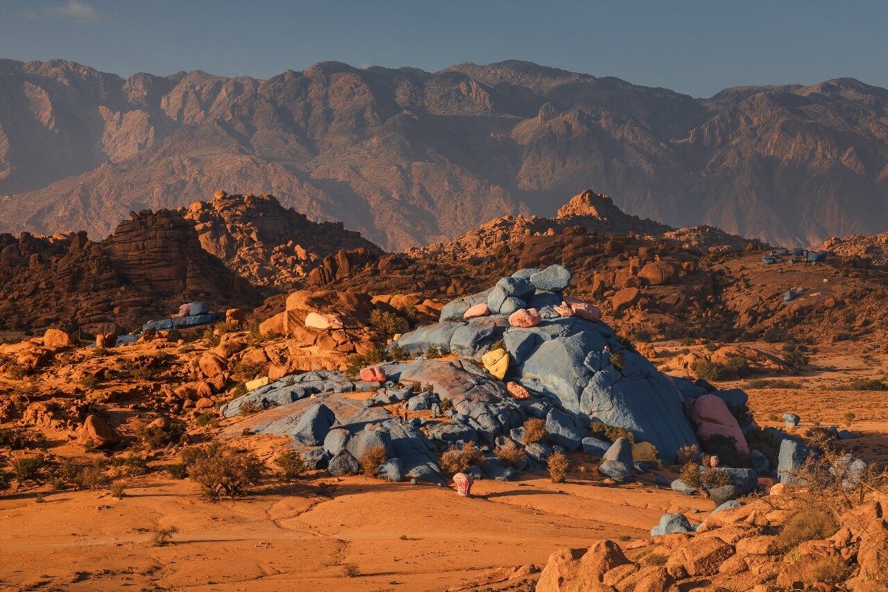
Anti-Atlas: Desert, Argan and Perched Villages
The Anti-Atlas is the least known chain to tourists, and paradoxically one of the most spectacular. It extends over more than 700 kilometers between Agadir in the west and Figuig in the east, culminating in the Ameln valley (Tafraout, Province of Tiznit, Morocco, rated 4.5/5 on Google for 34 reviews) and around Tafraout where pink granite rocks form geological formations unique of their kind.
Tafraout is the informal capital of the Anti-Atlas. Perched at 1,200 meters in a basin surrounded by granite monoliths, this lively town offers a dozen marked hiking circuits between palm trees, almond trees and dry stone villages. The best time: February, when almond trees are in bloom and temperatures remain mild.
The Ameln Valley concentrates about twenty Amazigh villages whose ocher clay houses blend into the mountain. The village circuit, a 4 to 6-hour walk depending on pace, crosses terraced agricultural terraces, springs captured in seguias (irrigation canals) and collective granaries (agadirs) built high to protect harvests.
Further east, the Tata gorge and Foum Zguid oases mark the transition between mountain and desert. Camel treks are practiced here in reg landscapes (stone desert) with the Anti-Atlas foothills as backdrop. The dawn light on these purple ridges is worth getting up at five o'clock.
The Anti-Atlas also conceals Morocco's most beautiful rock engravings: the sites of Foum Chenna and Aït Herbil preserve representations of elephants, rhinoceros and giraffes engraved in sandstone several millennia ago, witnesses of a once verdant Sahara. These prehistoric testimonies add an archaeological dimension to hiking that most competitors almost all ignore.
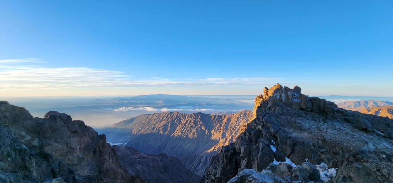
Djebel Toubkal: Ascending the Highest Peak of North Africa
The Djebel Toubkal (4,167 m) is the objective of thousands of hikers each year. Its proximity to Marrakech, just 70 kilometers, and its relative accessibility (no technical climbing in summer) make it one of the most climbed "4,000s" in the world. But don't underestimate the effort: the positive elevation gain of the classic ascent from Imlil exceeds 2,200 meters over two days.
The classic two-day route:
Day 1, Imlil (1,740 m) to Toubkal Refuge (3,207 m) via the village of Aremd and the Aït Mzik gorges. Allow 5 to 6 hours walking for 1,467 meters of elevation gain. The CAF refuge (French Alpine Club) can accommodate 70 people; advance booking essential in July-August.
Day 2, Departure refuge at 6:00 AM, ascent via northwest ridge to summit (2.5 to 3 hours depending on fitness). The summit view on clear days extends to the Erg Chebbi dunes in the east and, in exceptionally clear weather, to the Spanish coasts in the north. Descent to Imlil via the same route or via the Azzaden gorges (longer, more varied).
Variants and alternatives:
- Toubkal circuit in 3 days via Tizi n'Ouanoums pass (3,664 m): more picturesque, less crowded
- Winter ascent (November-May): crampons and ice axe mandatory, guide highly recommended
- Imlil-Oukaïmeden traverse: 3 days, passes by Lake Ifni at 2,295 meters, one of Morocco's most beautiful mountain lakes
Necessary equipment: waterproof high hiking boots, walking poles, warm clothes for the night at the refuge (it freezes even in summer at 3,200 meters), 50+ SPF sunscreen (altitude amplifies UV radiation), minimum two liters of water per person.
The physical preparation is serious: it's better to have done at least two or three hikes of 800 to 1,000 meters elevation gain in the preceding weeks. People suffering from heart or respiratory problems should consult a doctor before planning the ascent.
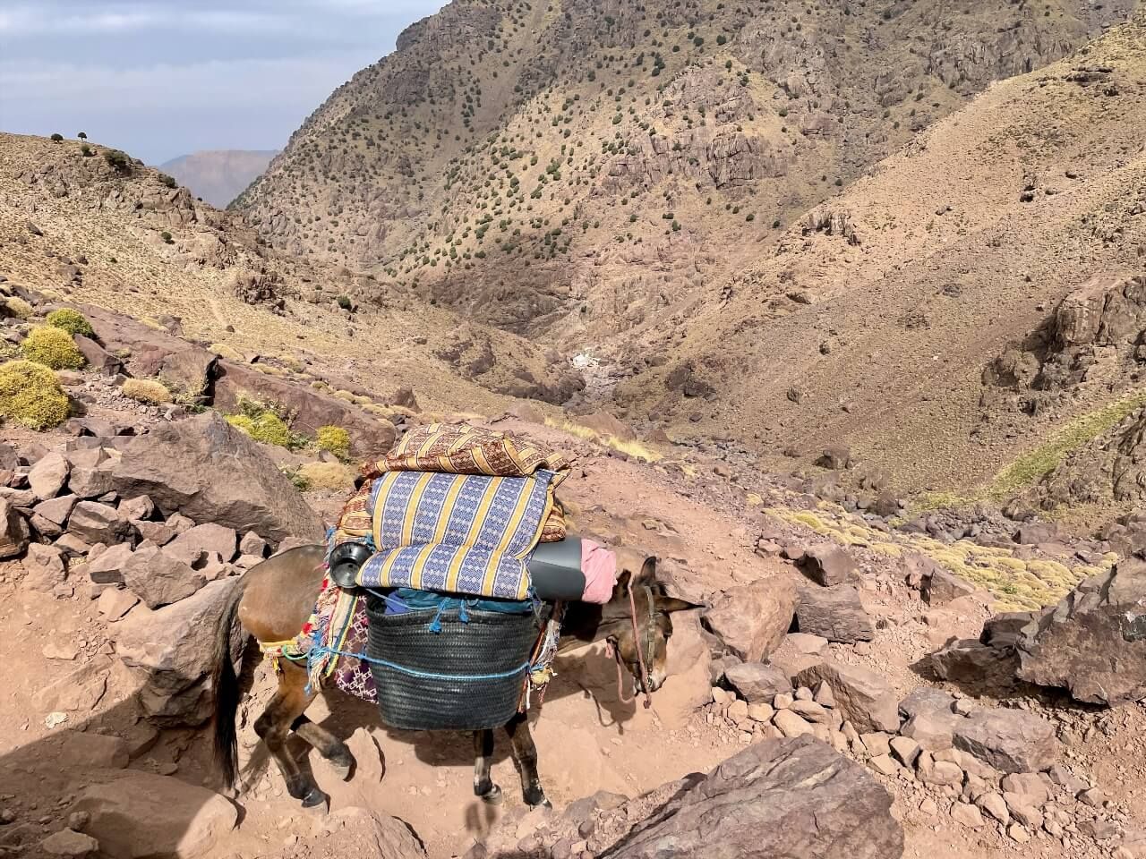
A cultural note to finish: the village of Imlil itself deserves half a day. Its Berber women's cooperative produces essential oils and natural cosmetics. The village mosque, sober and white, can be photographed from outside. And the mules that carry bags and supplies to the refuge are part of the landscape, their use supports about ten village families year-round.
Best Hikes in the Atlas Mountains
Beyond Toubkal, the Atlas Mountains offer a catalog of hikes ranging from easy to very difficult, from the most frequented massifs to almost virgin valleys.
1-day circuits (easy to intermediate):
The Ziz valley from Midelt: 12-kilometer descent through red basalt gorges, with view of the fluvial oasis below. Moderate elevation: 400 meters. Accessible from age 8.
The Setti Fatma waterfalls circuit: 3 hours round trip from the Ourika valley terminus. Seven waterfalls in easy climbing on rocks well equipped with ropes and rungs. Distance: 8 kilometers, elevation: 250 meters.
The gardens of Ouirgane: family hike in a century-old olive grove, argan and almond trees, with lunch at a Berber farm. Distance: 6 kilometers, flat. Ideal for a first contact with Berber countryside.
2-3 day circuits (intermediate):
The Aït Bouguemez valley traverse: 45 kilometers over three days, between 1,800 and 3,200 meters, with nights in guesthouses in villages. A condensed version of the best rural Atlas has to offer.
The Djebel Sirwa loop (3,304 m): less famous than Toubkal, this volcanic peak of the eastern Anti-Atlas offers panoramas over the desert and Atlas. Three days, guide recommended for off-trail passes.
The Todgha gorges from Tinghir (Tinghir, Province of Tinghir, Morocco, rated 4.7/5 on Google for 218 reviews): a hike in one of the world's most vertical gorges, with 300-meter walls rising just meters from each other. Accessible in one day from Ouarzazate.
7-14 day circuits (difficult, for experienced hikers):
The Atlas traverse: from Taroudant to Marrakech over 200 kilometers, crossing six passes above 3,000 meters. The reference long-distance hike in Morocco, still little known despite its exceptional quality.
The Mgoun tour: 10 to 12 days around one of the country's highest peaks, through gorges and villages that didn't see their first tourist until the late 1990s. Local guide is essential here.
For lovers of audio-guided hikes in other mountain ranges, the Ryo app offers the audio guide of La Orotava, a city on the volcanic slope of Tenerife island, which explores an equally striking mountain geography from a historical and cultural perspective.
Alternative Excursions: Camels, Mountain Biking, 4×4 and Hot Air Balloon
Walking is not the only way to explore the Atlas Mountains. For those who prefer other modes of transport, or who want to vary pleasures throughout a stay, several remarkable alternatives exist.
Camel rides are practiced mainly in foothill areas, between the last palm groves and the first mountain foothills. The classic outing from Ouarzazate or around Zagora lasts between one and three hours, through stone desert landscapes dotted with alfa tufts. For more complete immersion, two-day bivouacs allow you to spend a night under the stars at the entrance to the Dadès gorges.
Mountain biking has been growing notably in the High Atlas for the past ten years. The most renowned route connects Tichka pass to Ouarzazate on an 80-kilometer track with 1,800 meters of cumulative descent, a full day of gravel and sandy passages with a few short technical portages. Several Marrakech agencies rent quality mountain bikes and organize shuttles in the opposite direction.
4×4 outings from Marrakech or Ouarzazate allow access to areas inaccessible on foot in one day: the ridge track between Aït Ben Haddou (Province of Ouarzazate, Morocco, rated 4.7/5 on Google for 18K reviews) and Boutaghrar offers 360° views over the High Atlas and the beginning of the desert.
Hot air ballooning above the Atlas is a unique experience. Flights depart from Marrakech at sunrise: the balloon flies over the first foothills of the High Atlas and the Ourika palm groves in golden light. Flight duration is about one hour; prices start at 250 euros per person. Choose a provider member of the Moroccan Federation of Free Ballooning for serious safety guarantees.
Horseback riding in the Middle Atlas around Azrou and Ifrane offers outings from one to five days in cedar forests. Barb horses, a robust local breed adapted to mountainous terrain, ensure comfortable riding even on rocky tracks.
For climbing enthusiasts, the Todgha gorges welcome climbers from around the world attracted by 200 to 300-meter routes on limestone, graded from 4 to 8c. A basic campsite at the foot of the gorges allows multi-day organization.
Atlas Berber Villages
Berber villages are the soul of the Atlas. Built of adobe or dry stone on rocky spurs that commanded passes and valleys, they testify to millennial vernacular architecture and know-how transmitted from generation to generation.
Aït Ben Haddou is the most famous, classified as UNESCO World Heritage since 1987. Its ksar (fortified village) in raw earth has served as a backdrop for dozens of Hollywood productions, from Gladiator to Game of Thrones. While overcrowding is real in high season, an early morning or late afternoon visit remains a powerful experience.
Tinerhir (Province of Tinghir, Morocco, rated 4.4/5 on Google for 3.1K reviews) is the gateway to the Todgha gorges. Its 40-kilometer palm grove, irrigated by seguias (canals) dug centuries ago, still produces dates and figs. The adobe houses with facades decorated with geometric motifs constitute one of the most beautiful examples of Berber architecture in the region.
In the Aït Bouguemez valley, the villages of Tabant, Agouti and Rbat form a network inhabited for a long time, as testified by the high collective granaries (ighrem) still in use for some. Ethnologist Jacques Berque extensively described these communities in his works on Berber societies of Morocco.
Tansghart, in the Anti-Atlas 30 kilometers from Tafraout, is one of the region's best-preserved villages: its dry stone granaries on vertical rocks, narrow streets and central fountain have remained virtually identical for generations. A café run by a local family offers mint tea and Berber pancakes (rghaïf) for a few dirhams.
Weekly village markets (rural souks) are the best times to observe local life without intrusion: selling vegetables, spices, wool crafts, loud transactions in several languages (darija, tamazight, and sometimes tifinagh for the most isolated communities).
Where to Stay in the Atlas: Guesthouses, Kasbahs and Bivouacs
Accommodation in the Atlas Mountains covers a very wide spectrum, from sleeping in a sleeping bag under the stars to nights in high-comfort guesthouses.
The stage guesthouses are the basic option for hikers. Managed by Berber families trained by the Moroccan Ministry of Tourism, they offer a simple room (2 to 8 beds), evening meal (tajine on fixed menu) and breakfast (bread, argan oil, jam, mint tea) for 150 to 250 dirhams per person (15 to 25 euros). Quality varies but the welcome is systematically warm.
At Imlil, Toubkal departure base, ten guesthouses have formed a network. The best known, Gîte Toubkal, run by the same family for three generations, offers clean dormitories at 100 dirhams per night and private rooms at 300 dirhams. Phone booking essential in high season (July-August).
The CAF Toubkal Refuge (3,207 m) is managed by the French Alpine Club and the Royal Moroccan Ski and Mountain Federation. It has dormitories (60 places) and a dining room where the guardian prepares hot meals. Rate: 130 dirhams per bed (about 12 euros). Online booking mandatory from May to September.
For a more luxurious experience, the guest kasbahs of the Ourika valley and Ouarzazate offer rooms between 80 and 250 euros per night, with pool, spa and Moroccan gastronomic cuisine. Kasbah Tamadot (Asni, Province of Al Haouz, Morocco, rated 4.8/5 on Google for 548 reviews) is the most renowned, with its rooms in authentic adobe buildings and views over the snowy peaks of the High Atlas.
In the Aït Bougmez valley, guesthouses, often simple family houses with a few extra beds, constitute the most authentic option. No online booking sites: contacts are found via Beni Mellal tourism offices or via trekking agencies based in Marrakech.
The bivouac is legal and widely practiced in the Moroccan Atlas Mountains. Outside protected areas (Toubkal National Park), no authorization is required to sleep under the stars. Local shepherds generally tolerate tents in their pastures provided no fire is lit (fire risk) and waste is collected.
Finally, for organized multi-day circuits, trekking agencies based in Marrakech offer all-inclusive packages including guides, muleteers, camping equipment and field cooking. Rates vary from 60 to 150 euros per person per day depending on comfort level.
Maps and Practical Itineraries to Organize Your Stay
The Moroccan Atlas Mountains extend over more than 600 kilometers from east to west in Morocco alone: good cartographic organization is essential to avoid spending five hours on a bus between two treks.
Morocco's topographic maps are published by the National Documentation Center at 1:50,000 scale (very precise, ideal for hiking) and 1:100,000 scale. These maps are available at Al Manar bookstore in Marrakech (Avenue Mohamed V) and in several specialized bookstores in Rabat and Casablanca. The High Atlas series covers the Toubkal/Mgoun zone in several sheets.
The Maps.me app (offline) is widely used by hikers in the Atlas: it integrates mountain trails with a level of detail often superior to Google Maps for remote areas. OpenStreetMap, on which Maps.me is based, benefits in the Atlas from substantial collaborative mapping work over several years.
Main itineraries by departure base:
- From Marrakech (2-3h drive): Toubkal, Ourika valley, Aït Bougmez, Tichka pass, Aït Ben Haddou
- From Agadir (1-2h): Anti-Atlas and Tafraout, upper Draa gorges
- From Fès/Meknès (1-2h): Middle Atlas, Ifrane, Azrou, mountain lakes
- From Ouarzazate (30 min to 3h): Dadès gorges, Todgha gorges, Djebel Saghro
Distances and travel times:
- Marrakech to Imlil (Toubkal): 90 km, 1h45 by car, 2h30 by shared minibus
- Marrakech to Ait Bougmez: 270 km, 5h by car
- Marrakech to Tinghir (Todgha gorges): 350 km, 5h30 by car
- Ouarzazate to Aït Ben Haddou: 30 km, 30 min
- Fès to Azrou: 70 km, 1h
Shared taxis (grands taxis) connect main cities to mountain departure points. Minibuses (CTM, Supratours) cover main routes. Car rental remains essential to access secondary valleys.
When to Go to the Atlas Mountains
Seasons in the Moroccan Atlas Mountains are well marked, and the choice of period largely determines the type of possible experience.
Spring (March-May): the best season for most hikers. Peaks are still snow-covered above 3,000 meters, valleys are green, almond and apricot trees are blooming in the High Atlas. Ideal temperatures between 15°C in valleys and 5°C at night at altitude.
Summer (June-August): conditions are excellent for high-altitude ascents, with stable weather windows of 8 to 10 consecutive days. Heat in valleys (35-40°C) makes low and medium mountain outings exhausting. July-August constitutes the high tourist season, crowded refuges, rising prices.
Autumn (September-November): the second good season. Temperatures at altitude are pleasant in September-October, autumn light on Berber villages is particularly beautiful, and attendance is much lower than summer.
Winter (December-February): reserved for equipped mountaineers above 2,500 meters. The Anti-Atlas and foothill areas remain accessible and very pleasant between 15 and 20°C during the day. The Michlifen resort opens its slopes in early January.
Hiking in the Atlas with a Local Guide: Why and How
The guide question divides hikers: some prefer to explore alone with map and GPS, others consider local professional accompaniment essential. In the Moroccan Atlas Mountains, arguments in favor of a guide are particularly solid.
Safety first: High Atlas trails are rarely marked according to European standards. Cairns (stone piles) guide on frequented routes, but fog or snowfall can make a trail invisible in minutes. Each year, several foreign hikers get lost in the Toubkal massif.
Cultural dimension: a local Berber guide opens doors literally closed to the solitary hiker. He speaks Tamazight (Berber) with shepherds, knows families who accept visitors for lunch, and can decode wall paintings, tattoos, carpet patterns that tell the history of valleys.
Local economic impact: engaging a local guide and muleteer directly supports mountain families whose income alternatives are limited. Standard rate is 300 to 500 dirhams per day for a guide (30-50 euros) and 200 to 250 dirhams for a muleteer with his mule.
To find a certified guide, the Moroccan National Tourism Office (ONMT) directs to approved mountain guide offices. Guide offices in Imlil and Tabant (Aït Bougmez valley) display official rates and available guide contacts.
In the same philosophy of guided exploration with historical context, the Ryo app offers the Ryo's audio-guided tour of The Crowned Mountain in Laon, an example of what the Ryo audio guide does in urban and semi-natural environments: guiding step by step through spaces that would otherwise deserve several hours of preliminary research.
Finally, the population's reception is an element not to neglect. In some isolated valleys (Zat, Bougmez, Aït Benhaddou), inhabitants haven't always welcomed disrespectful tourists well. Arriving via a local guide guarantees proper introduction and respect for local courtesy codes: asking before photographing, not entering houses without invitation, dressing appropriately.
What to Eat and Drink While Hiking in the Moroccan Atlas
Food while hiking in the Atlas is both simple and flavorful. Berber families who run guesthouses prepare hearty and nutritious meals at derisory prices.
The tajine is unmissable: simmered for two hours in an earthenware dish over embers, it can be chicken, vegetables and preserved lemon, or mutton with prunes. The price in a guesthouse: 50 to 80 dirhams (5 to 8 euros). Low-altitude tajines, prepared with garden vegetables, often have superior taste quality to those in Marrakech restaurants.
The Friday couscous is the festive meal. In villages crossed on Friday (holy day), it's not uncommon for a family to spontaneously offer to share their couscous with passing travelers, a gesture of hospitality not to be forgotten.
The Berber pancakes (msemen, rghaïf) with honey and argan oil constitute the typical breakfast. Argan oil, produced mainly in Souss-Massa and part of the Anti-Atlas, is an exceptional product protected by geographical indication.
For hiking picnics: dried figs, almonds, dates, local goat cheese and homemade bread constitute perfect energy ration. Marrakech supermarkets offer cereal bars and packaged almonds to complete.
The drinking water is the main concern. High-altitude springs are generally healthy but purification (chlorine tablets, Sawyer filter) remains advisable. In villages, tap water is drinkable in douars connected to the network, increasingly numerous. Never drink directly from a wadi downstream from a village.
FAQ
What Is the Highest Peak of the Atlas Mountains?
The Djebel Toubkal peaks at 4,167 meters in the Moroccan High Atlas, about 70 kilometers south of Marrakech. It is the highest summit in North Africa and the Arab world. The Djebel Mgoun, one of the country's highest peaks, reaches 4,071 meters in the Mgoun massif, east of Toubkal. The highest point of the Middle Atlas is Jbel Bou Naceur at about 3,340 meters.
Is the Moroccan Atlas Difficult to Hike Alone?
It entirely depends on the chosen route. Low-altitude walks (Ourika valley, Anti-Atlas around Tafraout) are accessible to inexperienced hikers and can be done without a guide using maps or a GPS app. However, ascents above 3,500 meters, Toubkal in particular, present real risks in bad weather or poor physical condition. A certified guide is strongly recommended for any high mountain outing, and mandatory in winter on snowy peaks.
What Is the Best Base for Hiking in the High Atlas?
Marrakech is the departure point for the vast majority of circuits in the High Atlas. The city is served by direct flights from Paris, Lyon, Bordeaux, Nantes and about fifteen other French cities, with fares often below 100 euros round trip in low season. From Marrakech, shared taxis allow you to reach Imlil (Toubkal base) in 2 hours for about 200 dirhams. For the Middle Atlas, Fès or Meknès constitute the natural logistical bases.
Do You Need a Visa to Travel to Morocco from France?
No. French citizens do not need a visa to enter Morocco. A valid passport is sufficient for a tourist stay up to 90 days. Morocco is one of the most accessible foreign destinations for the French, without prior administrative procedures.
Where to Find a Map of the Atlas Mountains?
The topographic maps at 1:50,000 and 1:100,000 scale from the National Documentation Center (CND) cover the entire Moroccan Atlas massif. They are available at Al Manar bookstore in Marrakech and in a few specialized bookstores in Paris. The Maps.me app (free offline download) integrates mountain trails and constitutes a very light alternative used by hikers. OpenTopoMap, available free online, is a precise cartographic tool for route preparation.
Is the Atlas Snow-Covered Year-Round?
On summits above 3,500 meters (Toubkal, Mgoun), snow can persist from November to May. In July-August, summits are generally snow-free but névés persist in north-facing hollows. Below 2,500 meters, snow is rare and ephemeral. The Middle Atlas sees good snowfall between December and February, feeding the Michlifen ski resort. High Atlas passes (Tichka at 2,260 m) can be closed to road traffic after heavy snowfall, generally 24 to 48 hours.
Conclusion
The Atlas Mountains are one of the most varied adventure terrains in the Mediterranean basin: two hours from Marrakech, you find 4,000-meter peaks, millennial Berber villages, cedar forests, breathtaking gorges and generous mountain cuisine. Whether you're an experienced mountaineer or Sunday hiker, the Atlas Mountains have a route to your measure, you just need to choose your season and departure base well.
If you appreciate guided hiking experiences with historical and cultural context, the Ryo app offers audio-guided tours in other mountain destinations: discover the Ryo tour of La Orotava, on the volcanic slope of Tenerife, or prepare your next high-altitude adventure with the Ryo audio guides on Pyrenees refuges.