
Créé par Romane, le 20 juin 2026
Votre guide Ryo
The World's Largest Countries by Area: Complete 2026 Ranking
© Shutterstock
Russia covers more territory than the total surface of Antarctica, and yet, on the Mercator projections you used at school, it seems barely larger than Africa, which is actually three times its size. This country area ranking corrects these optical illusions one by one. Here, each country is presented with its official figures in square kilometers, its 2025 population, its real density, and the geographical characteristics that make this territory unique, not simply an entry in a table.
Why you would be surprised: Canada is larger than the United States (its much more publicized neighbor), Kazakhstan swallows all of Western Europe, and Algeria, which many imagine as a Mediterranean country, is 85% Sahara. Our ranking of countries by area covers the world's top 20 nations by total land area, with a methodological note on measuring areas (inland waters, disputed zones, maritime EEZs) and concrete comparisons to give human scale to figures that usually exceed understanding. Not to be confused with the ranking of the world's most populated countries, as area and population almost never overlap, as you will see throughout this country area ranking.
Ryo offers audio-guided tours in several cities of countries featured in this country area ranking: if discovering these geographies makes you want to travel, the available Ryocities are a good starting point to explore these territories in depth.
Measurement Method and Reading the Ranking
Before getting to the heart of the matter, a useful clarification about this country ranking: a country's area is not an absolute figure. Depending on sources, you will find variations that can exceed several thousand km² for the same country, for three main reasons.
First, inland waters (lakes, reservoirs, major rivers) are included or excluded according to national standards. The US figure of 9,833,517 km² includes about 685,000 km² of inland waters; the strict land area drops to about 9.15 million km². Second, disputed zones create fluctuations: China and India mutually claim Himalayan regions whose cumulative area exceeds 90,000 km². Third, cartographic projection methods influence large-scale measurements, with polar zones being particularly sensitive to calculation bias.
All figures in this article follow the UN convention: total area including inland waters, excluding maritime exclusive economic zone (EEZ). The EEZ, which can double or triple the effective area of an island country, is addressed in the methodological section at the end of the article.
1. Russia, 17,098,242 km²
There is a useful mental exercise to grasp the scale of Russia (Moscow, Russia): take the United States, add all of Canada, add Mexico. You approach 17,098,242 km², about 11% of the world's emerged lands, all under the sovereignty of a single state. Russia spans 11 time zones, from the Kaliningrad enclave on the Baltic to Ratmanov Island in the Bering Strait, 82 km from Alaska's coast.
The population is about 146 million inhabitants in 2025, for a national density of 8.6 inhabitants/km². This figure is a statistical fiction: more than 70% of Russians live west of the Urals, in a corridor representing 25% of the territory. Siberia alone, 13.1 million km², houses only 38 million people, less than California for an area 85 times larger.
Russian geography is a succession of extreme biomes from north to south. The Arctic tundra runs along the northern coast for thousands of kilometers, permanently frozen a few meters deep (permafrost). Further south, the Siberian taiga constitutes the world's largest boreal forest, with about 60% of the world's temperate-cold forest. The Ural Mountains separate Europe from Asia, so eroded that they resemble hills in their central parts. At the far southeast, Kamchatka aligns more than 160 volcanic edifices, of which 29 are active, and its geysers are among the world's most spectacular geothermal sites.
Two additional records deserve mention. Lake Baikal (southern Siberia) contains 20% of the world's surface freshwater reserves, more than the five North American Great Lakes combined, and is the world's deepest lake with 1,642 meters in places. And the Ob River, with its tributary the Irtysh, constitutes the world's fifth longest river system, draining a basin of 2.97 million km² entirely in Russian territory.
Population density decreases almost linearly from west to east. Moscow and its metropolitan area concentrate 13 million people; Vladivostok, at the Pacific extremity, houses less than 700,000. Between the two, crossing Russia by train on the Trans-Siberian (9,288 km, 7-day journey) allows you to viscerally understand what such a space represents.
2. Canada, 9,984,670 km²
Canada is systematically underestimated by those who visualize the world map through standard projections. With 9,984,670 km², it surpasses the United States by about 150,000 km², equivalent to Greece, and has the world's longest coastline: 202,080 km, more than five times around the Earth. The world's longest land border (8,891 km) is also Canadian, along the southern border with the United States.
With 38.5 million inhabitants, the national density reaches 3.9 inhabitants/km². But this overall figure hides an even more striking reality: 90% of Canadians live in a 200 km band along the American border, in the south of the country. The northern three-quarters of the territory, Yukon, Northwest Territories, Nunavut, cover more than 3.5 million km² for a population under 120,000 people.
The Canadian Arctic archipelago is one of the most isolated spaces on the planet. It has more than 36,000 islands, several of which exceed France's area. Baffin Island alone measures 507,451 km² and is the world's fifth largest island. Nunavut, created in 1999 as an Inuit indigenous territory, covers 2.09 million km² alone, almost the area of Alaska, Texas and Montana combined, for about 38,000 inhabitants.
Canada is home to about 9% of the world's renewable freshwater, distributed in 563 lakes over 100 km² and a hydrographic network whose Saint Lawrence River drains a basin of 1.6 million km². The Canadian boreal forest, 3.5 million km², is the world's largest intact temperate-cold forest after Siberia and sequesters carbon amounts comparable to the Amazon.
3. United States, 9,833,517 km²
The United States totals 9,833,517 km² and occupies the third position worldwide. This figure includes inland waters (about 685,000 km²), which explains variations according to sources. The country spans 50 states, including two non-contiguous ones: Alaska (1,723,337 km², more than three times metropolitan France) and Hawaii. Without Alaska, the United States would drop one place in this ranking.
With about 335 million inhabitants in 2025, the national density is 34 inhabitants/km², an average that erases striking extremes. New Jersey state exceeds 480 inhabitants/km²; Alaska drops to less than 0.5 inhabitants/km². The United States is the world's third most populous nation, after India and China, but their national density is 13 times lower than India's.
American geographical diversity has no equivalent in the northern hemisphere. The Appalachians in the east, an ancient and eroded chain, contrast with the Rocky Mountains in the west, young and steep. Between the two, the Great Plains stretch over 1.3 million km², an agricultural granary, but also a tornado corridor among the world's most active, with sometimes more than 1,000 documented tornadoes in a single season. In the southwest, Death Valley recorded the highest surface temperature in the United States: 56.7°C in July 1913.
The Mississippi and its tributaries drain a basin of 3.2 million km², the world's fourth largest. The Cascade volcanic range in the Pacific Northwest includes Mount Rainier (4,392 m) and Mount St. Helens, whose 1980 eruption ejected more than 2.5 km³ of material in a few hours, lowering the summit by 400 meters.
4. China, 9,596,960 km²
China occupies 9,596,960 km², third or fourth worldwide position depending on calculation methods of disputed zones with its neighbors. The country shares its borders with 14 states, a world record shared with Russia, which partly explains the complexity of its official delimitations. Contested zones with India (Arunachal Pradesh, Aksai Chin) alone represent more than 100,000 km².
With 1.41 billion inhabitants in 2025 (slightly decreasing since the 2022 peak), the average density reaches 147 inhabitants/km². But the eastern coastal provinces, which represent about 15% of the territory, concentrate more than 60% of the population. Tibet and Xinjiang, which together cover a quarter of the country, are inhabited by less than 40 million people.
Chinese relief is organized in three great "steps" from west to east. In the west, the Tibetan Plateau peaks on average at 4,500 meters, the "roof of the world," and houses the sources of Asia's main South and Southeast rivers: Mekong, Yangtze, Indus, Brahmaputra. These rivers irrigate agricultural lands of more than 1.5 billion people downstream. In the center, basins and plateaus lower between 1,000 and 2,000 meters. In the east, plains and deltas descend to sea level.
This east-west gradient conditions precipitation spectacularly. The Gobi Desert in the interior receives less than 100 mm of rain per year, when the Guangdong coast exceeds 1,800 mm. The Yangtze (6,300 km, world's third river) crosses the entire country from west to east and feeds the Three Gorges dam, the world's largest hydroelectric dam with an installed capacity of 22,500 MW.
5. Brazil, 8,515,767 km²
Brazil (Brasília, Brazil) covers 8,515,767 km² and by far constitutes South America's largest country, occupying nearly half of the subcontinent. It is also the only nation in this ranking where tropical forest still represents the majority of the territory: Brazilian Amazon extends over about 4.2 million km², 49% of the national area, a figure that decreases each year under the effect of deforestation.
With about 215 million inhabitants and a density of 25 inhabitants/km², Brazilian distribution is massively coastal. São Paulo, Rio de Janeiro and their metropolises concentrate more than 60 million people in a coastal fringe representing less than 5% of the territory. The Amazon interior remains one of the least populated human spaces on the planet.
The Brazilian Amazon constitutes the largest known terrestrial biodiversity reservoir, with about 10% of animal species and 15% of plant species worldwide catalogued in this single territory. The Amazon River transports 20% of freshwater flow that reaches the oceans daily, and its flow can reach 300,000 m³/s during maximum flood period. In high water season, the floodplain can widen by several dozen kilometers, flooding an area comparable to Belgium.
Brazil is one of five countries in this ranking to have access to two maritime facades, North Atlantic and South Atlantic, over 7,491 km of coastline, the world's eighth longest coastline.
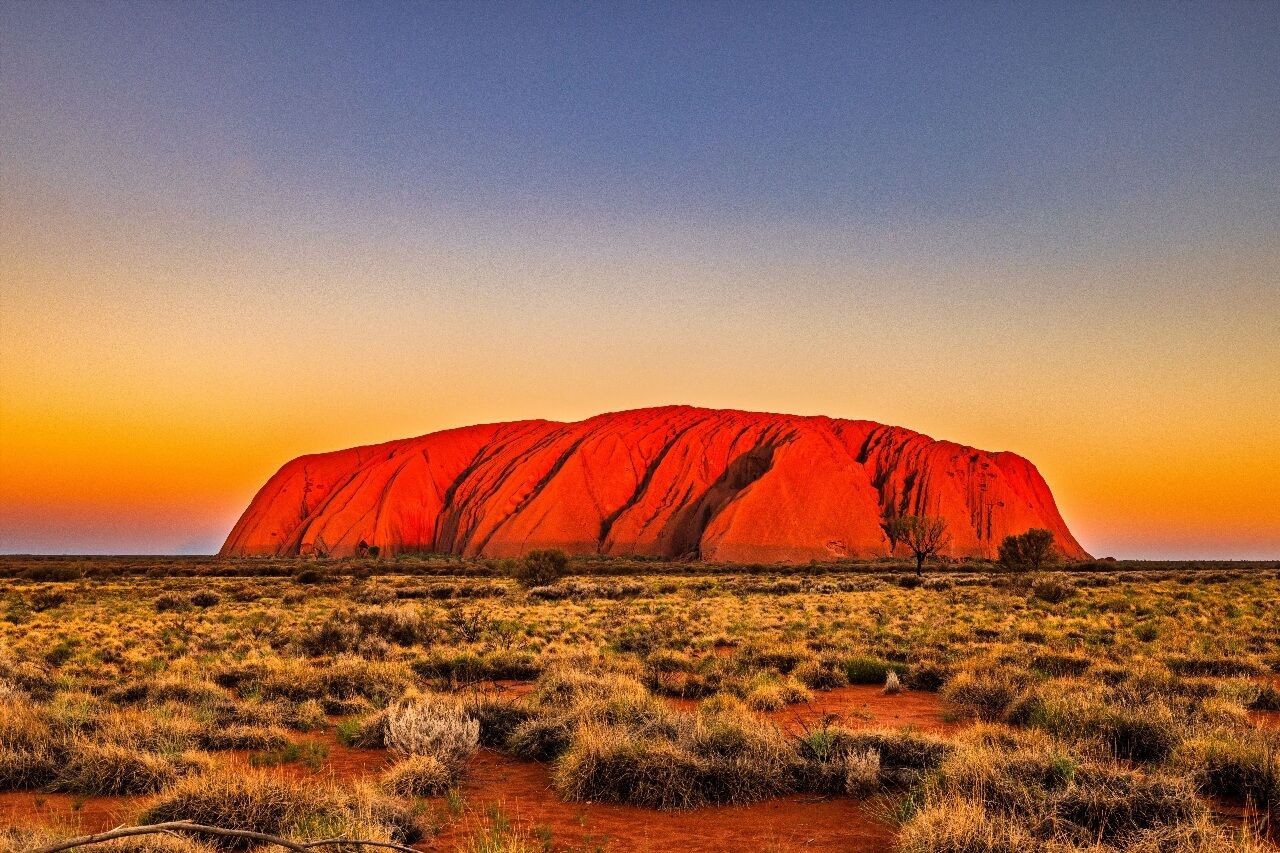
6. Australia, 7,692,024 km²
Australia totals 7,692,024 km² and alone represents an entire continent. It is the sixth largest country and the only one to constitute just one sovereign state on a continental landmass, it has no land border with any other country. This status gives it unique geographical and ecological independence: its isolation has allowed the development of unparalleled endemic fauna.
With only 26.5 million inhabitants, Australian density is 3.4 inhabitants/km². More than 80% of Australians live in major coastal agglomerations: Sydney, Melbourne, Brisbane, Perth, Adelaide. The interior, the Outback, is almost empty of inhabitants: it is estimated that 35% of the continent receives less than 250 mm of annual precipitation, less than the desertification threshold.
The Outback is structured by several great deserts. The Great Victoria Desert (424,400 km²) and the Great Sandy Desert (284,993 km²) are the most extensive. The Great Australian Bight presents coastal cliffs that plunge directly into the Indian Ocean without river mouths for hundreds of kilometers, an unparalleled worldwide coastline. At the center, Uluru (Ayers Rock) is a red sandstone inselberg 348 meters high, 600 million years old, snow-covered year-round, considered sacred by the Anangu people.
On its northeastern coast, Australia has the Great Barrier Reef, the world's largest living organism with 2,300 km in length, visible from space. This structure houses 1,500 fish species, 4,000 mollusk species and is one of only two biological organisms visible to the naked eye from Earth orbit.
The Dimensional Gap: After Australia
Australia marks a clear break in this ranking of countries by area. The first six countries all exceed 7.6 million km². From seventh place onwards, no country exceeds 3.5 million km². India, seventh, is about 40% of Australia. This dimensional jump is often ignored in presentations of country rankings by area, it deserves to be visualized: between sixth and seventh place, area is divided by more than two.
7. India, 3,287,263 km²
India covers 3,287,263 km² and ranks seventh worldwide. It is the world's most populous country since 2023: with 1.44 billion inhabitants in 2025, its national density reaches 438 inhabitants/km², 128 times that of Australia, for an area two and a half times smaller. These figures give a concrete idea of what density means in northern India's plains.
Indian territory presents three major geographical zones. In the north, the Himalaya massif, with peaks exceeding 8,000 meters at the borders of Nepal and China, constitutes the world's highest mountain barrier and influences the monsoons that condition agriculture for the entire subcontinent. The central Indo-Gangetic Plain, traversed by the Ganges (2,525 km), produces more than 40% of national agricultural production on alluvial soil among the world's most fertile. In the south, the Deccan is an ancient basalt plateau, drier, cut by the Krishna and Godavari rivers.
Two often ignored facts. The Thar Desert in the west, straddling India and Pakistan, is the world's third most populated subtropical desert with more than 80 million inhabitants in its extended zone. And if we integrate India's maritime exclusive economic zone (2.37 million km²), India's effective control territory almost doubles, thanks to its 7,500 km of coastline and the Laccadive and Andaman and Nicobar archipelagos.
8. Argentina, 2,780,400 km²
Argentina extends over 2,780,400 km², eighth country in the world and second in South America. Its elongated north-south form, more than 3,700 km of latitude, gives it exceptional climatic diversity among the nations in this ranking. From the subtropical Gran Chaco in the north, with its dense forests and scorching temperatures, to the glaciers of Patagonia in the south, passing through Mendoza vineyards and cereal pampas, Argentina crosses more than six distinct climate zones.
The population exceeds 45 million inhabitants for a density of 16 inhabitants/km². Patagonia in the south alone represents more than one million km², but houses only 2 million people, a density below 2 inhabitants/km². This region is structured by westerly winds among the world's most violent (the "Roaring Forties") and by the Southern Patagonian Ice Field, the planet's third largest glacial reservoir after Antarctica and Greenland, with glaciers retreating at worrying rates.
Argentina also claims a portion of the Antarctic continent and the Falkland Islands. If these territories were integrated into the official area, the country would exceed 3 million km² and rise in the world ranking. These claims remain legally unrecognized internationally.
9. Kazakhstan, 2,724,900 km²
Kazakhstan (Astana, Kazakhstan) covers 2,724,900 km² and constitutes the largest country in Central Asia, as well as the world's largest state without ocean access. Landlocked between Russia, China, Kyrgyzstan, Uzbekistan and Turkmenistan, it occupies a key position on the former Silk Roads. Its area is larger than that of all of Western Europe (France + Spain + Germany + Italy + Iberian Peninsula).
With only 19.5 million inhabitants, Kazakhstani density is 7.2 inhabitants/km². The territory is dominated by steppe in the west and north, one of the world's largest temperate grasslands, and by arid deserts in the center and south. The Aral Sea catastrophe, once the world's fourth largest inland sea, illustrates the risks linked to exploiting these spaces: it has lost more than 90% of its surface in 60 years due to Soviet irrigation diversions, leaving behind toxic salt plains.
In the east, the Tian Shan mountains exceed 7,000 meters at the Kyrgyz border (Jengish Chokusu peak, 7,439 m). The Baikonur cosmodrome, in the country's south, is the world's oldest and largest space launch site, leased to Russia since Kazakhstani independence in 1991. It is from there that Yuri Gagarin took off in 1961.
10. Algeria, 2,381,741 km²
Algeria (Algiers, Algeria) is Africa's largest country since 2011, with 2,381,741 km², tenth worldwide rank. This rank often surprises Europeans, for whom Algeria is primarily a Mediterranean country. Reality: Algeria is four times larger than France and its territory encompasses the largest portion of the Sahara among all Saharan countries. The Mediterranean coastal fringe and the Tell high plateaus, less than 12% of the territory, yet concentrate more than 90% of the 46 million Algerians.
The rest is Sahara. At the country's heart, the volcanic Hoggar massif peaks at 3,003 meters (Tahat summit) and constitutes one of the world's most spectacular desert landscapes, with its granite rock forests sculpted by millions of years of wind erosion. Temperature can exceed 45°C during the day and drop below 0°C the same winter night, a daily thermal amplitude of 50 degrees that illustrates Saharan extremes.
Algeria regained the title of Africa's largest country after Sudan's partition in 2011. Before this date, Sudan occupied the first continental place with about 2.5 million km².
11. Democratic Republic of the Congo, 2,344,858 km²
The Democratic Republic of the Congo (Kinshasa, DR Congo) (DR Congo) covers 2,344,858 km², eleventh worldwide rank and second African country. The territory is structured around the Congo Basin, the world's second largest hydrographic basin with 3.7 million km² of drainage. The Congo River is the world's deepest, with sections reaching 220 meters deep, and its flow is second after the Amazon.
The Congolese tropical forest, which covers about 155 million hectares, is the second largest equatorial forest massif after the Amazon. It stores carbon amounts comparable to the Amazon forest and houses rare endemic species: bonobo, okapi, Grauer's gorilla. With 100 million inhabitants approximately, the national density is 43 inhabitants/km², but distribution is very unequal between the quasi-uninhabited central basin and the eastern volcanic regions.
A little-known fact: the DR Congo has an Atlantic coastal fringe of only 37 km, one of the shortest maritime openings of a large country. All maritime trade transits through this bottleneck around the city of Moanda. If the DR Congo were a landlocked country, its access to global markets would be radically affected.
12. Saudi Arabia, 2,149,690 km²
Saudi Arabia (Riyadh, Saudi Arabia) occupies 2,149,690 km² on the Arabian Peninsula, twelfth worldwide rank. Almost all of the territory is desert: the Rub' al Khali (Empty Quarter) in the south constitutes the world's largest continuous sand desert with 650,000 km². No permanent road crosses it. Summer temperatures there regularly exceed 55°C at ground level, and dunes can reach 250 meters in height.
With 36 million inhabitants and a density of 17 inhabitants/km², the population concentrates in the cities of Riyadh, Jeddah and Mecca. The country has no permanent rivers: all freshwater resources come from fossil aquifers, whose current pumping rate far exceeds natural recharge. The highest point is Jabal Sawda (3,015 m) in the Asir massif in the southwest, a region that receives summer monsoon precipitation, a striking contrast with the rest of the country.
Saudi Arabia illustrates an extreme case in this ranking: an immense territory of which less than 5% is considered easily habitable or cultivable.
13. Mexico, 1,964,375 km²
Mexico extends over 1,964,375 km², thirteenth worldwide rank and third country of the Americas. This area is regularly underestimated: Mexico is almost four times larger than France and represents more than 40% of Central and North America excluding the United States and Canada. With 130 million inhabitants and a density of 66 inhabitants/km², it is the eleventh most populated country in the world.
The territory is dominated by the Mexican Plateau (Altiplano), which extends above 2,000 meters altitude between two parallel mountain chains: the Sierra Madre Occidental and the Sierra Madre Oriental. Mexico City, the capital, is built at 2,240 meters altitude on the former Lake Texcoco bed, a city of 22 million people on lacustrine sediment soil, which explains its recurring problems of subsidence and amplified earthquakes. Popocatépetl (5,426 m), one of the planet's most active volcanoes, is visible from the capital on clear days.
Mexico also has one of the longest maritime facades in the ranking, with 11,122 km of coastline between the Pacific, Gulf of Mexico and Caribbean Sea.
14. Indonesia, 1,904,569 km²
Indonesia (Jakarta, Indonesia) covers 1,904,569 km² in total land area, but its real dimension is that of an archipelago: 17,508 islands, of which about 6,000 are inhabited, spread over an east-west distance equivalent to crossing Europe from Lisbon to Moscow. It is the world's largest archipelago and the only nation in this ranking without a single continental territory.
With 277 million inhabitants, Indonesia is the world's fourth most populated country. The national density of 146 inhabitants/km² hides extreme contrasts: Java (132,000 km²) alone houses 157 million people, a density of 1,189 inhabitants/km², when Kalimantan (the Indonesian part of Borneo, 539,000 km²) has only 16 million. Indonesia has 127 active volcanoes, making it one of the countries most exposed to volcanic risk on the planet.
If we added territorial waters and the exclusive economic zone to land area, Indonesia would surge in this ranking: its EEZ covers nearly 6.2 million km², a maritime territory three times larger than its emerged lands.
15. Sudan, 1,886,068 km²
Sudan (Khartoum, Sudan) totals 1,886,068 km² since the 2011 partition that gave birth to South Sudan, ceding the southern oil provinces and lowering its area by about 600,000 km². Its territory covers the junction between the Sahara in the north and the Sudanese savanna in the south, crossed by the Nile which confluences at Khartoum by reuniting the Blue Nile (coming from Ethiopia) and the White Nile (coming from equatorial Africa).
The confluence of the two Niles at Khartoum is one of the world's most visual hydrological phenomena: the muddy, sediment-laden waters of the Blue Nile flow side by side with the clearer waters of the White Nile for several kilometers before merging into a single artery. National density reaches about 23 inhabitants/km² for a population of about 46 million inhabitants, mostly rural.
16. Libya, 1,759,541 km²
Libya (Tripoli, Libya) extends over 1,759,541 km², sixteenth worldwide rank and third African country by size. 90% of the territory is desert. The Fezzan, in the southwest, is one of the most inhospitable regions of the Sahara, with daily thermal amplitudes that can exceed 40°C and summers where the thermometer does not drop below 35°C at night.
The population of about 7.5 million inhabitants is grouped almost exclusively on the Mediterranean coastal strip, which represents less than 10% of the territory. National density is 4 inhabitants/km², but effective coastal density is several dozen inhabitants per km². Libya illustrates an extreme case: immense territory for a population equivalent to that of a large metropolis like inner Paris. The subsoil conceals oil reserves among Africa's most important and the Nubian aquifer system, one of the world's largest fossil aquifers, shared with Egypt, Chad and Sudan.
17. Iran, 1,648,195 km²
Iran covers 1,648,195 km², seventeenth worldwide rank. The territory is structured around a large arid central plateau framed by mountain chains. The Dasht-e Kavir and Dasht-e Lut are among the world's hottest deserts: the Dasht-e Lut recorded a surface temperature of 70.7°C in 2005, measured by NASA satellite, the highest land surface temperature ever documented.
The Alborz peaks at 5,610 meters at Damavand, the Middle East's highest peak, snow-covered year-round. With 87 million inhabitants and a density of 53 inhabitants/km², the population concentrates in a northwest/northeast arc between Tabriz, Tehran and Mashhad, leaving the center and southeast of the plateau quasi-desert.
Iran is the only country in this ranking to straddle three tectonic plates (Arabian, Eurasian and Indian), which explains its high seismicity. The country undergoes on average one earthquake of magnitude 5 or higher each month.
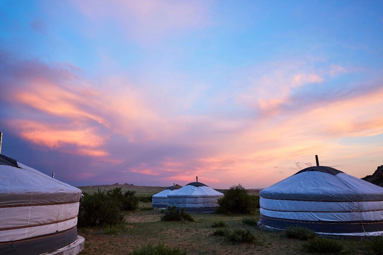
18. Mongolia, 1,564,116 km²
Mongolia (Ulaanbaatar, Mongolia) covers 1,564,116 km² for only 3.4 million inhabitants, a density of 2.1 inhabitants/km², the lowest of any continental sovereign country. The territory is shared between steppe in the north and the Gobi Desert in the south, which covers about 1.3 million km² including the Chinese part. The capital Ulaanbaatar alone concentrates 45% of Mongolians, a demographic imbalance unparalleled in this ranking.
This capital/rest of country ratio is unique in the world: no other nation sees its main city capture such an overwhelming proportion of the population. Outside Ulaanbaatar, Mongolia remains one of the last great spaces of active pastoral nomadism, with about 30% of the population living in yurts (ger in Mongolian) and moving to the rhythm of the seasons.
The Mongolian Gobi is one of the world's coldest deserts in winter: temperatures regularly drop below −30°C in January, while summers can exceed 45°C in bare rock areas. This annual amplitude of more than 75 degrees is among the highest of any inhabited land surface.
19. Peru, 1,285,216 km²
Peru covers 1,285,216 km² and ranks nineteenth worldwide. Its territory juxtaposes three radically distinct geographical zones over less than 700 km from east to west: the arid Pacific coast (one of the world's driest, with certain zones exceeding 20 years without rain), the Andes Cordillera (several peaks exceed 6,000 meters) and the Amazon forest to the east, which constitutes 60% of the territory. With 33 million inhabitants and a density of 26 inhabitants/km², Peru presents massive urbanization around Lima, a metropolis of 11 million inhabitants on the Pacific coast.
Lake Titicaca, at 3,812 meters altitude at the Bolivian border, is the world's highest navigable lake. The Ucayali River, an Amazon tributary born in the Peruvian Andes, travels more than 1,700 km before joining the great river. Peru has one of the world's most productive Pacific EEZs in terms of fishing, thanks to the Humboldt Current.
20. Chad, 1,284,000 km²
Chad (N'Djamena, Chad) closes this expanded ranking with 1,284,000 km², twentieth worldwide rank and fourth African country by area. Its territory crosses three climate zones from north to south: the arid Sahara in the north (Tibesti massif, highest point 3,415 m), the semi-arid Sahelian zone in the center, and the humid Sudanese savanna in the south. Lake Chad, which once gave its name to a vast body of water shared with Niger, Nigeria and Cameroon, has lost 90% of its surface since the 1960s under the effect of drought and agricultural withdrawals.
With 18 million inhabitants and a density of 14 inhabitants/km², Chad presents a very marked north-south distribution: the Saharan north is quasi-uninhabited, while the south concentrates the majority of the population and agricultural activities.
Exclusive Economic Zone and Real Area: What the Tables Don't Say
Land area is the standard criterion of this country ranking by area, but it does not reflect a country's effective control over its territory. The maritime exclusive economic zone (EEZ), which extends to 200 nautical miles (370 km) from coasts, offers the state sovereign rights over all underwater natural and fishing resources. For island countries, this radically changes the equation.
Indonesia (14th in our ranking) has an EEZ of 6.2 million km², larger than its land territory by a factor of three. The United States has the world's largest EEZ (11.3 million km² including territories), thanks to Alaska, Hawaii, Guam and other Pacific islands. France, absent from this ranking in land area (551,000 km²), has the world's second largest EEZ (11.1 million km²) thanks to its overseas territories in the Caribbean, Pacific and Indian Ocean.
The distinction between area with and without inland waters is equally important for continental countries. Canada sees its area vary from 9.09 million km² (strictly emerged lands) to 9.98 million km² (with interior lakes and rivers) depending on the consulted source. The difference of nearly 900,000 km² corresponds almost to Egypt's area. If you compare different tables, always check the convention used before drawing conclusions.
Finally, disputed territories generate variations that even official bodies do not resolve. Kashmir is claimed by India, Pakistan and China. Western Sahara is administered by Morocco but claimed by the Polisario Front. Crimea is counted in Ukrainian or Russian area depending on sources. None of these divergences is resolved in this ranking, which follows UN figures for countries subject to claims.
If this world geography subject makes you want to explore these countries differently, our Ryo app offers audio-guided tours in several major world cities, from Asian megapolises to European historic centers. A concrete way to move from country area, abstract on a map, to the experience of territory traversed at human height.
FAQ
What Is the Largest Country in the World by Area?
Russia occupies the first place in this country area ranking with 17,098,242 km² of total area. It spans 11 time zones, from the Kola Peninsula on the Baltic to the Bering Strait, just a few kilometers from Alaska. Its area represents about 11% of the world's emerged lands and is almost twice that of Canada, the second largest country. Russia is both the largest country in Europe and the largest country in Asia, since it extends over both continents with three-quarters of its territory in Asia.
What Is the Largest Country in Africa?
Since 2011, Algeria is the largest country in Africa with 2,381,741 km². It regained this title after the partition of Sudan, which was previously the first with about 2.5 million km². Algeria precedes the Democratic Republic of Congo (2,344,858 km²), Sudan (1,886,068 km²) and Libya (1,759,541 km²). In fifth African position comes Chad with 1,284,000 km².
Which Countries Have the Largest Area but the Smallest Population Density in This Country Ranking?
Among large countries, Mongolia displays the lowest density: 2.1 inhabitants/km² for 1.56 million km². It is followed closely by Australia (3.4 inhabitants/km²) and Canada (3.9 inhabitants/km²). Libya also drops to 4 inhabitants/km² for 1.76 million km², and Russia to 8.6 inhabitants/km² for 17 million km². These figures illustrate that area and population are not correlated: it is water resources and climatic conditions that determine habitable zones.
What Is the Largest Country Without Access to the Sea?
Kazakhstan is the world's largest landlocked country with 2,724,900 km². It largely precedes Mongolia (1,564,116 km²), Ethiopia (1,104,300 km²) and Niger (1,267,000 km²). Note: Kazakhstan borders the Caspian Sea, but it is a closed salt lake without connection to the oceans. For maritime trade exchanges, Kazakhstan therefore depends on land infrastructure and transit territories.
How Do You Measure the Area of a Country?
In any ranking of countries by area, the official area of a country generally includes emerged lands and inland waters (lakes, internal rivers), but excludes the maritime exclusive economic zone (EEZ). Figures vary slightly depending on sources due to disputed zones, cartographic projection methods and the inclusion or exclusion of inland waters. Reference data comes from national cartographic services and the UN (Statistics Division). The difference can be significant: for the United States, the strict land area is about 9.15 million km² versus 9.83 million with inland waters.
Why Do Common Maps Distort the Size of Countries?
Most maps use the Mercator projection (1569), which preserves shapes but distorts surfaces at high latitudes. In this projection, Greenland seems as large as Africa, while Africa is 14 times larger. Russia appears enormous (which it actually is), but the distortion further amplifies its perceived size. The Peters projection (or equivalent cylindrical projection) restores real surfaces but distorts shapes. Google Maps partially corrected this bias in 2018 by adopting a Globe projection rather than Mercator at small zoom scales.
Which Country Has the Largest Exclusive Economic Zone?
The world's largest EEZ belongs to the United States with about 11.3 million km², thanks to their numerous island territories in the Pacific and Caribbean. They are followed by France (11.1 million km²), the world's second EEZ despite a modest metropolitan land area, thanks to French Polynesia, Guyana, New Caledonia and other overseas territories. Australia (8.1 million km²) and Russia (7.6 million km²) complete the world's top 4 EEZs.
Conclusion
The 20 countries in this country area ranking together cover more than 91 million km², about 61% of emerged lands on the planet. Their collective demographic weight nonetheless remains below 50% of the world population: area and population do not coincide. Russia alone is worth 17 times France. Australia is an entire continent for 26 million inhabitants. Mongolia, so discreet on printed maps, exceeds the cumulative area of France, Germany, Spain, Italy and Benelux.
This country area ranking is above all a corrective to the cartographic projections we all learned at school. Greenland is not larger than Africa. Algeria is much larger than Alaska. And Kazakhstan, which many vaguely place between Russia and China, is larger than all of Western Europe. If these geographical realities make you want to see these territories up close, Ryo offers audio-guided tours in several major cities of these countries, a way to start inhabiting them, at least for the space of a walk.