© Shutterstock
 Votre guide Ryo
The Cité d'Aleth in Saint-Malo: History, Blockhaus and Walks on the Peninsula (2026)
Saint-Malo immediately evokes its ramparts and corsairs, but the true origin of the city lies a few hundred meters south, on a granite tongue battered by the Rance. The Saint-Servan peninsula houses the Cité d'Aleth, a stratified archaeological site representing two thousand years of human occupation: Gallo-Roman city, medieval episcopal seat, Vauban fortress, then Wehrmacht bunker. Today transformed into a freely accessible public park, this ancient city offers some of the most striking panoramas of the entire Emerald Coast, and yet, most visitors pass by without stopping.
Here, you will walk on the foundations of ancient Reginca, enter a German blockhaus preserved with its original equipment, observe the remains of the Romanesque Saint-Pierre cathedral from the cliff, and understand why the bishops of Aleth chose this rock even before Saint-Malo existed. This guide accompanies you to every point of the site, with updated schedules and a walking itinerary of less than three hours to miss nothing. If you're planning a full day in the area, the Ryo audio guide tour of Saint-Malo perfectly complements this exploration with the intra-muros districts, the castle and Grand Bé.
Cité d'Aleth, Cradle of Saint-Malo: 2000 Years of History Summarized
To understand Saint-Malo, you must first understand that it wasn't there at the beginning. The fortified city that tourists photograph today from the Sillon is only a late medieval creation. The real metropolis, the one that structured this territory since Antiquity, stood on the Saint-Servan peninsula, at the mouth of the Rance.
Reginca, the Gallo-Roman name of the site, designated in the 1st century an agglomeration equipped with thermal baths, a forum and an urban enclosure. Archaeological excavations conducted since the 1970s have uncovered traces of roads, floors in brick concrete and fragments of sigillata ceramics characteristic of a second-tier but well-structured Romanized city. The position was strategic: the peninsula controls the outlet of the Rance into the sea, monitors the entrances to the natural harbor and constitutes a natural defensive stronghold surrounded by water on three sides.
In the 9th century, Aleth was promoted to the rank of bishopric. This early Christianization of Breton territory is linked according to tradition to Saint Aaron, a Welsh hermit established on the neighboring rocky island, the one that Malouins would later call Aaron Island, then Saint-Malo Island, then simply "the City". The relationship between Aleth and this island is constitutive of all regional history: the bishopric remained several centuries on the peninsula before crossing the channel and settling definitively on the fortified island in the middle of the 12th century. It is this episcopal move that symbolically founded Saint-Malo and condemned Aleth to become a periphery of its own heir.
The medieval site preserves important vestiges from this period. The Late Empire castrum enclosure was reused as a base for successive fortifications. Merovingian sarcophagi have been unearthed on the north flank. The Saint-Pierre cathedral, of which only consolidated ruins remain, testifies to the cultic importance of the place until at least the 12th century.
Vauban visited the site in 1693 and recommended fortification works. The peninsula received a new bastioned enclosure during the 18th century, whose layouts are still partially readable in the topography of the current park. Then came the Revolution, the dismantling of ecclesiastical institutions, and a long period of relative oblivion until World War II brutally reactivated the military value of the site.
Organization Todt transformed the peninsula into a defensive strongpoint between 1941 and 1944. Coastal artillery batteries were installed on the high points, a command blockhaus was dug into the rock, casemates covered maritime approaches. In August 1944, during the liberation of Saint-Malo, the site was the theater of violent combat. The toll was heavy: several historic buildings destroyed, shell craters still visible in certain areas of the park.
Saint-Pierre d'Aleth Cathedral
At the summit of the peninsula, a few sections of gray granite wall rise against the sky. These consolidated ruins are all that remains of the Saint-Pierre d'Aleth cathedral, an edifice founded according to tradition in the 6th century and rebuilt several times until the 12th century. They nevertheless constitute one of the most moving testimonies of the site.
The cathedral's history is inseparable from the episcopal move. When Bishop Jean de Châtillon transferred his seat to the neighboring island between 1144 and 1146, he did not destroy the Alethian edifice, he simply abandoned it, letting it deteriorate for several centuries. A parish community maintained the place in use until at least the 17th century, when the buildings were definitively decommissioned. The Revolution delivered the final blow: the cut stones were pillaged for civil constructions, a common practice throughout revolutionary France.
What remains today is unspectacular at first glance but very instructive for those who take time to read the landscape. The preserved walls, two to four meters high, let one guess the Latin cross plan of the late Romanesque edifice. Interpretation panels installed by the city of Saint-Malo explain the different construction phases identified by archaeologists. Excavations from the 1980s-1990s notably uncovered burials under the nave floor, conforming to medieval funerary practices of "ad sanctos" inhumation.
The position of the ruins is remarkable in itself. From this location, one simultaneously dominates the Saint-Malo harbor to the north, the Rance estuary to the east and Saint-Cast bay to the southwest. Cathedral builders had an eye for panoramic sites, and the bishops of Aleth were no exception.
Allow 15 to 20 minutes for an attentive visit of the ruins with reading of the panels. Access is free and without time constraints. In clear weather, the place is particularly photogenic in late afternoon, when the low light brings out the stone joints and different masonry phases.
Solidor Tower: Sentinel of the Centuries
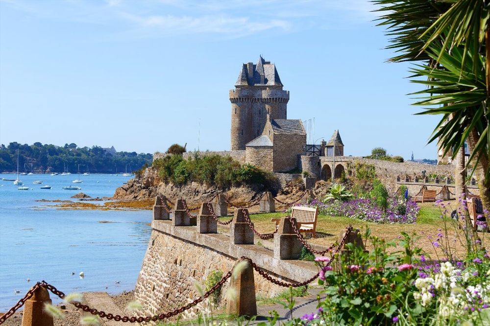
At the southern tip of the peninsula, on the banks of the Rance, the Solidor tower (Quai Solidor, 35400 Saint-Malo, rated 4.3/5 on Google for 7 reviews) is one of the best-preserved medieval monuments on the entire Breton coast. Its three connected towers, an uncommon architectural device, form a silhouette recognizable from afar, especially from the ferry that goes up the Rance toward Dinard.
Built between 1369 and 1382 on orders from Duke of Brittany Jean IV, the tower had a precise function: control the Rance estuary and collect passage rights on boats going up to Dinan, at a time when the city of Saint-Malo did not recognize ducal authority. It was above all a fiscal tool as much as a fortress. The three connected towers system allowed crossing fire on the estuary from several angles, while offering sufficient living space for a permanent garrison. The local granite masonry, assembled without mortar in some places, reaches thicknesses of two meters in places.
The tower today houses the International Museum of Cape Horn Long-Course Sailing, entirely devoted to navigators who rounded Cape Horn. This thematic specialty may surprise, but it's geographically explained: Saint-Malo was throughout the 19th century one of the great outfitting ports for voyages to South America and the Pacific. Malouin sailors who left for these expeditions of six to eighteen months often embarked from the Saint-Servan quays, under Solidor's gaze.
The museum presents navigation instruments, logbooks, Cape Horn sailing ship models, objects brought back from the South Seas and captain portraits. The climb to the tower tops rewards the effort with a 360° panorama over the harbor, intra-muros ramparts and countryside behind Dinard. Full price: €6 for adults, free for under-18s. The museum is open year-round, with broader hours from April to September (generally 10am-12:30pm and 2pm-6pm) and reduced hours in low season, closed Mondays except high season; check precise hours with the Saint-Malo tourist office.
The building itself deserves particular attention independent of the museum content. The lower room, covered by a granite barrel vault, creates a particular acoustics. The window seats allow measuring the wall thickness. The spiral staircases carved from solid rock are remarkably precise for 14th-century masonry.
The Blockhaus, 39-45 Memorial: Under World War II
Cité d'Aleth (Presqu'île de Saint-Servan, 35400 Saint-Malo, rated 4.6/5 on Google for 179 reviews) preserves one of the best-documented blockhaus on the entire Channel coast, converted into a 39-45 memorial by the city of Saint-Malo, and its interest far exceeds military voyeurism. The German command blockhaus, dug into the rock under the medieval ruins, served as operational HQ during the Saint-Malo siege of August 1944. It was here that Colonel Andreas von Aulock, nicknamed "the Madman of Saint-Malo" by the American press, organized the resistance of the Aleth fort garrison, surrounded on August 9th, which only capitulated on August 17, 1944 after more than a week of bombardment and two particularly deadly infantry assaults.
The guided visit begins with an introduction room that recontextualizes the German occupation of Saint-Malo: Organization Todt arrived in 1941, requisitioned inhabitants from strategic zones, and transformed the peninsula into a strongpoint of the "Atlantic Wall". Work lasted three years. Coastal artillery batteries were installed on high points, connected by a network of underground galleries carved into rock. The Aleth peninsula became a fortress within the fortress.
Inside, the rooms are preserved in their 1944 state, equipment included. You'll see communication desks, wall maps, camp beds in officers' dormitories, manual ventilation ducts and equipment reserves. The memorial today assembles more than 1,500 objects. Artificial lighting maintained at low intensity reinforces the austere atmosphere. Some graffiti left by German soldiers are still readable on the concrete walls.
The visit also addresses the siege itself: American bombardments that devastated 80% of the intra-muros old town between August 6 and 17, 1944, civilians taking refuge in cellars, desperate negotiations. One room is devoted to evacuated inhabitants, destruction and laborious reconstruction of the 1950s. It's one of the rare museum spaces in the region to frontally treat the war from the local civilian perspective, not just from the military angle.
Price: about €7 for adults, €3.50 for students and schoolchildren, and family rate around €18 (2 adults + 2 to 4 children). The guided visit alone lasts about 1 hour; a formula with multimedia projection extends duration to about 1h45. Booking recommended in July-August, as groups are limited to 25 people maximum for safety reasons in underground galleries. Visits take place at cool and constant temperature, bring an extra layer even in summer. Access forbidden to people with reduced mobility for the underground part. Check prices and time slots for the current season with the Saint-Malo tourist office, as they evolve from year to year.
Cité d'Aleth Park: Panoramas and Walks
Beyond the monuments, Cité d'Aleth is above all a public park of 15 hectares open year-round, freely accessible and maintained by the city of Saint-Malo. It's one of the best-positioned green spaces on the entire northern Breton coast: the peninsula extends into the sea like a prow, and from its flanks, the view simultaneously embraces the Saint-Malo harbor, the open sea toward Jersey, the Rance estuary and the heights of Dinard.
The park's vegetation mixes lawns blown by sea wind, groves of sea buckthorn and marram grass, pink geranium slopes and some areas of bare moor on the most exposed points. Paths are marked but not uniformly paved, prefer closed shoes if you come after a rainy period. Part of the rampart paths follow rocky precipices without guardrails: watch children.
Two viewpoints deserve particular attention. The first, northwest, faces the intra-muros ramparts and Grand Bé island at high tide. In clear weather, you can distinguish with the naked eye the Chausey islands and, in the opposite direction, the Dinard coast up to Cap Fréhel. The second, south, overlooks the Rance and its tidal power station: an industrial and poetic view at once, especially at dusk when the channel's light beacons progressively light up.
The park is also a recognized spot for ornithological observation. The cliffs shelter colonies of crested cormorants and gannets during spring migration. Herring gulls nest on some inaccessible rocky outcrops. In winter, shorebirds frequent the groves exposed at low tide. For amateur ornithologists, the hour following sunrise in March-April offers the best observation chances.
There is no café or refreshment stand in the park itself, bring your own drinks, especially in summer. Picnic tables are installed on several lawns sheltered from the prevailing wind. Park entrance is free, without time stamping or purchase obligation.
The Rampart Path and Panoramas over the Rance
The rampart path that circles the Aleth peninsula is probably the most beautiful coastal trail in the Malouin region. Accessible on foot from the Saint-Servan center in less than ten minutes, it follows the pink granite cliffs for about 2.5 kilometers of perimeter and offers a succession of changing perspectives according to hour and season.
The eastern part of the path follows the Rance estuary in its last kilometers before the sea. At rising tide, the current is visible to the naked eye, the Rance flow can reach 18,000 m³ per second during great spring tides, a figure that explains why the tidal power station built in 1966 remains today still one of the largest installations of this type in the world. The bridge-dam is visible from several points on the path, and its locks regularly open to let sailboats going down to sea pass, a fascinating mechanical spectacle to observe from the heights.
The western part of the path faces the open sea and is more exposed to wind. At high tide coefficient (above 90), the rocks at the cliff base are exposed for several hundred meters, revealing an intertidal zone very rich in marine species: anemones, starfish, crustaceans, kelp algae. Shore fishermen come here regularly, equipped with their nets and buckets. The practice is tolerated but regulated: respect shore fishing quotas and put rocks back in place after turning them over.
The path topography varies: some short climbs on rocky promontories, long flat sections on consolidated terraces, some narrow passages between two slopes. The complete loop takes 45 to 60 minutes for an ordinary walker, longer if you stop at the different viewpoints.
Gallo-Roman Traces: Enclosure, Baths, Forum
The Gallo-Roman city of Reginca is largely invisible to the naked eye, but the trained eye begins to grasp its contours once you know where to look. The archaeological excavations conducted since the 1970s, first under Loïc Langouët's direction then in collaboration with the Brittany Regional Archaeological Service, have produced considerable documentation on the ancient agglomeration.
The Late Empire enclosure, dated to the 4th century, is the most visible vestige. Sections of wall in small schist and granite apparatus sporadically reappear in the park's topography, sometimes integrated into later medieval or modern structures. The construction technique, courses of stones bound with lime mortar, at regular intervals reinforced by rows of flat bricks, is characteristic of late fortification in western Gaul.
Public baths have been located northeast of the peninsula, in immediate proximity to the shore. Soundings have identified lead pipes, hypocausts (underfloor heating systems characteristic of Roman thermal establishments) and painted plaster fragments. Their area is estimated at about 800 m², corresponding to a medium-sized establishment for a secondary agglomeration. They are not directly accessible to the public, but several in-situ panels on the route indicate their location.
The forum is hypothetically placed at the peninsula's central flat area, where slopes are least steep. Soundings from the 1990s revealed traces of paving and a large apparatus wall that could correspond to a commercial portico. Research continues: Cité d'Aleth figures among major archaeological sites for knowledge of western ancient agglomerations.
To deepen this subject, the Saint-Malo history museum, located in the intra-muros castle, preserves part of the archaeological material from Aleth excavations: ceramics, coins, metal objects and funerary steles. From there, the walled city unfolds over 30 commented stops.
Guided Walk: How to Cover the Peninsula Step by Step
Cité d'Aleth is not vast, about 2 km north to south by 400 meters wide at its widest point, but it's rich in details superimposed over two millennia. A truly complete visit, which doesn't skim over the panels, easily takes 2h30 to 3h. Here's a logical itinerary to optimize discovery.
Recommended starting point: Solidor tower parking (free, accessible from Saint-Servan center via rue Dauphine then quai Solidor). Begin with Solidor tower as soon as the museum opens, before group arrivals. Morning coolness and low light on the Rance give the building its best photographic aspect.
From Solidor, climb north via the eastern rampart path. The ascent is gradual, views over the estuary open quickly. After about ten minutes, you reach the sector of Saint-Pierre cathedral ruins. Take time to read the panels and identify different masonry types: Carolingian schist, Roman granite, medieval rubble.
Continue north to the main viewpoint, which overlooks the Saint-Malo harbor and ramparts. It's one of the best places to understand the geographical relationship between Aleth and the fortified island: 300 meters of channel, an arm of sea crossable at low tide until the Middle Ages, which nevertheless separated two distinct worlds. You can perfectly see, from this point, how Saint-Malo island gradually densified at Aleth's expense.
Then descend via the park's western face to the blockhaus. The 39-45 memorial guided visit lasts about an hour; check the next session time before continuing your tour to avoid waiting. If you have time, the western face of the rampart path, most exposed to the open sea, deserves exploration at low tide to observe exposed rocks.
Loop back to Solidor parking to retrieve your vehicle or take the return path to Saint-Servan on foot in 15 minutes. Total loop distance: about 3.5 km with round trips to monuments. Modest cumulative elevation (about 60 meters), practicable by any able walker, less suitable for strollers.
To go further in discovering Saint-Malo, the Ryo audio guide of Saint-Malo offers an immersive exploration of the intra-muros ramparts, castle and historic districts with geolocated audio commentary available on your smartphone, no wifi needed.
Access, Hours and Practical Information
By car from Saint-Malo center (intra-muros): follow Saint-Servan direction, then "Cité d'Aleth" or "Tour Solidor" signs. Distance: 3 km, about 8 minutes outside summer traffic jams. Free parking at quai Solidor and several adjacent Saint-Servan streets.
By public transport: C2 line of Kéolis Saint-Malo buses serves the "Solidor" stop from the SNCF station and Saint-Malo city center. Variable frequency according to season, consult the Kéolis Saint-Malo website for updated schedules.
On foot from intra-muros: exit via Porte Saint-Vincent, follow quays south to Saint-Servan, then climb to the peninsula. Allow 25 to 35 minutes for an ordinary walker.
Monument hours:
- Cité d'Aleth park: free access year-round, without opening or closing hours.
- Blockhaus/39-45 memorial: open April to October (annual closure from November 1st), guided visits only, closed Mondays in pre and post-season. Hours to confirm with Saint-Malo tourist office.
- Solidor tower/Long-Course museum: open year-round, maximum hours April to September. €6 rate.
No restaurants on site. The nearest shops are in Saint-Servan center, 10 minutes walk.
Where to Eat in Saint-Servan and Around Cité d'Aleth
Saint-Servan has preserved an authentic village character that mass tourism has not yet totally absorbed. Place Bouvet (Place Bouvet, 35400 Saint-Malo, rated 4.2/5 on Google for 180 reviews) and adjacent streets concentrate several decent addresses without reaching intra-muros prices.
For a terrace meal with Rance view, the quai Solidor sector offers some fish and seafood restaurants whose quality varies by season. Establishments operating year-round are generally more reliable than those opening only in July-August. Favor weekday lunch menus: tourist pressure is lower, prices more reasonable, and products often fresher.
For a quick snack before or after the visit, the Saint-Servan center bakery offers sandwiches and pastries. The park's picnic tables are a pleasant alternative if you've prepared your meal, the view from the lawns amply compensates for the lack of service.
If you wish to dine in Saint-Malo after your Aleth day, intra-muros restaurants around Grande Porte and rue Jacques Cartier offer wider choice, but high season queues can be long. Systematically reserve in July-August, even for middle-category addresses.
Last tip: the Saint-Servan market, Friday morning at place Bouvet, is one of the lively markets on the Malouin coast. If your visit falls on Friday, arrive before 9:30am to enjoy local producer crowds before the morning tourist peak.
Cité d'Aleth with Children
The peninsula is generally well-suited for families with children from 6-7 years old. The main attraction for younger ones is undoubtedly the blockhaus: the underground atmosphere, original military equipment and siege history generally captivate children curious about history. Warn them in advance of cool temperature and partial darkness, some sensitive children may be intimidated.
The park itself offers much freedom of movement, with lawns for running and accessible rocks to climb carefully on secured areas. At low tide, exploring the intertidal zone from accessible cliff bases is excellent natural discovery terrain, crabs, shells, algae, small fish in pools. Provide boots or shoes the child can get wet.
Solidor tower may be less captivating for very young ones (Cape Horn museum content assumes autonomous reading level), but climbing to the top remains attractive for the view. The rampart path is practicable with good walking children, but inadvisable with strollers on some narrow sections.

FAQ
What are the opening hours of the Cité d'Aleth blockhaus?
The blockhaus, converted into a 39-45 memorial, is open from April to October, with an annual closure from November 1st, and can only be visited on guided tours. Hours vary by season: in July-August, several daily slots are offered (morning and afternoon); in pre and post-season, visits are fewer and the memorial closes on Mondays. Consult the Saint-Malo tourist office or the city website for precise hours for the current season. Booking is recommended in high season as groups are limited to 25 people for safety reasons in underground galleries.
Is Cité d'Aleth free?
Access to the park is completely free, year-round, without restrictive hours. The Saint-Pierre cathedral ruins are also freely accessible within the park grounds. Only two monuments charge admission: the blockhaus/39-45 memorial (about €7 for adults, €3.50 for students and schoolchildren, family rate around €18) and the Long-Course museum in Solidor tower (€6 adults, free for under-18s). The rampart path walk costs nothing.
How to reach Cité d'Aleth from Saint-Malo intra-muros?
From the Saint-Malo ramparts, allow 25 to 35 minutes on foot following the quays south to the Saint-Servan district, then climbing to the peninsula. By car, it's 8 minutes via the main road to Saint-Servan. Kéolis buses (line C2) serve the Solidor stop from the SNCF station and several city center points.
What can you see from Cité d'Aleth?
The peninsula offers exceptional panoramas in all directions: the Saint-Malo intra-muros ramparts and Grand Bé island to the north, the Rance estuary and tidal power station to the east, the Dinard coast and Cap Fréhel to the west, the Chausey islands and sometimes Jersey on clear days to the northwest. It's one of the best natural viewpoints on the entire Emerald Coast.
How much time should you plan to visit Cité d'Aleth?
A complete visit, park, cathedral ruins, rampart path, blockhaus and Solidor tower, takes 3 to 4 hours including travel time between monuments. If you only visit the blockhaus and take a rampart path tour, allow 2 hours. Just visiting the park and ruins in free exploration takes 1 to 1.5 hours. Plan more time in July-August if you've booked a guided blockhaus tour: waiting can extend.
Is Cité d'Aleth accessible to people with reduced mobility?
Access to the park is possible for wheelchairs on main paved paths. The rampart path on cliffs is however impractical by wheelchair. The underground part of the blockhaus is forbidden to people with reduced mobility for structural reasons. The Solidor tower museum is partially accessible: ground floor rooms can be visited, but climbing to the top via spiral stairs is impossible by wheelchair. The city of Saint-Malo offers an adapted accessibility route, inquire at the tourist office.
Conclusion
Cité d'Aleth holds a singular place in the panorama of Breton historic sites. It is neither a reconstructed castle for tourists, nor an artificially staged open-air museum. It's a living site, park, walks, monuments, where two millennia of history can be read in the very topography of the terrain, in the wall joints and in the rusted equipment of the underground blockhaus.
What strikes most, after a day spent walking the peninsula, is the continuity of the site's strategic value. The Romans understood it, the early Middle Ages bishops too, Vauban confirmed it, and the Wehrmacht made it their defensive priority in 1941. Each occupant left an imprint, and these imprints superimpose without completely erasing, that's exactly what makes the site captivating for those who take time to look.
To extend your Saint-Malo exploration, our Ryo app offers you a complete audio-guided tour of the city: from intra-muros ramparts to Alet beaches, passing through the castle, history museum and corsair streets. This audio walking tour is available offline, directly on your smartphone, to accompany your walk at your own pace, including your return from Cité d'Aleth to the historic heart of the Malouin city.
À lire également