Créé par Romane, le 20 juin 2026
Votre guide Ryo
Excursions Around Ajaccio: Complete Guide to Circuits in 2026
© Shutterstock
A tourist circuit around Ajaccio isn't limited to Napoleonic squares and the old port of the imperial city. From the city, the road opens onto wild Corsica, compressed within an 80-kilometer radius: pink porphyry cliffs plunging into turquoise sea, perched villages where the maquis perfumes the air until autumn, gorges carved in granite that the Prunelli crosses with roaring sounds. Starting by exploring the city with the Ryo audio-guided tour of Ajaccio allows you to establish geographical bearings before setting out on excursions.
This guide covers the tourist circuits around Ajaccio that are truly worth the trip: the Parata nature reserve with its Sanguinaires islands bathed in legendary sunset light, the UNESCO-listed Calanques de Piana, the semi-deserted beaches of Porticcio, the high-altitude hinterland of Bastelica, the Prunelli gorges and their emerald green lake. For each destination: distances from Ajaccio, best times, and tips that competitors don't mention.
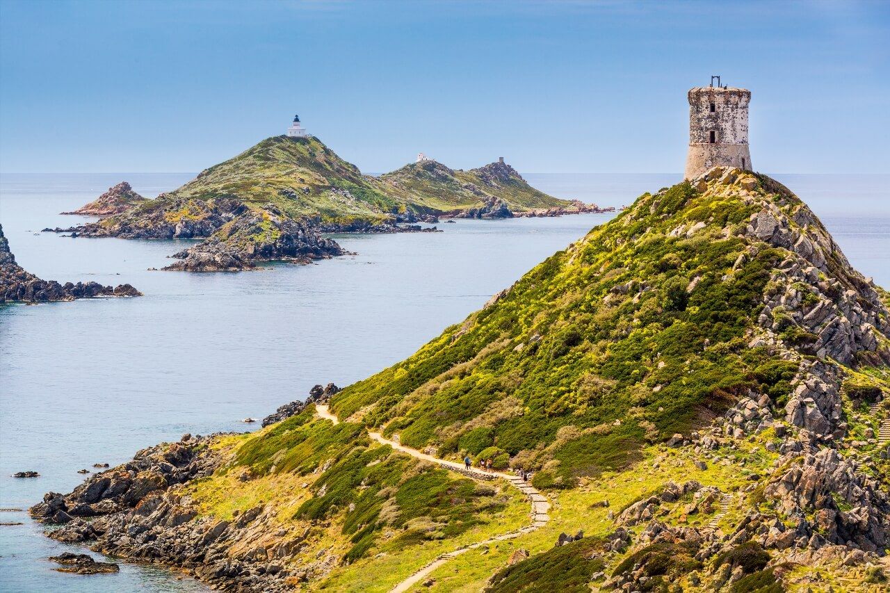
The Parata and Sanguinaires Islands: The Must-See Classic
At 12 km west of Ajaccio at the end of the Sanguinaires road (D111), the Genoese tower of Parata marks the end of a peninsula carved from volcanic rock. The road leading there first follows Saint-Antoine beach, then Minettes beach, before narrowing between two maquis walls. Allow about twenty minutes by car from downtown, or a bit more by bike if you enjoy hills.
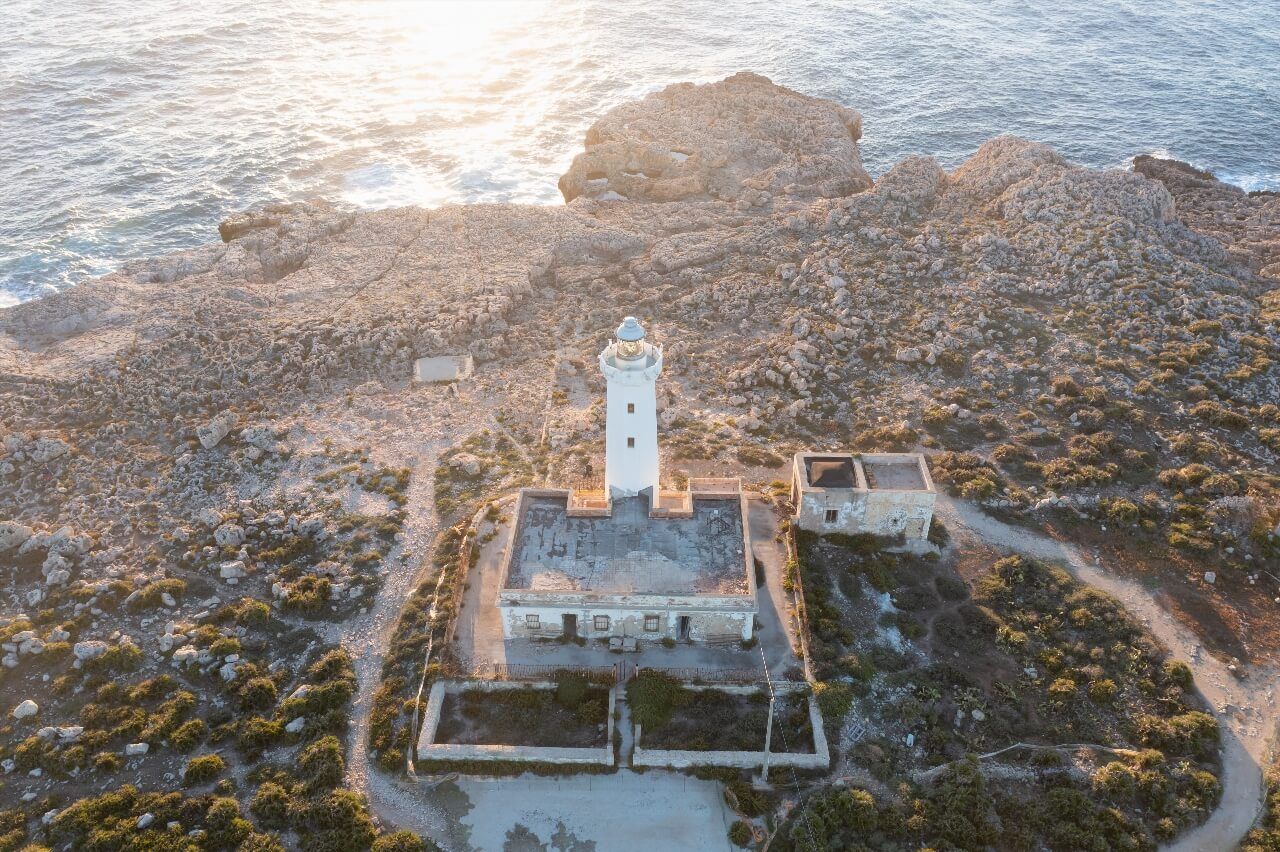
Of the four Sanguinaires islands, only the Grande Sanguinaire is accessible, by boat from Ajaccio port, from May to September. It houses a 19th-century lighthouse, a ruined chapel and some wild sheep. On the continental point, a trail of about 55 minutes circles the peninsula: the panoramas over the archipelago and the gulf of Ajaccio are among the most photographed in all of South Corsica. Local guides aren't mistaken: this is where sunsets take on a unique copper color, accentuated by the red tint of the porphyry rocks.
To avoid crowds, arrive before 9am or after 5pm in July-August. Parking is free but fills up quickly in season. A bus shuttle (line 5) connects central Ajaccio to the Parata every hour in summer, a practical option if you don't rent a car. The Ryo article on visiting the Sanguinaires islands details boat schedules and visiting conditions for the Grande Sanguinaire.
Swimming from the rocks below the tower is excellent, with particularly transparent water even in mid-summer. Bring water shoes: the pebbles are sharp. The bar-restaurant at the parking is decent but expensive, better to bring a picnic and settle on the flat rocks facing the open sea.
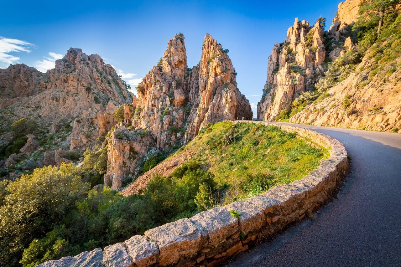
The Calanques de Piana: UNESCO-Listed Corsica
The Calanques de Piana must be earned: 72 km from Ajaccio via the D81, about 1h30 of winding road first following the Gulf of Sagone. But from the first bends above the village of Piana, the reward is immediate. The rose-orange granite columns, sculpted by erosion into recognizable animal shapes (the camel, the horse's head, Napoleon's hat), plunge directly into almost surreal blue sea.
Access is on foot from the Ficajola parking (fee-paying in summer, 5 €) or from the village of Piana (Place de la Mairie, 20115 Piana, rated 4.7/5 on Google for 6 reviews) itself. Two marked trails descend to the coves: the Calanques trail (45 min round trip, easy) and the Caspiu variant (2h, more technical, with hand sections). The coves below are accessible by swimming from the rocks, crystal water, white sand bottom, more reasonable crowds than the beaches of Ajaccio gulf.
The village of Piana is worth the detour in itself: cobbled streets, central fountain, grocery selling Corsican cheese and charcuterie. Arone Beach, 14 km further south via a forest track, is one of the most beautiful beaches in South Corsica, 400 meters of fine sand, turquoise waters, still reasonable crowds outside July-August. Plan a full day to combine Calanques, village and Arone.
Warning: the D81 between Porto and Piana is closed at night in case of fire risk. In July-August, leave before 8am from Ajaccio to avoid traffic jams in Porto. The Ryo article on the must-sees of South Corsica places the Calanques in a broader itinerary if you're planning several days on the island.
A lesser-known alternative: the Route from Cargèse to Piana via the D81 North allows you to combine both destinations in a loop, Ajaccio, Cargèse, Piana, return via the coast. Total distance: 160 km, about 4h driving excluding stops.
Porticcio and the Beaches of Ajaccio Gulf
Porticcio is only 18 km from Ajaccio by road, but also about twenty minutes by maritime shuttle from Ajaccio port, making it the easiest excursion on this list. The Porticcio resort concentrates several fine sand beaches facing the gulf: the Grande Plage (the most crowded), Ruppione Beach (Route de Ruppione, 20166 Porticcio, rated 4.7/5 on Google for 419 reviews) (5 km further south, much quieter) and Agosta Beach (family-friendly, with parking and services).
The maritime shuttle is the best option in summer: it avoids traffic on the coastal road, costs about 8 € round trip, and offers a view of Ajaccio bay that the car doesn't allow. Departures every 30 minutes in July-August from the Citadel quay. Porticcio has a complete water sports offer: paddle, kayak, water skiing, diving. Agosta beach is ideal for families with young children thanks to its shallow waters.
If you have a car, continue to Coti-Chiavari (30 km from Porticcio): this village perched at 600 meters dominates the Gulf of Valinco and North Corsica in a 180-degree panorama. The Chiavari forest, which extends between the two, is one of the rare cork oak forests on the island, accessible via a drivable track from the D55.
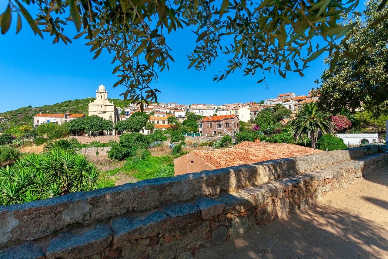
Cargèse, the Greek Village of Corsica
Founded in the 17th century by Greek refugees fleeing Ottoman occupation, Cargèse is one of the most singular cultural curiosities of Corsica. At 50 km north of Ajaccio via the D81, the village is recognizable by its two churches facing each other on the central hill: the Latin Catholic Church and the Greek Church (Byzantine rite), built facing each other as if to symbolize the coexistence of the two communities since the 17th century.
The port of Cargèse, below the village, is modest but charming. Pero beach (2 km north) and Menasina beach (south side) are among the most appreciated on the West coast. Waters are cooler than in Ajaccio, an advantage in mid-August. Several fish restaurants on the port offer menus for less than 25 € at lunch, which is rare in Corsica in high season.
A Corsican products market takes place Sunday morning at the church square, cheeses, charcuterie, maquis honey, prickly pear jams. Arrive before 10am for the best products. A visit to Cargèse naturally combines with the Calanques de Piana (25 km further north) in a well-filled day from Ajaccio.
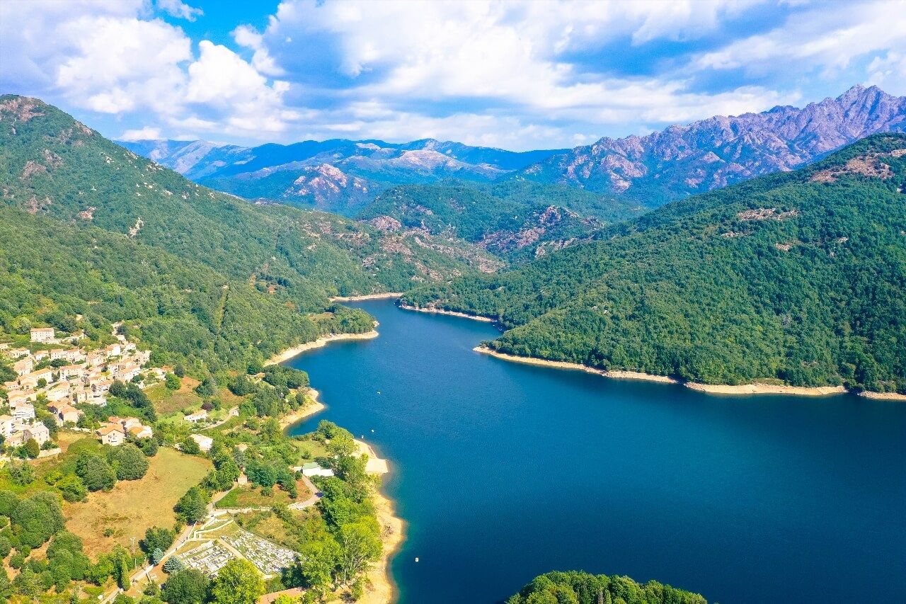
The Prunelli Gorges and Lake Tolla
For those seeking to get away from the coastline, the Prunelli gorges offer spectacular inland Corsica less than an hour from Ajaccio. The road goes up the Prunelli valley from Cauro (25 km), passes through the village of Peri and its medieval streets, then reaches the Tolla dam and its emerald green reservoir lake.
The village of Tolla has been reflected in the lake since 1960, when the dam was flooded. Several hiking trails start from the lake parking: the most accessible follows the North shore for 4 km round trip, with views of the limestone cliffs above the water. In summer, swimming is allowed in certain marked areas, the lake water, fed by high plateau streams, remains cool even in August.
The gorges themselves are spectacular by car: the D3 winds between granite walls that culminate at several hundred meters, with informal viewpoints at each bend. For whitewater sports enthusiasts, the section between Cauro and Peri is practicable by kayak in spring (April-May), when the Prunelli flow is sufficient. Local providers organize supervised outings. The Ryo article on Corsican waterfalls and swimming lists swimming spots in the region's torrents, often more accessible than the lake.
The Ajaccio - Cauro - Peri - Tolla - Ajaccio loop is 80 km and can be driven comfortably in 3 hours, stops included. It can be extended towards Bastelica by taking the climb from Tolla.
Bastelica: High-Altitude Corsican Hinterland
Bastelica is 40 km from Ajaccio but at about 800 meters altitude: half an hour from the bottom of the Prunelli valley, and the atmosphere completely changes. The birthplace of Sampiero Corso, the "most Corsican of Corsicans" according to legend, preserves a bronze statue of the captain at the village entrance. The granite streets, shaded fountains and village grocery where real mountain charcuterie is sold have a taste of authenticity difficult to find elsewhere within such a short radius of Ajaccio.
4 km above the village, the Plateau d'Ese ski resort (Val d'Ese, around 1,650 m) has several ski lifts, six slopes and an altitude restaurant. From November to March, when lower Corsica drowns in rain, one skis against a backdrop of blue sea visible in the distance, an image hard to believe before experiencing it yourself. In summer, the same slopes transform into flowery alpine meadows crossed by hiking trails.
The laricio pine forests around Bastelica are among the most beautiful on the island. The laricio pine, endemic Corsican species, which can reach 50 meters, gives these forests a majesty that even hurried tourists notice. Several marked hiking routes (PR and GR) start from the village: the trail to the Prati sheepfold (2h round trip) crosses high meadows with views of snow-capped peaks in winter. The Ryo article on hikes around Ajaccio lists the best departures from Bastelica.
Capo di Muro and the Ridge Trail
Less known than the Calanques or the Parata, Capo di Muro is nonetheless one of the wildest viewpoints on the south coast of Ajaccio. At 35 km southwest via the D55 then a 3 km track, the Genoese tower of Capo di Muro (Capo di Muro, 20166 Coti-Chiavari, rated 4.5/5 on Google for 268 reviews) marks the entrance to the Gulf of Valinco. In clear weather, the view embraces simultaneously the Gulf of Ajaccio to the north and the Lavezzi islands off Bonifacio to the south.
The ridge trail that connects Capo di Muro to Coti-Chiavari (6 km, 2h30) is marked in orange and doesn't appear in any mainstream guide, which guarantees reasonable crowds even in mid-August. The view of the Gulf of Valinco from the ridge at 450 meters is vertiginous. Bring water (no supply point), hiking shoes, and serious sun protection: no tree grows on the ridge.
Car access requires a vehicle with decent ground clearance for the last 3 kilometers track, a city car can pass in dry weather, but beware after rain. The rocky coast below the Capo is accessible by swimming from the rocks at the end of the track; the water there is among the cleanest in the department.
Villanova and Lava Beach
Often neglected in guides, Lava beach (Route de la Plage de Lava, 20166 Villanova, rated 4.7/5 on Google for 401 reviews) nonetheless deserves the detour. At 20 km north of Ajaccio via the N193 then the D81, it nestles between two rocky points in a cove almost protected from wind. The sand is white there, the waters shallow, perfect for children. Crowds remain lower than the beaches of Ajaccio gulf, even in July.
The village of Alata, 5 km from Lava, offers a striking contrast: built on a rocky spur at 300 meters, it dominates the Ajaccio plain and the gulf from a panorama that few tourists know. A drivable track goes up from Villanova to the main viewpoint. The evening light, when the Gulf of Ajaccio catches fire, is photographically remarkable. The Ajaccio - Villanova - Alata - Lava circuit forms a 45 km loop, doable in a half-day with swimming.
Isolella and Capo Point
The Isolella peninsula is the southernmost of the excursions close to Ajaccio, at 25 km south via the D55. Narrow peninsula between the Gulf of Ajaccio and the Gulf of Valinco, it offers a beach on each side: Isolella Beach (Route d'Isolella, 20166 Porticcio, rated 4.7/5 on Google for 716 reviews) (north side, calm waters, family-friendly) and Capo Beach (south side, more marked waves, less crowded).
A 4 km trail circles the point in 2h: view of both gulfs from the highest point at 120 meters, passing an old Genoese tower and an abandoned villa whose gardens invaded by maquis have something strangely poetic. In May-June, asphodels and white cistus bloom en masse along the path. Isolella marina offers kayak and paddle rentals, good option to explore small coves inaccessible on foot.
Hikes and Walks Around Ajaccio
The territory around Ajaccio is one of the richest in Corsica for day hiking, with a rare concentration of varied terrain within a 50 km radius. Here are the best circuits by level:
Easy (2-3h): The Scudo trail (departure: Scudo beach (Route du Scudo, 20000 Ajaccio, rated 4.3/5 on Google for 1.8K reviews), 10 km from Ajaccio) follows the cliffs for 5 km with permanent sea views. Yellow marking, minimal elevation gain, no special equipment required. The Villanova loop (departure: Alata parking) is 7 km through maquis with gulf views.
Intermediate (4-6h): Mont Gozzi (about 716 m) is the emblematic hike of the sector. Departure from Sarrola-Carcopino (15 km from Ajaccio) or San Chirgu chapel near Appietto, about 550 meters elevation gain, orange marking to the summit. The view covers Ajaccio gulf, interior mountains up to Monte Renoso and, in clear weather, Sardinia. Allow 4 to 5h round trip from parking. Avoid in midsummer without sufficient water, the last meters are exposed and without shade.
Technical (full day): The Monte Aragnascu crossing (1,452 m) from Bastelica is for experienced hikers. 1,200 meters elevation gain, unmarked trail for half the route, navigation necessary. Allow 8-9h and only go with a 1:25000 IGN map. Several shepherd shelters along the way can serve as shelter in case of weather change.
For GR20 enthusiasts, Ajaccio often serves as a base before joining the official start in Calenzana (150 km north), the Ryo article on the GR20 in Corsica prepares this stage in detail.
Sea Excursions from Ajaccio
Ajaccio port (Quai de la Citadelle, 20000 Ajaccio, rated 4.1/5 on Google for 108 reviews) is the departure point for several maritime excursions that give access to sites impossible to reach on foot or by car. The most classic remains the cruise to the Sanguinaires islands (1h30 to 2h, with swimming stop), offered by a dozen operators from May to September. Average rates: 25-35 € per adult, 15-20 € child.
More sporty: sea kayak outings organized from Porticcio or Scudo beach to the inaccessible coves of the West coast. Duration: 3-4h, beginner level possible with guide. Local providers also offer semi-rigid boat trips to the coastal calanques north of Ajaccio, remarkable diving sites, water at 22-24°C in summer.
For scuba diving, the marine area of Capo Rosso (off the Calanques de Piana) and the Castagna Canyon (off Ajaccio) are among the best sites in the Western Mediterranean. Several FFESSM-certified diving clubs operate from Ajaccio port and offer baptisms and training. Average visibility exceeds 20 meters from June to October.
If you want to explore Corsica from the sea over several days, the Ryo article on the best seaside campsites in Corsica lists departure bases for coastal itineraries.
Practical Advice: Organizing Your Excursions
Car or Public Transport? A car is essential for most excursions in this guide (Calanques de Piana, Bastelica, Prunelli Gorges, Capo di Muro). Rentals are available at the airport and in town, book at least 2 weeks in advance in July-August, stocks run out quickly and prices explode after late June. Allow 60-90 € per day for a small car in high season.
Without a car, options are limited: line 5 serves the Parata, the maritime shuttle covers Porticcio. For Cargèse and Piana, there are organized bus excursions from Ajaccio (departure place de Gaulle, average rate 45 €/person).
When to Go? May-June and September are ideal months: pleasant temperatures (22-26°C), swimmable sea, reasonable crowds. July-August: crowded beaches, congested roads, maximum prices. October remains nice but some nautical providers close. The Ryo article on the best activities in Ajaccio complements this guide with intra-muros activities for bad weather days.
Daily Excursion Budget: allow 15-25 € for fuel for 80-120 km circuits, plus any paid parking (5-8 €). Restaurants outside Ajaccio are cheaper than in town: menu at 15-20 € in hinterland villages.
FAQ
What is the most beautiful excursion around Ajaccio?
The Calanques de Piana generally win this title, their UNESCO classification and the unique color of the pink granite make them difficult to surpass. For a shorter excursion accessible without a car, the Parata and the Sanguinaires islands remain the most spectacular choice 12 km from Ajaccio. If you're looking for wild nature without tourists, the Capo di Muro is your best option.
Can you do excursions without a car from Ajaccio?
Yes, but options are limited. The maritime shuttle to Porticcio (about 20 min, 8 € return trip), bus line 5 to the Parata (45 min, urban network rate), and organized bus excursions to Piana-Cargèse (45 €/person) cover the main sites. For the hinterland (Bastelica, Tolla, Capo di Muro), a car or taxi remains necessary.
Which villages to visit around Ajaccio?
Bastelica for mountain authenticity and quality charcuterie, Cargèse for its Greco-Corsican history and its two facing churches, Peri for its medieval streets above the Prunelli gorges, Alata for its panorama over the gulf. All are less than 40 km from Ajaccio and can be visited in half a day each.
What are the most beautiful beaches around Ajaccio?
By order of quality (outside Ajaccio city proper): Ruppione beach (South Porticcio, little frequented), Arone beach (14 km beyond Piana, exceptional water), Pero beach (Cargèse, fresh waters), Lava beach (Villanova, ideal for families), and the Capo di Muro coves (accessible on foot or by kayak).
How long does it take to reach the Calanques de Piana from Ajaccio?
Plan a full day to really enjoy them: 1h30 drive one way, 45 min to 2h hiking depending on the chosen trail, swimming in the coves, lunch in Piana, and return via Cargèse if you want to make the trip worthwhile. The minimum viable time for the Calanques alone is 5-6h, travel included.
What time of year to do excursions around Ajaccio?
May, June and September offer the best conditions/crowds ratio. The sea is swimmable from June to October (18°C in June, 24°C in August). For high-altitude hiking (Bastelica, Mont Gozzi), April-June and September-October are ideal. In July-August, low-altitude hikes may be prohibited or discouraged due to fire risk.
Ajaccio and Its Surroundings: Where to Start?
Before setting out to explore the gorges, Calanques and maquis villages, spending half a day in Ajaccio itself lays the groundwork. The Ryo audio guide of Ajaccio, with its 18 points of interest on a 6 km route, allows you to establish bearings: the Old Port from where shuttles depart, the Citadel facing the Sanguinaires islands, the Bonaparte House. Once the geography is assimilated, excursions around Ajaccio take on their full meaning, and panoramas from the Capo di Muro ridges or from Mont Gozzi fit into a coherent picture.
The Ryocity of Ajaccio is available offline: download it before setting out on excursions in areas where mobile network is non-existent, the Prunelli gorges or the heights of Bastelica are part of them.