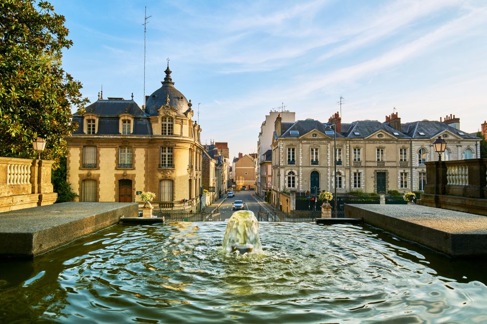
© Shutterstock
 Votre guide Ryo
Brittany: the 20 Must-See Places to Visit in 2026
Looking for places to visit in Brittany means confronting a region where the ocean is a constant presence, within 30 kilometres of any inland point. Yet its most powerful places are not all on the coast: an alignment of nearly 3,000 menhirs in the fields of Carnac, a legendary forest in the heart of the land, medieval walled towns whose ramparts have never been demolished. Whether you are planning a first trip or a deeper return visit, this article covers the 20 sites that deserve your time, from north to south, from the sea to the interior.
A few reference points to calibrate your stay: Saint-Malo has 6.6 kilometres of walkable ramparts, Carnac lines up nearly 3,000 menhirs over more than 4 kilometres, the gulf of Morbihan contains around forty islands (only two of which are permanently inhabited) among nearly 300 islets, and the Crozon peninsula has 70 kilometres of coastal paths between two rias. To explore the towns on foot with full commentary, the Ryo audio-guided tour of Saint-Malo À l'abordage covers 29 points of interest in 2h40 — a great starting point for grasping the historical depth of the region.
This article is structured by destination rather than by département. Each section gives the must-sees of the location, the best ways to visit and an honest estimate of the time required. The final section answers practical questions: when to go, how to organise your trip, how many days to allow.
Saint-Malo: the Corsair City and Its Ramparts
There is one thing photographs fail to convey: the height of the ramparts of Saint-Malo as seen from inside the intra-muros. The walls rise 9 metres above the level of the low rooftops, and when you walk along the chemin de ronde, the sea disappears to the north, replaced by grey slate roofs. This is a city built for defence, reconstructed to 80% after the 1944 bombings, but rebuilt stone by stone to an identical design using pre-war plans.
Walking the ramparts is free and accessible on foot from the Grande Porte or the Porte Saint-Vincent. Allow 1h15 for the full circuit (1.8 km of chemin de ronde), with stops at the bastions overlooking the Fort National, a Vauban fortress set on a rock exposed at low tide, accessible on foot only when tidal coefficients exceed 70.
Inside the walls, the cathédrale Saint-Vincent is less spectacular than its reputation suggests, but it contains contemporary stained-glass windows by Jean Le Moal that are surprisingly modern in feel. Just behind it, the rue de Dinan is lined with crêperies and stalls selling fresh galettes-saucisse, the local snack sold at Breton markets every weekend.
To go beyond the historic centre, the district of Rothéneuf is worth an extra 2 hours. Five kilometres east of the intra-muros, Abbé Fouré carved more than 300 figures directly into the granite rocks between 1894 and 1910. The result sits somewhere between outsider art and monumental sculpture, and was listed as a historic monument in 2017. A Ryo article covers this site in detail.
Plage de Bon-Secours (Rue de la Tour du Bonheur, 35400 Saint-Malo, rated 4.6/5 on Google with 1,383 reviews) is the intra-muros beach, 200 metres from the Grande Porte. Its natural swimming pool carved into the granite fills at high tide. Outside the season it is practically deserted — one of the quietest spots in the city.
To explore Saint-Malo with all its historical layers — corsairs, the slave trade, Chateaubriand, the Compagnie des Indes — the Ryo audio guide À l'abordage offers 29 audio tracks along a 6.6 km route, covering the full intra-muros walk and its surroundings.
Recommended duration: 1 day for the intra-muros and ramparts. 2 days to add Rothéneuf, Dinard (accessible in 10 minutes by ferry shuttle), and Cancale (15 km to the east).
Rennes: the Medieval Capital That Acts Like a Southern City
Rennes surprises those who arrive expecting a grey administrative city. The reality is quite different: the streets of the historic quarter rank among the best-preserved in all of France, with 87 half-timbered houses dating from before the great fire of 1720, and those that burned were rebuilt in stone, creating a striking contrast between the two banks of the Vilaine.
The marché des Lices has been held every Saturday morning since the 14th century. It is the second-largest open-air market in France after Rungis (in terms of direct producers present), with around 300 permanent stalls. You will find charcuterie, Breton cheeses, kouign-amann, Cancale oysters sold by the dozen, and an atmosphere that alone justifies choosing to arrive in Rennes on a Saturday.
The parlement de Bretagne is the city's landmark building. Built between 1618 and 1655, it is one of the few public buildings from the Ancien Régime to have survived both of the city's fires. Its gold-leaf ceilings, Gobelins tapestries and grand staircase are accessible on a guided tour (booking recommended in high season). Opposite, the place du Parlement de Bretagne is the gravitational centre of Rennes' nightlife.
The Musée des Beaux-Arts de Rennes is often underestimated. Its collection spans ancient Egypt to the 20th century, with a section devoted to Breton painters of the late 19th century — Gauguin before Tahiti, Sérusier, the Nabis — offering a fresh reading of the relationship between light and landscape.
For fans of contemporary architecture, the Champs Libres (designed by Christian de Portzamparc) house the public library, a museum of Brittany and a planetarium. It is the counterpoint to the historic centre, a 10-minute walk away.
Rennes is also the logical gateway to the region for those arriving by train (Paris Montparnasse in 1h25 by TGV). The Rennes audio-guided tour offers 26 audio tracks over 4.7 km, covering the old town, the parliament and the lively neighbourhoods — a great tool for a first encounter with the city on arrival at the station.
Recommended duration: 1 full day. 2 days if you want to explore the surrounding villages.
Quimper: the Heart of Cornouaille
Crossed by the Odet and its tributary the Steïr, Quimper is a city built on water. The two rivers meet right in the historic centre, at the foot of the cathedral, creating views of the quays lined with medieval corbelled houses that change completely depending on the season.
The cathédrale Saint-Corentin is the central monument. Its nave is slightly offset from the chancel, a construction defect dating from the 13th century, most likely caused by the presence of an earlier chapel that had to be worked around. The two spires added in the 19th century give it a recognisable silhouette visible from throughout the medieval streets.
The Musée des Beaux-Arts in Quimper holds one of the most significant collections of Breton painting associated with the Pont-Aven school: Gauguin, Émile Bernard, Maurice Denis. The Pont-Aven movement (named after the village some thirty kilometres to the south-east) profoundly transformed European painting in the late 19th century, and Quimper preserves its most publicly accessible traces.
The faïenceries HB-Henriot have been producing since the early 18th century. The guided workshop tour shows painters at work on traditional Breton motifs (Quimper remains one of the last places in Europe where this hand-painted faience technique survives). The factory shop offers slightly imperfect pieces at reduced prices.
To discover the medieval lanes and both banks of the Odet with commentary on the history of Cornouaille, the Ryo audio-guided tour of Quimper covers 23 points in 1 hour over 2.5 km — ideal for a half-day of discovery.
Recommended duration: half a day to 1 day.
Brest and the Crozon Peninsula
Here is something many people do not know about Brest: it is one of the rainiest cities in France (around 180 rainy days a year on average), yet it also has one of the largest ocean discovery centres in France, a harbour rated among the most beautiful bays in the world, and a national maritime museum housed in a medieval castle. Its reputation as a grey military city is only part of the story.
The château de Brest is the only monument in the city to have survived the 1944 bombings. Built on a rocky promontory overlooking the harbour since antiquity (the earliest fortifications date from the Roman period), it has housed the national maritime museum since 1958. The terrace offers a direct view over the rade de Brest, a vast sheltered stretch of water connected to the Atlantic by the goulet, a 2 km-wide channel guarded by several forts.
Océanopolis is the second must-see. This ocean discovery park has three pavilions (tropical, polar and temperate) with thousands of marine animals, including penguins, sea otters and sharks. Allow 4 to 5 hours.
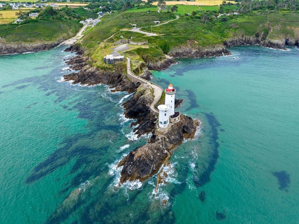
The Crozon peninsula is accessible in around fifty minutes from Brest by road, or by boat via the harbour. It is a narrow strip of land wedged between the rade de Brest, the bay of Douarnenez and the Atlantic. It concentrates some of Brittany's most spectacular coastal scenery: the pointe des Espagnols facing the goulet, the pointe de Pen-Hir (Pointe de Pen-Hir, 29160 Camaret-sur-Mer, rated 4.8/5 on Google with 6,700 reviews) and its quartzite cliffs, the cap de la Chèvre and its views over the bay of Douarnenez in clear weather.
The GR34, the customs officers' path that runs along the entire Breton coastline (over 2,000 km in total), crosses the peninsula for around 70 km. Even walking just a single day's segment (Morgat to Camaret, approximately 4 hours) gives a sense of the diversity of landscapes: cliffs, white sandy beaches, heather moorland, Vauban forts.
To explore Brest in depth, from its maritime history to its post-war reconstruction, the Brest audio-guided tour offers 28 audio tracks over 8.2 km — the longest route among the Breton destinations covered by Ryo.
Recommended duration: 1 day for Brest, 1 day for the Crozon peninsula.
The Gulf of Morbihan
The gulf of Morbihan is an inland sea. It is connected to the Atlantic by a narrow passage between the headland of Kerpenhir and the headland of Locmariaquer where, on a rising tide, the current reaches several knots, making it one of the trickiest passages on the Breton coastline for sailing boats. Inside, the waters are calm, threaded by channels and dotted with around forty emergent islands (only two of which, the île aux Moines and the île d'Arz, are permanently inhabited) among numerous islets.
The logic of the gulf is best understood from above. The Tumiac belvedere (also known as the tumulus de César), north of Arzon, offers a 360° panorama over the entire stretch of water. It is a Neolithic cairn easily reached on foot from a car park.
The île aux Moines and the île d'Arz are the two most accessible islands. The île aux Moines is reached in 5 minutes from Port-Blanc (frequent ferries in summer), the île d'Arz in around fifteen minutes from Vannes-Conleau. Both are virtually car-free, crossed by footpaths that circle the island in 3 to 4 hours.
The cairn de Gavrinis (Île de Gavrinis, 56870 Larmor-Baden, rated 4.6/5 on Google with 884 reviews) is perhaps the most impressive megalithic site in the gulf, and one of the best preserved in Europe. The interior of the funerary passage is entirely covered with Neolithic engravings — spirals, chevrons, axe imprints — on most of its slabs. Access is by boat only from Larmor-Baden (guided tours are compulsory; booking is recommended).
In practical terms, Vannes is the logical base for exploring the gulf. The city sits at the northern end of the stretch of water, has all the tourist infrastructure, and ferries to the islands depart from several ports around the gulf. A Ryo article covers the most beautiful spots in the gulf of Morbihan in detail.
Recommended duration: 1 to 2 days depending on the number of islands and sites to explore.
Vannes: Brittany's Best-Preserved Ramparts
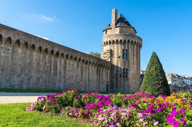
Vannes is one of the Breton towns that has kept its medieval walls in the most complete condition. The ramparts, built between the 13th and 15th centuries, are still visible along a large portion of their original perimeter. The most photographed stretch runs alongside the jardins de la Garenne, at the foot of the Poudrière and Connétable towers, with the half-timbered houses of the Saint-Patern quarter in the background.
The cathédrale Saint-Pierre is the central monument of the old town. Its treasury holds the relics of Saint Vincent Ferrer, a Valencian preacher who died in Vannes in 1419 and whose canonisation was one of the major diplomatic events of the Duchy of Brittany in the 15th century. The detail matters: he is one of the rare saints whose relics remained in the city where he died, never having been moved.
The place Henri IV features the town's best-documented half-timbered houses (16th century), some with carved figures on the facade beams. The Saturday morning market spills into the surrounding streets, with producers from the gulf and the Rhuys peninsula.
To walk the ramparts, the old town and the harbour quays with full commentary on the history of the Duchy of Brittany, the Ryo audio guide for Vannes offers 18 audio tracks over 3 km — a short, dense route.
Recommended duration: half a day to 1 day.
Carnac: Nearly 3,000 Menhirs and Unanswered Questions
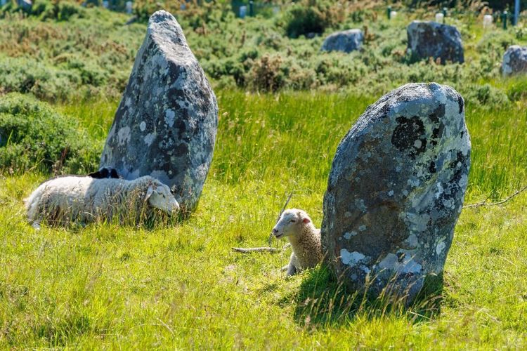
Carnac has the largest megalithic complex in the world. The alignments stretch for more than 4 km across the countryside north of the village, with three main fields — Ménec, Kermario and Kerlescan — totalling nearly 3,000 standing stones erected between the 5th and 3rd millennia BCE.
The most accessible alignments (Ménec and Kermario) have been fenced off since 1991 to allow the vegetation to regenerate. Free access is only permitted outside the high season (generally from October to March) during time slots defined by the site's managing authority. In summer, paid guided tours allow entry into the enclosures.
The musée de Préhistoire in Carnac is one of the richest in Europe on the subject. It puts these constructions in context: who were these peoples, how did they move blocks weighing several tens of tonnes over long distances, and above all why this density of megaliths within a 10 km radius of the village? No definitive answers, but the hypotheses presented are well grounded.
The Grande Plage of Carnac, a few kilometres south of the alignments, is one of the longest beaches in the Morbihan, with water that warms up in July and August thanks to the sheltered configuration of the Quiberon bay.
Recommended duration: half a day for the alignments and the museum; 1 day if you add the beach and the secondary tumuli.
The Côte de Granit Rose and Ploumanac'h
The Côte de Granit Rose stretches for about fifteen kilometres between Perros-Guirec and Trébeurden, in the Côtes-d'Armor. The colour of the rocks is not a photographic illusion: the granite contains potassium feldspars that turn pink-orange when exposed to marine erosion over millennia. The boulders, worn into shapes that human imagination has always found names for (the Tortoise, Napoleon's Hat, the Stack of Crêpes), reach several metres in height in places.
The most spectacular spot is Ploumanac'h, a few kilometres west of Perros-Guirec. The coastal path (GR34) between the plage de Saint-Guirec and the Mean Ruz lighthouse winds through the boulder chaos for nearly 3 km — one of the most frequented coastal paths in Brittany in July and August, and for good reason.
The Sept-Îles nature reserve is visible from the coast, a few kilometres offshore. It is one of the largest ornithological reserves in metropolitan France, with the largest French colony of Atlantic puffins, as well as gannets, guillemots and razorbills. Boats from Perros-Guirec allow you to approach the islands without landing in the protected zone (crossing time: 30 to 45 minutes). Before heading for the coast, our audio-guided tour of Rennes gives a first taste of Breton history.
Trégastel and Trébeurden are two less crowded alternatives to Perros-Guirec, with family-friendly beaches and less congested access to the GR34 in high season.
Recommended duration: 1 day for Ploumanac'h and the coastal path, plus half a day for the Sept-Îles if the weather allows.
The Pointe du Raz and Cap Sizun
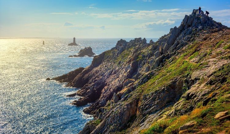
The pointe du Raz (Pointe du Raz, 29770 Plogoff, rated 4.6/5 on Google with 2,049 reviews) is one of the most iconic sites at the tip of Brittany, at the western end of cap Sizun. It closes the horizon to the west over the Atlantic, with almost nothing between you and the open sea. It is not the westernmost point of mainland France (the pointe de Corsen, further north, claims that geographical distinction), but it is one of the most visually spectacular: 70-metre cliffs exposed to the wind off the ocean, with the silhouette of the île de Sein some fifteen kilometres away.
The site, awarded the Grand Site de France label, is managed to protect the moorland: the car park has been moved back about 1 km from the cliffs to allow the vegetation to regenerate. Access is on foot (shuttle in high season). The circular path around the headland covers a few kilometres, facing the prevailing winds.
The cap Sizun, of which the pointe du Raz is the tip, also shelters colonies of nesting seabirds. The réserve du cap Sizun (managed by Bretagne Vivante) protects cliffs between Goulien and the pointe du Millier — free access but the path may be closed during the nesting season (spring).
Recommended duration: half a day for the pointe du Raz.
The Forest of Brocéliande
Brocéliande is not a myth — it is a very real forest of several thousand hectares in the centre of Ille-et-Vilaine, officially known as the forêt de Paimpont. Since the Middle Ages, the Arthurian texts of Chrétien de Troyes and Wace have placed Merlin, Viviane and the enchanted lake here, and this literary palimpsest has profoundly shaped the way people visit this woodland.
The must-see 'Arthurian' sites are the Val sans Retour (a steep valley criss-crossed by paths, the scene of Morgan's trap in medieval texts), the fontaine de Barenton (Forêt de Paimpont, 35380 Concoret, rated 4.4/5 on Google with 1,317 reviews) (a mysterious spring in the heart of the forest) and Merlin's tomb, two stone slabs covered with offerings left by visitors. None of these sites has any proven historical connection to the legends, but the atmosphere of the forest — dense oak groves, bracken-covered moorland, morning mist — effectively sustains the suggestion.
The château de Comper, on the edge of the pond, houses the Centre de l'Imaginaire Arthurien, with seasonal exhibitions on Celtic legends and their modern reinterpretations.
Recommended duration: half a day to 1 day depending on your appetite for hiking.
The Breton Islands
Brittany has several dozen inhabited islands, each with a radically different character. Here are four that stand out for their accessibility and interest.
Belle-Île-en-Mer (Le Palais, 56360 Belle-Île-en-Mer, rated 4.9/5 on Google with 10 reviews) is the largest island in Brittany (85 km², around 5,400 permanent residents). The crossing from Quiberon takes around fifty minutes. The island combines in a single space the wild coastline (cliffs on the Atlantic side) and the sheltered coves of the lee coast. Monet painted here in 1886, captivated by the light on the needles of Port-Coton. The citadelle Vauban at Le Palais is open to visitors.
L'île de Sein lies about fifteen kilometres from the pointe du Raz. A few hundred inhabitants, no cars, almost no trees, a highest point a few metres above sea level. In June 1940, following General de Gaulle's appeal, almost all the able-bodied men on the island (around 128 people) joined the Free French in London — a proportion unique in the history of the Resistance, which earned the island the Croix de la Libération. The crossing from Audierne takes just over an hour.
L'île d'Ouessant is the most exposed to the elements: a storm-swept climate, the Créac'h lighthouse ranked among the most powerful in the world, a population of a few hundred in winter. It is reached from Brest (approximately 2h15 by ferry) or Le Conquet (just over an hour).
L'île de Groix is less visited than Belle-Île but offers something rare in Europe: the plage des Grands Sables, one of the few convex beaches in the world (it curves outward towards the ocean rather than inward towards the land). The crossing from Lorient takes around 45 minutes.
Recommended duration: a minimum of 1 day per island. For Belle-Île, 2 days are needed to circuit the island.
Guérande and the Guérande Peninsula
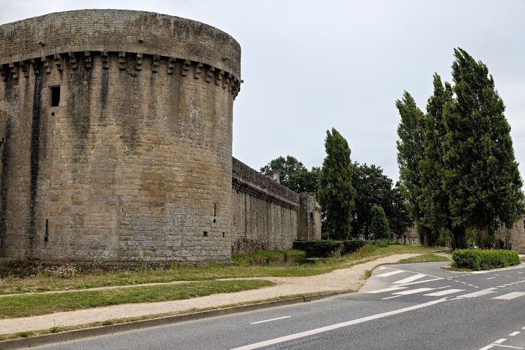
Guérande is technically in Loire-Atlantique, but it is culturally and historically Breton. Its 15th-century ramparts are among the best preserved in the entire west of France: an almost intact enclosure with its gatehouses, main towers and chemin de ronde, in a remarkable state of repair.
The salt marshes are the other reason to come. The paludiers (salt producers) harvest fleur de sel by hand in summer from the marshes surrounding the peninsula. The Maison des Paludiers in Saillé explains the production process and offers guided tours of the marshes in season.
The medieval village intra-muros is compact but dense: the collégiale Saint-Aubin, the cobbled lanes, the old market halls. An hour is enough to walk it all, but you tend to linger in the fine food shops selling salt, salted butter caramel and artisan preserves.
The Ryo audio-guided tour La Clé de la Bretagne in Guérande offers 14 audio tracks over 1 km — a perfect, concentrated introduction to the medieval history of the walled city.
Recommended duration: half a day for the medieval city and the salt marshes in season.
Cancale, Dinard and the Côte d'Émeraude
The Côte d'Émeraude stretches from Saint-Malo to cap Fréhel, along some sixty kilometres of coastline. Its name comes from the colour of the water at favourable times of day: a translucent green caused by the nature of the shallow seabed.
Cancale is 15 km east of Saint-Malo, on the edge of Mont-Saint-Michel bay. It is the oyster capital of northern Brittany: the oyster beds in the bay produce several thousand tonnes a year, and the oyster market (at the foot of the Houle lighthouse) sells fresh shellfish at any hour, eaten standing at the water's edge. On a clear day the view from the headland takes in Mont-Saint-Michel.
Dinard is on the other side of the Rance estuary, 10 minutes from Saint-Malo by ferry shuttle. It is a Belle Époque seaside resort: hundreds of Anglo-Norman villas built between the mid-19th century and 1914 by British and American visitors who had discovered the coast. The promenade du Clair de Lune, along the seafront, remains the most photogenic promenade in the resort.
The cap Fréhel (Cap Fréhel, 22240 Fréhel, rated 4.7/5 on Google with 3,344 reviews) is the other end of the Côte d'Émeraude. Its red sandstone and schist cliffs drop several tens of metres into the sea, and the ornithological reserve at the foot of the cliffs shelters nesting seabirds (guillemots, puffins, fulmars). The path from the car park to the headland is short (around twenty minutes), but the panorama over the coast and the fort la Latte (a medieval castle perched on a rock a few kilometres to the south-east) makes the detour entirely worthwhile.
Recommended duration: 1 day for Cancale, Dinard and the Rance estuary; an additional half-day for cap Fréhel.
When to Go, How Many Days, How to Organise Your Trip

The Best Time to Visit Brittany
Brittany is an all-year destination, but the choice of period radically changes the experience. July and August are the busiest months: the beaches are swimmable (water at 17–20°C), all attractions are open and festivals follow one after another (the Festival Interceltique de Lorient in August draws hundreds of thousands of visitors). The downside: accommodation prices rise sharply, and some coastal paths (Ploumanac'h, pointe du Raz) can become overcrowded.
May–June and September are probably the best windows. The summer light is already there, temperatures are mild (15–20°C), the water is beginning to warm up, and prices remain reasonable. Local markets are in full swing, Cancale oysters are at their best (spring and autumn), and the roads are manageable.
October–November appeals to lovers of moorland and rough seas. The autumn light on the Côte de Granit Rose or at Ouessant is of exceptional quality. The islands are almost deserted by tourists. But some accommodation closes, and crossings to the islands can be cancelled for several days at a time by storms.
Winter (December–February) is for the initiated: mild temperatures for the season (8–12°C in Brest, rarely below 5°C), historic towns without crowds, a particular atmosphere in the harbours. But the weather can be difficult and some sites significantly reduce their opening hours.
How Many Days to Allow?
3 days: Saint-Malo plus Mont-Saint-Michel (on the Breton side) plus Cancale. The minimum for a first taste of northern Brittany from Paris.
7 days: the classic circuit. Saint-Malo (1 day) → Rennes (1 day) → north coast Perros-Guirec and Ploumanac'h (1 day) → Brest and Crozon (2 days) → Quimper (1 day) → Vannes and Carnac (1 day).
10 days: add Belle-Île (2 days), one island of your choice (Ouessant from Brest, or Sein from Audierne), and the gulf of Morbihan (1 extra day). This also allows you to slow down in Guérande and explore without too tight a schedule.
14 days: the complete Brittany, with Brocéliande, the Côte d'Émeraude, and the lesser-known villages of the hinterland (Josselin, Dinan, Concarneau).
Logistics and Transport
A car is virtually essential as soon as you leave the major cities. Rennes is the city best connected by the TER network to the rest of the region (Quimper, Brest, Saint-Malo and Vannes are all accessible by train from Rennes). But the natural sites — the Crozon peninsula, Brocéliande, cap Fréhel, the gulf of Morbihan — are only accessible by car or bicycle.
Electric bikes are a serious alternative for the Crozon peninsula (hilly terrain but manageable distances) and the gulf of Morbihan (cycle path network around the stretch of water).
Accommodation: Where to Base Yourself?
For northern Brittany: Saint-Malo or Dinard as the main base. For Finistère: Quimper or Douarnenez. For the Morbihan: Vannes with quick access to the gulf. For a touring itinerary: do not look for a single base — stop for 2 nights per town.
FAQ
How Long Does It Take to Visit Brittany?
A minimum of 7 days is needed to cover the main sites across the four zones: northern Brittany (Saint-Malo, Côte d'Émeraude), Finistère (Brest, Crozon, Quimper), Morbihan (Carnac, the gulf, Vannes) and the interior (Rennes, Brocéliande). For a comfortable pace without rushing between sites, 10 to 14 days is the optimal duration.
What Are the Best Places to Visit in Brittany in 3 Days?
In 3 days from Paris, Saint-Malo is the most rewarding choice in terms of travel time versus content (1h25 by TGV to Rennes, then 1 hour by coach or regional train). Suggested itinerary: day 1 Saint-Malo intra-muros and ramparts, day 2 Cancale, Dinard and cap Fréhel, day 3 Rennes and its marché des Lices. If you arrive by car, add Mont-Saint-Michel on the Norman side (about thirty kilometres east of Cancale).
What Is the Best Season to Visit Brittany?
May–June and September are the best periods for combining good weather, access to all sites, and reasonable prices. July–August offers warmth and all the events but with maximum crowds. Winter (November–March) is less well known but offers unique experiences: deserted moorlands, historic towns without the crowds, autumn light on the coastline.
Is It Better to Rent a Car to Visit Brittany?
Yes, as soon as your itinerary includes anything beyond the major cities. The TER network connects Rennes to Saint-Malo, Brest, Quimper and Vannes without a car. But the Crozon peninsula, the Carnac alignments, the Côte de Granit Rose, the gulf of Morbihan or the forest of Brocéliande all require a vehicle. Car hire is available from Rennes (TGV station with immediate pick-up) or in the major coastal towns.
What Are the Most Magical Places in Brittany?
The places that leave the greatest impression on visitors are generally the Côte de Granit Rose (Ploumanac'h), the gulf of Morbihan seen from the Tumiac belvedere, the Carnac alignments at sunrise before the tour groups arrive, the île de Sein in rough seas, and the forest of Brocéliande in misty weather. The urban sites that consistently exceed expectations are Saint-Malo and Guérande.
Where Can You See Unique Landscapes in Brittany?
The Crozon peninsula concentrates the most varied landscapes in a small area: quartzite cliffs, heather moorland, immaculate sandy beaches, sheltered roadsteads. The Côte de Granit Rose is unique in Europe for the colour of its rocks. The gulf of Morbihan is visually unmatched in metropolitan France for its combination of water, islands and light.
Brittany is a region that is hard to summarise. Its coastline changes every few kilometres — pink granite in the Côtes-d'Armor, quartzite cliffs in Crozon, mudflats and salt marshes in the Morbihan. Its towns share a common historical density: ramparts unchanged since the Middle Ages, cathedrals whose foundations date back to the earliest Breton bishoprics, markets held in the same spot for several centuries.
To prepare your visit with audio guides by city, the Ryo platform covers the main Breton destinations: Saint-Malo, Rennes, Quimper, Brest, Vannes and Guérande each have an audio-guided tour lasting from 1 hour to 3h15. A great way to enrich each stop without getting lost in paper guidebooks.
À lire également