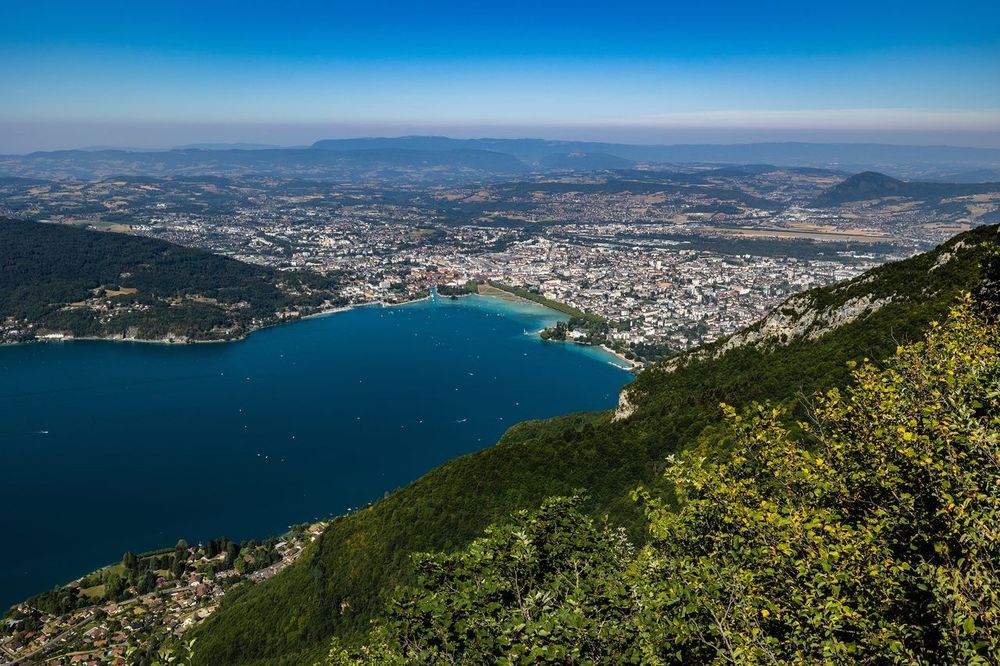
© Shutterstock
 Votre guide Ryo
The 9 Most Beautiful Hikes Around Annecy in Winter 2026
Tourists arrive in summer, suitcases full of beach expectations. Those who return in winter understand something the others don't: Lake Annecy locked in the morning cold, the Aravis summits blanketed in fresh snow and the silence of frost-covered beech forests make up a setting that simply does not exist in high season. Winter hiking around Annecy is exactly that: a mountain stripped of its crowds, far more accessible than most newcomers imagine.
Between December and March, conditions transform every route. The Angon waterfall can be partially frozen like an ice sculpture suspended from the limestone cliff. The plateau des Glières, at over 1,400 m in altitude, opens onto immaculate expanses crossed by Resistance fighters in 1944. The panorama from Mont Veyrier over the lake ringed with white is well worth the climb. Other trails remain accessible in simple waterproof shoes, such as the Poisy marshes loop or the lakeside path at Duingt. There is something for every level, from a Sunday family outing to the hiker looking to rise above the low clouds.
Nine routes make up this selection, chosen for their specific winter appeal: snowy views over the lake, frozen waterfalls, open ridges above the clouds and unspoilt nature on the plain. To explore Annecy between mountain outings, the Ryo audio guide La Venise des Alpes retraces the history of Vieux Annecy in 20 audio stages over 2.6 km: a way to rest your legs while crossing one of the best-preserved medieval centres in the French Alps.
Mont Veyrier: Lake Panorama at 1,291 m
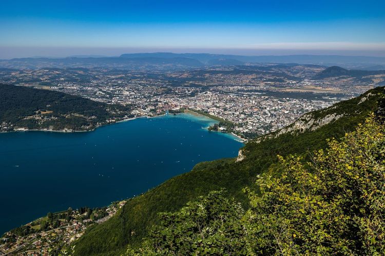
The Mont Veyrier hike (Col de Veyrier, 74290 Veyrier-du-Lac, rated 4.8/5 on Google with 151 reviews) is the locals' winter favourite. Accessible from the Col de Veyrier, less than 10 minutes by car from the centre of Annecy, it offers in under 3 hours round trip one of the most striking viewpoints in the Bauges massif: Lake Annecy seen head-on, with Annecy-le-Vieux below and, on a clear day, Mont Blanc visible behind the eastern ridges. This hike above Annecy-le-Vieux, climbing steeply above the village, remains one of the most popular in the area.
The route starts from the Col de Veyrier car park (847 m), a natural saddle between Veyrier-du-Lac and Menthon-Saint-Bernard. In winter, this car park remains accessible by ordinary car in most conditions: the road leading to it is cleared of snow by the department even after significant snowfall. From there, a marked trail climbs in switchbacks through a forest of oaks and beeches toward the summit ridge. The elevation gain is approximately 450 m over 3.5 km, with a steady profile that holds no surprises.
What changes in winter is the light. The low December and January sun bathes the limestone cliffs in an orange hue in the late afternoon that summer never produces. The white limestone ledges on the ridge, frosted in the morning, give off a particular brilliance as soon as the sun reaches them around 10 am. If the ridge is icy (common between January and early March), lightweight crampons such as microspikes are essential for the last 200 metres of ascent on the rock. Without them, it is better to stop at the first views through the forest: they are already remarkable and more than justify the outing.
At the summit, the view plunges down over Lake Annecy, the lakeside villages and the Tournette opposite. Choose a day with little wind rather than a sunny day with low-lying fog: in the Annecy winter, a temperature inversion can leave the town under cloud while the ridges bask in a clear sky above 1,000 m. Setting off around 9 am in the depths of winter leaves enough light to enjoy the panorama before noon and descend comfortably before dark. At the highest point, the concrete slab from the old Mont Baron cable car station, closed since 1930, is a reminder that a funicular once linked Veyrier-du-Lac to these ridges; today, only the crosses marking the ridge keep walkers company. The Mont Veyrier hike appeals equally to heritage enthusiasts and panorama seekers.
Level: Easy to intermediate | Elevation gain: +450 m | Distance: 7 km round trip | Duration: 2h30–3h | Access: Col de Veyrier car park, free.
La Tournette from Montmin: The Aravis Summit in Winter Conditions
At 2,351 m, la Tournette (Parking de l'Aulp, 74210 Montmin, rated 3.7/5 on Google with 38 reviews) is the highest point dominating Lake Annecy. In winter, the normal route from the Chalet de l'Aulp remains feasible in stable conditions, provided you are properly equipped and choose a rigorously clear weather window. This is the most committing route in this selection, reserved for experienced hikers who have already practised winter mountain hiking with crampons and ice axe.
The route starts from the hamlet of Montmin (1,048 m), accessible from Annecy via the D42 through Bluffy. In winter, this mountain road may be closed or snow-covered: consult InfoRoute 74 the evening before your departure. From the car park, the trail climbs first through mixed forest before tackling the alpine pastures of l'Aulp (1,504 m), the first wide-open spaces where snow accumulates to a good depth from December onwards. The forest shields from the wind up to this altitude, making the ascent more comfortable than the altitude figures might suggest.
Between l'Aulp and the Tournette refuge (1,975 m, closed from November to May), the terrain becomes progressively more technical: steep slopes, rocky sections, risk of wind slabs in windy periods. Snowshoes are generally no longer sufficient from this zone onwards: rigid crampons suited to alpine conditions and good terrain-reading skills are required. The Météo-France avalanche risk bulletin must be consulted systematically before any outing on this north-north-east facing slope, one of the most exposed in the Aravis massif. After a snowfall of more than 30 cm in less than 48 hours, do not attempt it.
For hikers who wish to enjoy the setting without alpine commitment, climbing to l'Aulp only is a very rewarding alternative. The view at 1,504 m over Lake Annecy, the Semnoz and the Belledonne summits is more than enough, and the return from l'Aulp takes under 1h30. The total elevation gain from Montmin to l'Aulp is 460 m over 4.5 km. This intermediate option is ideal for regular hikers who do not have full winter alpine equipment.
If this area particularly interests you, the article on hikes at the Col de la Forclaz and Lake Annecy presents several variants suited to all levels in this same massif.
Level: Difficult (winter alpine climbing beyond the refuge) / Intermediate to l'Aulp | Elevation gain: +460 m (l'Aulp) / +1,303 m (summit) | Distance: 9 km round trip to l'Aulp | Duration: 3h (l'Aulp) / 6–7h (summit)
The Angon Waterfall: An Ice Sculpture Suspended from the Cliff
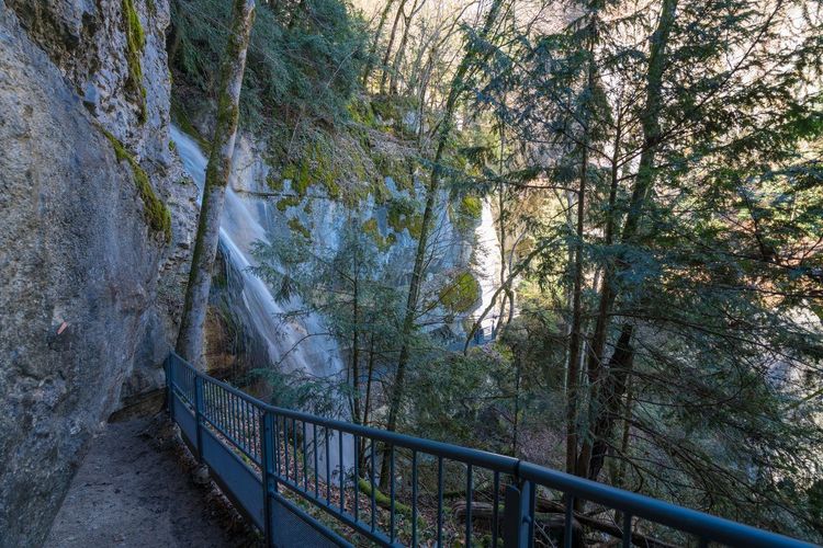
Few winter hikes offer such a spectacular destination for so little effort. The Angon waterfall (Sentier de la cascade d'Angon, 74290 Talloires-Montmin, rated 4.5/5 on Google with 1,386 reviews), in the commune of Talloires-Montmin, drops nearly 60 m from the limestone cliffs into a mixed forest setting that, in January, can be draped in ice stalactites forming an impressive mineral structure. During very cold spells (five consecutive nights at -5°C or below), the waterfall partially freezes and offers a spectacle that few waterfalls in the French Pre-Alps can match over such a short walking distance.
The trail starts from the village of Talloires, on the eastern shore of the lake. From the harbour, follow the Route du Crêt to the sign indicating the waterfall (about 10 minutes on foot from the car park). The marked path climbs steadily through dense woodland of chestnuts and oaks, sheltered from the wind by the canopy. The elevation gain is only 200 m over 3 km round trip, making it one of the most accessible hikes in this selection, including for families with children from age 6–7.
In winter, two areas deserve particular attention: the first few metres of the trail after the road, often icy in the morning due to complete shade, and the area at the base of the waterfall where frozen water spray makes the rocks very slippery. Lightweight microspikes are sufficient to make these two sections safe. Do not approach beneath the waterfall in hard frost: ice stalactites can break off without warning.
What makes this walk particularly interesting in winter is also the view over the lake from the heights of Talloires. By climbing slightly from the waterfall toward the belvedere of the Chapelle Saint-Germain-des-Vignes, you discover Talloires from above with the lake and the Aravis as a backdrop. A viewpoint that summer drowns in vegetation and that winter reveals in its full extent.
Talloires is accessible from Annecy by bus (Sibra network, on weekdays) or by car in 20 minutes along the Corniche road. In winter, the village entrance car park is free and rarely full, even on sunny weekends.
Level: Easy | Elevation gain: +200 m | Distance: 3 km round trip | Duration: 1h30–2h | Access: Village of Talloires, free car park.
Le Semnoz: Snow-Covered Forest and Sweeping Panorama at 1,704 m
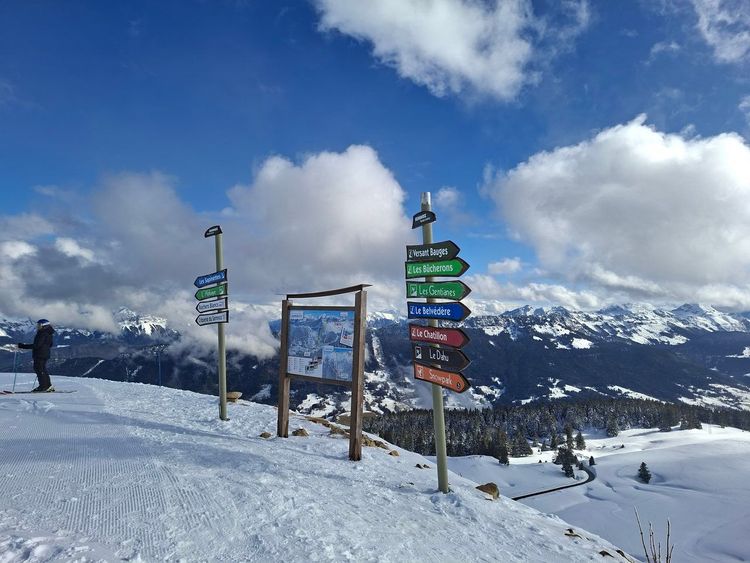
The Semnoz (Route du Semnoz, 74000 Annecy, rated 4.8/5 on Google with 50 reviews) is the massif that borders Annecy to the south-west, rising gradually from the city's outskirts to 1,704 m at the Crêt de Châtillon. In winter, it is at once a small cross-country and downhill ski resort, a popular spot for ski tourers, and exceptional hiking terrain on its wooded slopes. The forest trail from the heights of Seynod to the summit is one of the most remarkable walks within immediate reach of Annecy: you start in the city and arrive at the top of the Bauges without ever leaving the continuity of the paths.
Two main access points are possible. From Annecy-Seynod on foot (elevation gain of 850 m over 8 km, a long but entirely forested and gradual route) or from the Croisette car park (1,250 m) by car if the road is open. In the event of heavy snowfall, the D41 may be closed above the Croisette: check via InfoRoute 74 before setting out. From the Croisette, the climb to the Crêt de Châtillon is only 450 m of elevation gain over 4 km.
The forest trail along the north-facing slopes of the Semnoz passes through a beech-fir woodland that often holds powdery snow between the trees while the ridges are swept by the wind. It is one of the rare spots around Annecy where hiking in fresh snow remains possible for the maximum number of days in winter. Set off early in the morning: before 10 am, packed snow stays softer; afterwards, overnight refreezing turns it into a hard, slippery surface on exposed sections. The forest also shelters roe deer and chamois that descend to lower altitudes in winter — frequent encounters on the first kilometres from Seynod.
At the summit, the orientation table at the Crêt de Châtillon offers a 360° panorama over the lake, the Aravis chain, the Vercors and the Belledonne range. On a clear day, Mont Blanc rises behind the Bornes ridges. Skiers, snowshoers and crampon-wearing hikers share this summit plateau in a convivial winter atmosphere. The Auberge de la Croisette stays open in winter, making a warm lunch at altitude before the descent a genuine option.
Level: Intermediate | Elevation gain: +450 m from the Croisette / +850 m from Seynod | Distance: 8 km round trip from the Croisette | Duration: 3h–4h | Access: Croisette car park, D41 road (open depending on snow conditions).
The Chemin des Châteaux: Seven Centuries of History on the Eastern Shore Ridges
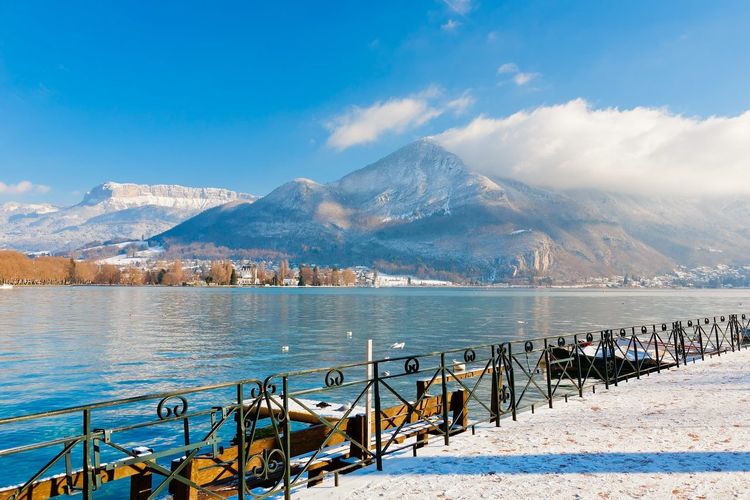
Less well known than the high-mountain routes, this walk links the medieval villages of the lake's eastern shore along an old communication route between the region's castles. In winter, stripped of its foliage, the forest opens up to reveal permanent views over the lake that summer vegetation completely conceals from June to October. It is one of the most striking examples of winter revealing what summer hides.
The most convenient starting point is Menthon-Saint-Bernard (free car park in the village in winter). The Château de Menthon, still inhabited by the de Saint-Bernard de Menthon family since the 11th century and open for visits in season, dominates the lake from its medieval towers at 610 m in altitude. The trail heads into the forest behind the château and climbs toward the ridges along limestone cliffs where winter solifluction has carved spectacular geological forms that the snow accentuates.
This trail is one of those our Annecy audio walking tour evokes through the history of the Counts of Genevois, who controlled the lake route from these heights during the Middle Ages. Winter is the ideal season to explore it: the trails are lightly used, the frosted limestone traces structures that vegetation masks in summer, and the view over the lake with the snowy Aravis as a backdrop is a setting that few hikers know. The orange and green lichens colonising the limestone rocks are particularly vivid in winter, forming patterns that go unnoticed during the tourist season.
Allow 3 to 4 hours for the full loop from Menthon with a return along the lakeshore. The total elevation gain is 380 m, reasonable even in normal winter conditions. The terrain is well marked throughout (yellow waymarking from the Annecy tourist office). On fresh snow, microspikes are useful on the ridge sections but not compulsory for the rest of the route.
Level: Easy to intermediate | Elevation gain: +380 m | Distance: 10 km loop | Duration: 3h30–4h | Access: Village car park at Menthon-Saint-Bernard, free.
The Poisy Marshes: A Gentle Walk on the Annecy Plain
For days when the mountains are shrouded in cloud or snowfall is too unpredictable, the Poisy marshes (Marais de Poisy, 74330 Poisy, rated 4.8/5 on Google with 6 reviews) offer a surprisingly rewarding lowland alternative. These Natura 2000 wetlands, 8 km west of Annecy, are among the last alluvial marshes on the Savoyard plain. In winter, they make an exceptional birdwatching site: grey herons, wigeon, kingfishers and common snipe frequent these areas throughout the cold season.
The discovery trail is entirely flat, marked and 4 km long as a loop. It follows the banks of the Usses (the river that feeds the marshes) before crossing wet meadows that freeze in winter, creating firm and pleasant ground underfoot. No specific equipment is required, even after a night of frost. This hike is perfectly suited to families with young children, people with limited mobility and anyone looking for a relaxed outing of under 2 hours. Binoculars are recommended to make the most of the winter wildlife. Free parking all year round at the site entrance, accessible from Annecy via the RD14.
Level: Very easy | Elevation gain: 0 m | Distance: 4 km | Duration: 1h15–1h30 | Access: RD14 from Annecy, Poisy marshes car park, free.
The Col de la Forclaz: A Winter Belvedere over the Bay of Talloires
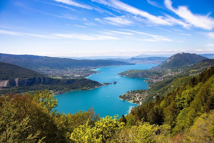
The Col de la Forclaz (1,150 m) is the iconic viewpoint over the bay of Talloires, reproduced on thousands of postcards and regularly cited among the finest panoramas in the French Alps. In winter, the paraglider gondola no longer runs and the col car park is often snow-covered, but that is precisely why this is the right time to climb it on foot: you will be almost alone facing one of the most photographed panoramas in the Alps.
From Talloires, the ascent on foot via the direct trail involves 500 m of elevation gain over 4 km. The trail first passes through vineyards and orchards (frost-covered in winter, glittering in the low morning light) before entering a beech forest with bare branches that let the light filter through the entire climb. Under normal winter conditions, waterproof hiking shoes are sufficient. With deep snow, microspikes are recommended for the last 200 metres before the col, where the terrain becomes more exposed to wind and overnight refreezing.
At the col, the view plunges simultaneously in both directions: on the lake side, the bay of Talloires and the Château de Duingt at the far end of the dark turquoise water; on the Aravis side, the north-east slopes tumbling down toward Montmin. On a clear day, the Tournette ridge closes off the horizon with its 2,351 m of snow. The contrast between the blue of the lake and the white of the summits produces here, in winter, an image that summer with its green tones cannot replicate.
An interesting variant from the col is to continue to the upper viewpoints of the Touvière, with an additional 200 m of elevation gain, giving even more perspective over the whole lake. The descent can follow a different route via the hamlets of Montmin, for a total loop of around 12 km. This geographic area is one of the richest in the region for hiking in all seasons. Back in town, Ryo's one-hour audio-guided loop through the old centre makes an easy contrast to a day on the trails.
Level: Intermediate | Elevation gain: +500 m | Distance: 8 km round trip | Duration: 3h–3h30 | Access: Village of Talloires, free car park in winter.
The Plateau des Glières: Memory and Open Skies at 1,440 m
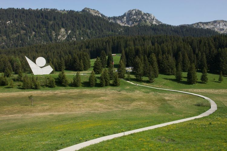
Some 30 km north-east of Annecy, the plateau des Glières (La Bombardière, 74130 Thorens-Glières, rated 4.5/5 on Google with 889 reviews) is a place apart in the winter landscape of Haute-Savoie. A vast limestone plateau reaching 1,440 m, it entered history in 1944 when nearly 500 Resistance fighters held out there through the winter against the Milice and the Wehrmacht before the final assault in March. The National Resistance Memorial, inaugurated in 1973 around a monumental sculpture by Émile Gilioli, makes it both a site of national remembrance and an exceptional hiking destination.
In winter, the plateau is also one of the most popular cross-country skiing and ski touring destinations in Haute-Savoie, with 30 km of marked trails. Hiking without snowshoes remains possible during periods of shallow snow (less than 30 cm) on compacted routes. Access from Thorens-Glières climbs to the welcome chalet at La Bombardière (1,360 m) along a road that stays open year-round except in exceptional conditions.
From La Bombardière, several marked loops cover the plateau in 2 to 4 hours depending on the distance chosen. The most recommended viewpoint is the Pré Fleuri area (1,430 m), from which the gaze stretches over the Aravis massifs and Mont Blanc. The memorial can be visited continuously year-round, and its brutalist architecture is an unexpected cultural highlight deep in the mountains. Allow time to visit the Maquis stele to understand the history of this place before or after the hike.
Plateau weather is often more exposed to wind than the valleys. A windproof jacket and warm gloves are essential, even in sunshine. In heavy snowfall, snowshoes become indispensable and can be hired at La Bombardière in season. If this area makes you want to explore Haute-Savoie more broadly, the article on the most beautiful hikes in Haute-Savoie offers routes beyond the Annecy basin.
Level: Easy to intermediate | Elevation gain: +80 m from La Bombardière | Distance: 6 to 12 km depending on loop | Duration: 2h–4h | Access: La Bombardière car park, Thorens-Glières, free.
The Duingt Loop: Lake Annecy Seen from Its Wild Shores
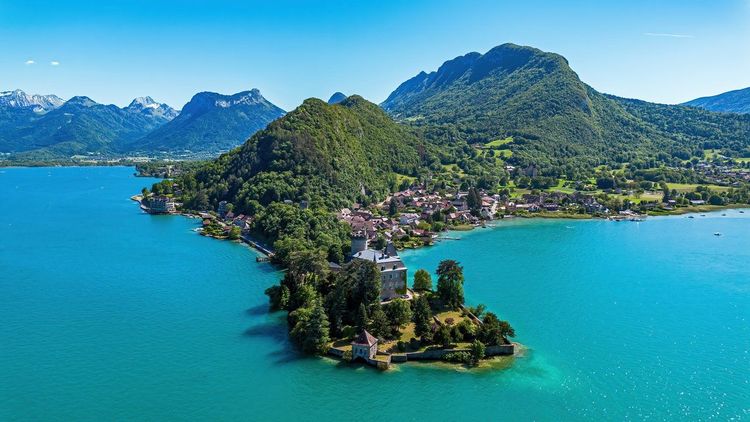
Duingt, a medieval village 15 km south of Annecy on the western shore, is guarded by the Château de Châteauvieux, an 11th-century fortress set on a small peninsula in the lake waters. The loop that follows the shores from Duingt to Saint-Jorioz and returns via the upper hillsides is one of the most accessible routes in the selection, and among the most contemplative.
In winter, the lake banks at this point are virtually deserted. The water takes on a deep dark green colour, the reeds of the Bout du Lac nature reserve shimmer in the cold light, and the snow-covered Bauges summits are reflected in the still waters. It is the kind of landscape photographers seek out and hikers too often overlook in favour of the heights.
The classic loop from the Duingt car park covers 8 km with an elevation gain of only 120 m. The trail first follows the shore along paths between the reeds and lakeside properties before climbing slightly onto the hillsides above Saint-Jorioz, then returning with an elevated view over the lake. No specific equipment is required beyond waterproof shoes: lakeside paths stay damp even without recent rainfall, and winter mornings can leave frost on the wooden boards of footbridges.
A longer variant (12 km) incorporates the natural trail through the Bout du Lac reserve, a protected wetland at the southern end of the lake and a remarkable winter habitat for waterfowl. Allow 3h30 for this extended circuit. To round out your stay with more ideas in the area, the article on activities in Annecy and its surroundings covers a broader range of year-round possibilities.
Level: Easy | Elevation gain: +120 m | Distance: 8 to 12 km depending on variant | Duration: 2h30–3h30 | Access: Duingt car park, free in winter.
Equipment and Safety for Winter Hiking Around Annecy
Winter hiking around Annecy requires a different level of preparation from the summer season. The mountains around Annecy in winter do not forgive improvisation, but they do not systematically demand a full alpine kit either. The region experiences contrasting winters: some weeks in January, low-altitude trails remain snow-free up to 800 m with frost only overnight. Other weeks bring 50 cm of fresh snow down to 1,000 m. The ideal equipment is therefore adaptable, not systematically heavy.
Essentials for all winter outings: waterproof hiking shoes (Gore-Tex membrane or equivalent), lightweight crampons such as microspikes (essential as soon as frost sets in on rocky or shaded trails), a layering system with a thermal base layer, fleece mid-layer and waterproof shell. Even on low-altitude trails such as the Angon waterfall or the Poisy marshes, winter mornings can drop to -8°C in shaded forest sections.
For hikes above 1,200 m (Semnoz, Forclaz, Tournette), add snowshoes or appropriate crampons depending on snow type, telescopic poles (invaluable on icy descents), a head torch with spare batteries (in Annecy in December, darkness falls at 4:30 pm), and a survival blanket. The Tournette beyond the l'Aulp refuge requires full winter alpine gear: 12-point rigid crampons and an ice axe. Do not attempt it with standard hiking equipment.
One often overlooked precaution: cold drains phone batteries very quickly (sometimes 50% loss in under an hour at -5°C). Keep your phone in a pocket close to your body and bring a power bank. For navigation, download your maps in offline mode before setting off: there is no signal on several of the routes in this selection.
On collective safety: check the Météo-France avalanche risk bulletin before any mountain outing, even for routes that appear straightforward. The north-facing slopes of the Aravis and Bauges are particularly exposed after heavy snowfall. Always let someone know your route and expected return time. If the weather turns unfavourable at altitude, it is also the right moment to download the Ryo app and explore the city of Annecy: the Ryo audio-guided tour La Venise des Alpes covers 20 points of interest in Vieux Annecy in one hour, without boots or microspikes.
Getting There and Practical Information

From Annecy: The city is connected to Paris in 3h40 by TGV (Paris Gare de Lyon, with a connection at Chambéry). From Lyon, allow 1h40 by train or 1h15 by car via the A41 motorway. In winter, parking in departure villages is generally free and available, unlike summer when some car parks fill up before 8 am.
Car or public transport: For most hikes in this selection, a car is the most practical option in winter. However, the Sibra network serves several trailheads: Talloires (departing from Annecy bus station) for the Angon waterfall and the Col de la Forclaz, Menthon-Saint-Bernard for the Chemin des Châteaux, and several urban lines toward Seynod for the Semnoz. Check timetables as some lines run less frequently on Sundays and public holidays, and bear in mind that winter hiking around Annecy is more easily organised by car for early morning starts. For the best accommodation options in the area, the article on Annecy hotels covers all categories and locations, with winter rates often 40 to 60% lower than peak season.
Weather and snow conditions: The Météo-France app is the reference for local forecasts. Snow bulletins for Annecy/Aravis/Bauges are published every morning at 6 am during the winter period. Most unfavourable conditions (wind, heavy snow, persistent fog) are clearly readable in these bulletins and allow you to choose between a mountain hike and a lowland walk. If in doubt, start low and move up based on what you find on the ground.
Food and supplies: Most restaurants and bakeries in Annecy operate year-round. Mountain inns (Semnoz, Tournette area) are closed from November to May. Plan your own lunch for all outings above 1,000 m, and bring a thermos of hot drink for the coldest days.



FAQ
Is hiking around Annecy in winter dangerous?
It can be if you underestimate weather conditions or set out without proper equipment. Low-altitude routes such as the Poisy marshes, the Duingt loop or the Angon waterfall are perfectly safe with simple waterproof shoes in overcast weather and slightly sub-zero temperatures. Conversely, an easy lakeside hike around Annecy presents no particular danger. Mountain hikes (Tournette, Semnoz, plateau des Glières) require checking the avalanche risk bulletin the evening before and carrying appropriate winter gear. The main cause of accidents on winter hikes around Annecy is not avalanche but falling on ice: lightweight microspikes in your pack are enough to significantly reduce this risk on virtually all the routes in this selection. Letting someone know about your outing and carrying a charged phone are sufficient precautions for easy to intermediate levels.
Can you hike around Annecy in winter without special equipment?
Yes, for several routes in this selection. The Poisy marshes (4 km flat), the Duingt loop (8 km with only 120 m of elevation gain) and the lower section of the Angon waterfall trail are accessible with standard waterproof hiking shoes, without crampons or snowshoes. However, once you climb above 900 to 1,000 m and nighttime temperatures regularly drop below 0°C, microspikes become strongly recommended to secure your footing on icy sections. The simple rule: check the temperature over the past few nights. Three consecutive nights below 0°C and rocky or shaded trails turn to ice, regardless of altitude. A minimal kit of microspikes and waterproof shoes comfortably covers 6 of the 9 routes in this article under normal winter conditions.
What is the easiest hike around Annecy in winter?
For an easy Annecy hike, the Poisy marshes are undoubtedly the most accessible route: 4 km flat, no elevation gain, terrain that compacts well in frost and a remarkable natural setting for bird lovers. The Duingt loop (+120 m only) is the second gentlest option, with the added bonus of the panorama over the Château de Châteauvieux and the wild lakeshores in the depths of winter. For those who want a view of the summits without excessive effort, setting off from the Croisette car park at Semnoz (if the road is open) allows you to reach panoramic viewpoints from the first few kilometres of walking, with a reasonable elevation gain for a summit at 1,704 m. The Angon waterfall (3 km round trip, 200 m of elevation gain) is also very accessible and offers a visually striking goal.
Do you need crampons for the Mont Veyrier hike in winter?
Lightweight microspikes are strongly recommended for the last 200 metres before the summit of Mont Veyrier, especially if you are hiking after a period of frost without fresh snowfall: packed and refrozen snow on limestone creates a very slippery surface, even with excellent hiking shoes. Below the ridge, the trail is often passable with good waterproof shoes. With fresh snow of less than 20 cm, lightweight crampons are not essential but provide welcome comfort on frozen grass sections and exposed ridge crossings. The rule locals follow is simple: better to have them in your pack and not need them than the other way around. Lightweight microspikes weigh barely 400 g and fit in any hiking pack.
When is the best time to hike around Annecy in winter?
January and February are the most beautiful months for the winter spectacle: snow on the summits, potentially frozen waterfalls at Angon, low raking light on the limestone cliffs. Conditions can change considerably from one week to the next, with fair weather windows sometimes short. December often offers dry frost days with magnificent frost-covered landscapes before the heavy snowfalls, and the days remain long enough for full outings. March is an excellent transition window: the days lengthen quickly (sunset at 6:30 pm versus 4:30 pm in December), snow remains on the ridges but low and mid-altitude trails are often clear, and mountain huts begin to reopen at the end of the month. Avoid thaw-refreeze periods: the resulting ice on trails is more treacherous than fresh snow. Whatever window you choose, winter hiking around Annecy always rewards those who time their outing to the day's weather forecast.
Are there hikes suitable for children in winter around Annecy?
Yes, several are very well suited to families. The Angon waterfall (3 km round trip, suitable from age 6–7) offers a strong visual goal adapted to children and the duration remains short. The Poisy marshes (4 km flat, the first section is accessible with an all-terrain pushchair) are the most inclusive option. The Duingt loop is also well suited to children, with the Château de Châteauvieux as the highlight of the route. For teenagers or children used to walking, the Semnoz from the Croisette (+450 m) is a great introduction to winter mountain hiking: a summit at over 1,700 m as a reward, snowy areas to play in, a mountain inn to warm up in and a return through forest. Allow 4 hours total for this level.
How do you find out about trail conditions before a winter hike in Annecy?
Three resources are useful. The Lac d'Annecy tourist office publishes updated trail conditions on its website during the winter season, often updated after weekends. Météo-France provides avalanche risk bulletins specific to the Aravis and Bauges massifs, available every morning at 6 am between November and May: even for hikes that do not appear exposed, these bulletins give a precise reading of snow stability. InfoRoute 74 (Haute-Savoie department service) shows in real time which mountain roads are closed or cleared of snow, essential before targeting high-altitude starting points such as Montmin for the Tournette or the Croisette for the Semnoz. On the ground, residents of the departure villages remain the best source of real-time information, particularly regarding early morning conditions.
Conclusion
Winter hikes around Annecy surprise with their diversity: you can cross lowland wetlands a short distance from the city in the morning and look down over the lake from a snow-covered ridge in the afternoon. For many, the finest winter hike around Annecy lies precisely in this contrast, between a frozen lake and the Aravis summits. The key is to adapt the route to current conditions rather than planning a single outing rigidly, and to never underestimate the transformation that frost brings to trails in the first hours of the day.
Between hikes, Annecy itself deserves careful exploration. The Ryo audio-guided tour La Venise des Alpes winds through Vieux Annecy, its canals and medieval lanes across 20 audio stops over 2.6 km: an ideal way to rest your legs while discovering a city that even regular visitors to the region often know only on the surface.
À lire également