© Shutterstock
 Votre guide Ryo
Walking in Saint-Malo in 2026: Ramparts, Grand Bé, Sillon, and Rothéneuf
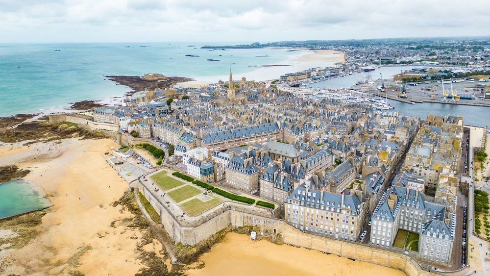
At low tide, the sea retreats several hundred metres from Saint-Malo's ramparts, revealing firm sand where you can walk out to an island that, six hours later, becomes inaccessible again. It is within this rhythm imposed by the ocean that every walk in Saint-Malo takes shape: tide times matter almost as much as a city map. To soak up this corsair city without missing a single story, the Ryo audio-guided tour of Saint-Malo accompanies you step by step around the ramparts, headphones on, at your own pace.
Between the wall walk encircling the intra-muros, the on-foot crossing to Chateaubriand's tomb on Grand Bé, the three kilometres of sea wall stretching towards Paramé, and the rocks hand-carved by a priest who went deaf in Rothéneuf, Saint-Malo packs in walks that have almost nothing in common except the sea. This guide details six routes within the city, the best hikes in the surrounding area (Pointe du Grouin, Cancale, Dinard), where to rent a bike to cover them faster, and above all what time to set off to avoid being cut off by the tide.
Intra-Muros: the Ramparts Walk of Saint-Malo
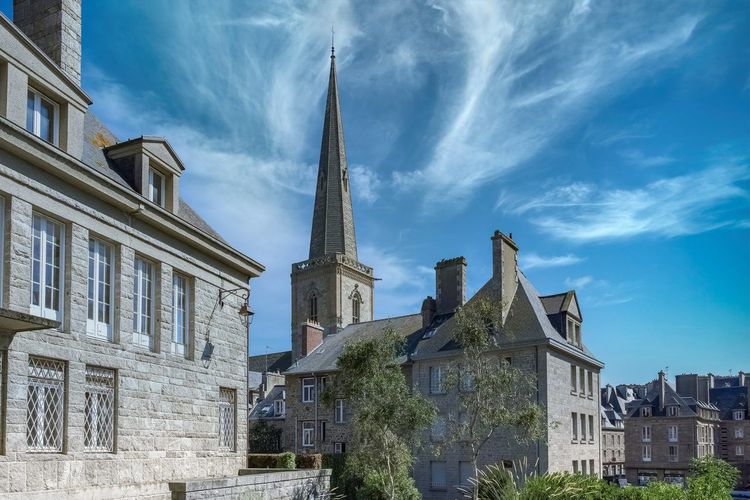
Stepping through Porte Saint-Vincent (Porte Saint-Vincent, 35400 Saint-Malo) at around 8 in the morning, before the tourist coaches arrive, is to discover the intra-muros almost empty, carriage gates ajar onto cobbled courtyards. This gate, the busiest of the nine that pierce the walls, is where most visitors enter the walled city. Just above it, a discreet staircase climbs directly onto the wall walk — the logical starting point for a complete circuit of the ramparts.
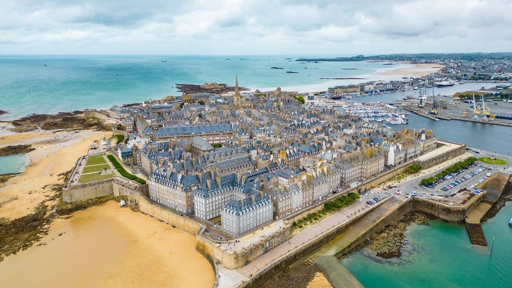
The ramparts you see today do not all date from the same period. The first fortifications go back to the mid-12th century, under Bishop Jean de Châtillon, but most of what you walk along today was modernised from 1691 onwards by Siméon Garangeau, an engineer close to Vauban: between 1708 and 1742, he replaced the old medieval towers, too fragile against cannon fire, with bastions, to protect a city then famous for its privateers. Robert Surcouf and Duguay-Trouin fitted out their ships in this port, bringing back enough Spanish and English plunder to fund a large part of Saint-Malo's urban development. The nickname 'corsair city' comes from that, not from a tourist tagline invented after the fact.
The wall walk measures 1,754 metres, with walls reaching up to 16 metres high in places, and can be walked in its entirety without interruption except at a few gates where you briefly descend into the streets before climbing back up. Allow 1 to 1.5 hours for a complete circuit with regular stops, half that if you walk without pausing. Four points deserve a longer break: the bastion de la Hollande, raised in 1674 on the western side, facing out to sea; the tour Bidouane, to the north-west, a former powder magazine turned observation post; the area around the cathédrale Saint-Vincent, whose spire pierces the sky at the centre of the intra-muros; and above all the sea front, from the tour Bidouane to the porte Saint-Pierre, from where you will see both the Fort National (Fort National, 35400 Saint-Malo, rated 4.5/5 on Google based on 2,474 reviews) perched on its rock and, depending on the tide, Grand Bé accessible or not.
Not all sections are suitable for pushchairs or people with reduced mobility: several staircases punctuate the route, particularly around the tour Bidouane and the porte de Dinan. Families with young children will find it more comfortable to stay on the harbour side, around the porte Saint-Vincent and the Grand'Porte, where the path is wider and less uneven.
The city you are walking through today is not quite the one that existed before the war: in August 1944, the Liberation bombardments destroyed around 80% of the intra-muros. The ramparts themselves largely survived and served as a framework for the reconstruction, stone by stone, during the 1950s under the direction of architect Louis Arretche. Looking at the façades from the wall walk is therefore also to observe one of the most faithful post-war reconstruction projects in France.
The best time for this walk is early morning or late afternoon. In high season, the section overlooking the Plage de Bon Secours fills up quickly, especially at the hours when the low tide draws everyone towards Grand Bé at the same time. In the evening, the raking light over the Rance and the bay more than makes up for the chill that rises from the open sea.
The Ryo audio-guided tour À l'abordage follows this route and extends it: 29 audio tracks, 2h40 and 6.6 km of walking, with at each key stop an anecdote linked to the privateers or the sieges the city endured. It is a way of turning a simple stroll along old stones into a rediscovery of why this city is still fortified, four centuries later.
Grand Bé: the Low-Tide Walk to Chateaubriand's Tomb
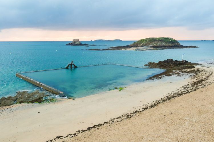
From the Plage de Bon Secours, right at the foot of the ramparts, a raised causeway and then sand lead to Île du Grand Bé (Île du Grand Bé, 35400 Saint-Malo, rated 4.7/5 on Google based on 3K reviews) in about ten minutes on foot. It is here, on a promontory facing west, that François-René de Chateaubriand rests, buried on 18 July 1848. Chateaubriand's tomb is deliberately plain: a simple granite cross, with no name or date, just as the writer had wished ('No inscription, no name, no date — the cross will say that the man lying at its feet was a Christian'). A native of Saint-Malo, he had chosen this rock facing the sea he had described so often; the persistent legend that he is buried standing up is purely local folklore.
The key point before setting out: Grand Bé is only accessible at low tide, within a window of a few hours around low water that varies daily depending on the tidal coefficient. The times are posted at the entrance to the path near the beach and change every day — better to check them the evening before than to rely on a memory of the morning's tide.
Since 2011, a 'bell-ringer of the Bés' warns walkers with a foghorn when the sea begins to come back in — a signal to take very seriously: every year, tourists find themselves stranded on the islet, forced to wait for the next tide or for the rescue services. Allow plenty of time: plan to be back on the sea wall at least 45 minutes before the announced closing time, especially with children who naturally slow down on slippery rocks.
The crossing itself takes 15 to 20 minutes there and back at a leisurely pace, longer if you climb up to explore the island's military remains — fortified from the 16th century, reinforced by Vauban in 1689, and riddled with bunkers during the last war. Wear closed shoes: the ground alternates between compact sand and uneven granite blocks, sometimes wet even when the sea has well and truly retreated.
A little further out, provided the tidal coefficient is high enough, the fort du Petit Bé can be visited on certain days via a paid guided tour, offering a view of the entire bay rarely photographed from the intra-muros. The two islets are easy to tell apart: Grand Bé is the closer and busier one, while Petit Bé, set further out, requires a slightly higher coefficient to reach on foot with dry feet.
In high season, opt for late-morning or afternoon low tides rather than those at dawn: the light is just as beautiful and the crowds on the narrow crossing are noticeably thinner.
The Sillon Sea Wall and Sillon Beach
Leaving the intra-muros through the porte Saint-Vincent, the Sillon sea wall takes over from the ramparts for nearly three kilometres, in an almost straight line between the walled city and the Paramé district. It is the walk most frequented by the locals themselves, from morning joggers to Sunday families.
The Sillon was originally a sand dune ridge connecting the rock of Saint-Malo to the mainland; the masonry sea wall protecting it was built in stages as the seaside resort developed. On the sand, notice the roughly 3,000 oak trunks planted from 1825 onwards: these breakwaters absorb the force of the waves on stormy days and make up one of the most photographed images in the city. Paramé, at the far end of the promenade, remained a separate municipality until it merged with Saint-Malo and Saint-Servan on 26 October 1967.
At the start of the sea wall, the small Plage de l'Éventail also allows you, at low tide, to walk out to Fort National, built by Vauban in 1689 on its rocky islet.
At high tide, Sillon Beach almost disappears entirely under water; at low tide, it stretches for several hundred metres of fine sand, wide enough to host sand yachting on certain windy weekends. It is one of the safest beaches in the city for swimming, supervised in summer, with a gentle slope that reassures families.
On the other side of the intra-muros, at the foot of the western ramparts, the Bon Secours tidal pool (Plage de Bon Secours, 35400 Saint-Malo, rated 4.7/5 on Google based on 140 reviews) is worth a detour before or after the sea wall. This seawater pool designed by architect Yves Hémar in the 1930s is covered at high tide; when the sea retreats, it stays full and you can swim in it facing Grand Bé, in view of the famous white diving board.
The entire length of the sea wall is paved and flat, usable by pushchair, bicycle or rollerblades, making it one of the simplest routes in this guide. For those short on time, the short version of the Ryo audio-guided tour connects the intra-muros to the Sillon without retracing the full ramparts circuit — a practical option for a quick stopover or uncertain weather.
At the far end of the sea wall, on the Paramé side, several café terraces enjoy an open view over the bay, ideal for a break before turning back or continuing towards Rothéneuf. On summer evenings, the Sillon sea wall also offers a fine view of the ramparts' silhouette gilded by the setting sun, without the crowds that pack the wall walk at the same time.
The Cité d'Aleth and Saint-Servan: Between the Tour Solidor and the Fort de la Cité
Many visitors limit their walk in Saint-Malo to the intra-muros and the Sillon, missing a district that actually predates the walled city by several centuries. The Cité d'Aleth, on the Saint-Servan peninsula, corresponds to the original Roman and then medieval settlement: it was here, not on the rock where the intra-muros now stands, that the first town developed, before Bishop Jean de Châtillon transferred the episcopal see to the rock in 1146.
To walk there from the ramparts, allow about 25 to 30 minutes along the harbour, or slightly less by cutting across the quays. The walk first passes through port Solidor, a small wet dock where pleasure yachts and a few traditional sailing vessels are moored, before arriving at the foot of the tour Solidor.
Built between 1369 and 1382 on the orders of Duke Jean IV of Brittany, the tour Solidor is not really a single tower: it consists of three towers side by side, linked by interior staircases, originally designed to monitor the mouth of the Rance and keep a check on Malouin merchants resistant to ducal authority. From 1970 to 2019, it housed the International Museum of Cape Horn Sailors, dedicated to those who rounded Cape Horn under sail. The museum has since closed its doors: you will mainly admire the tower from the quayside, its silhouette reflected at high tide in the Anse Solidor. Check with the tourist office for any occasional opening events.
Continuing towards the tip of the peninsula, the fort de la Cité, also known as the fort d'Alet, occupies the most seaward point. Built on older fortifications, it was heavily concreted by the German army during the Second World War, which turned it into a strongpoint of the Atlantic Wall, complete with bunkers and underground galleries. One blockhouse now houses the Mémorial 39-45, which is only open to visitors during certain periods of the year, but the park and viewpoint remain freely accessible.
Just below, Plage des Sablons (Plage des Sablons, 35400 Saint-Malo, rated 4.4/5 on Google based on 577 reviews) offers a calmer alternative to the Sillon, appreciated by Saint-Servan families who find it less crowded in summer.
Unlike the intra-muros, parking in Saint-Servan remains relatively straightforward even in August, in the neighbourhood streets or around the place Bouvet, a few minutes' walk from the port Solidor. This is worth considering if you want to avoid the paid car parks near the ramparts, which are often full (check local parking rules on the spot, as they change by season).
The district has kept an almost village-like character, with its shipowners' and captains' houses with austere façades, quite different from the rebuilt blocks of the intra-muros. You are more likely to encounter locals walking their dogs than groups of visitors, making it a good option for anyone looking for a walk in Saint-Malo a little away from the summer crowds. It is also along this stretch that the Ryo audio-guided tour explains why the Cité d'Aleth long rivalled the intra-muros before being absorbed into Saint-Malo in 1967.
To explore each of these sites in more depth, two blog articles detail their history: our article on the tour Solidor and our article on the Cité d'Aleth.
Paramé and Rothéneuf: All the Way to the Sculpted Rocks
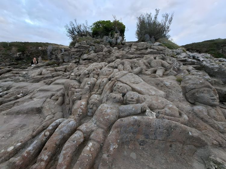
Past the Sillon sea wall, the promenade continues uninterrupted along the Paramé coastline, then through Rothéneuf, a former fishing village long attached to the municipality of Paramé, and therefore to Saint-Malo since 1967. It is also in Rothéneuf that Jacques Cartier owned his manor of Limoëlou, today a museum. Allow around 6 km from the porte Saint-Vincent to reach the sculpted rocks on foot — about an hour and a half of easy walking with the sea almost always in view.
The Paramé district passed through along the way is also worth a glance: its early 20th-century seaside villas, built at a time when the Parisian bourgeoisie was discovering sea bathing, are a reminder that Saint-Malo was not always perceived as a stern fortified city. The Thermes marins spa, set along the sea wall, marks the halfway point of the promenade.
The Rothéneuf promenade itself skirts coves and rocky headlands that are less visited than the Sillon, with several family beaches along the way. Some of these small beaches are only fully revealed at low tide: at high tide, the sea sometimes laps against the promenade's low wall, which does not prevent walking but does reduce the chance of getting down onto the sand.
The attraction that makes the detour worthwhile is the sculpted rocks of Rothéneuf (Chemin des Rochers Sculptés, 35400 Saint-Malo, rated 3.7/5 on Google based on 5,375 reviews): more than 300 figures carved directly into the granite cliff between 1894 and 1907 by Abbé Adolphe Julien Fouéré (1839–1910), a priest who retired to Rothéneuf after a stroke that left him deaf and almost mute. Over thirteen years, he sculpted Breton saints, Jacques Cartier, figures from the news of his day and, according to tradition, the saga of a local family of privateers and smugglers. Originally painted in vivid colours highlighted with tar, the statues have been worn down by sea spray and lichen: the whole thing retains a raw, slightly unsettling quality that sets it apart from the rest of the city's walks.
The site, privately owned and unclassified, charges a modest entrance fee and still welcomes around 40,000 visitors a year. Wear suitable footwear: the sculptures are discovered by picking your way across several levels of rock, sometimes slippery with sea moisture. For visitors who do not want to make the round trip on foot from the intra-muros, several urban bus routes serve Rothéneuf in about fifteen minutes.
On the way to Rothéneuf, the Ryo audio-guided tour tells the story of Abbé Fouéré directly in front of the rocks he carved, with no need to hunt for an information board or guess which legend illustrates which scene. For more detail, our article on the sculpted rocks of Rothéneuf gives the full story of the abbé and his family.
Photographers: aim for late afternoon, when the raking light accentuates the relief of the carvings and softens the sometimes austere look of the grey stone.
The Wreck Promenade: an Unusual Low-Tide Walk
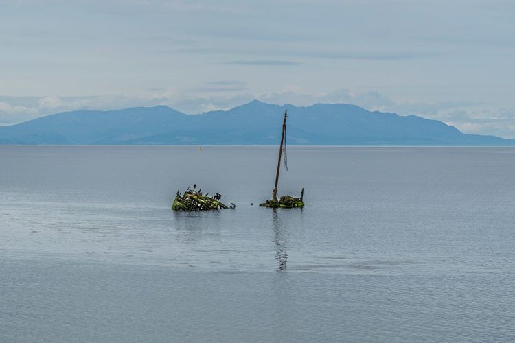
Less well known than the ramparts or Grand Bé, the wreck promenade draws lovers of unusual walks in Saint-Malo. At low tide, several wooden boat carcasses, abandoned on the foreshore of sheltered coves for decades, emerge from the sand and mud — salt-eaten hull skeletons bleached by iodine.
These wrecks are not the result of shipwrecks: they are former fishing or working boats, decommissioned and then deliberately left in the mud, for lack of budget to dismantle them properly. Some still retain the shape of their hull; others are no more than a few frames jutting up towards the sky.
As with Grand Bé, access depends entirely on the tidal coefficient: only a sufficiently low tide exposes enough foreshore to approach the wrecks without sinking into the soft mud that borders some of them. Wear shoes you do not mind getting dirty, and avoid climbing on the more fragile structures, whose timber is rotting from the inside despite still looking solid.
It is a short walk: 20 to 30 minutes is enough to observe several wrecks in succession along the shore, but it feels completely different from the stone scenery of the rest of the city — more mud, seaweed and silence than ramparts and café terraces. Poorly signposted, it is passed on mainly by word of mouth or the recommendations of local photographers in search of a frame different from the usual postcards of the corsair city: ask the tourist office for the exact location of the wrecks visible at the time of your visit, as the foreshore shifts with the storms.
Hikes and Nature Walks Around Saint-Malo: Pointe du Grouin, Cancale, Dinard
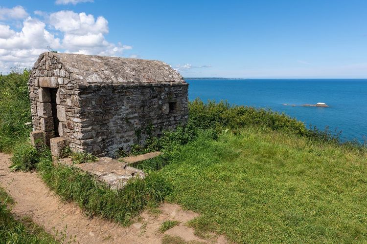
Beyond the urban walks, Saint-Malo also lends itself to longer hikes, carried by the sentier des douaniers (GR34) that runs along virtually the entire Breton coastline. The name comes from the coastguards who once patrolled the shore to track down smugglers. Covering more than 2,000 km across Brittany, the section passing through Saint-Malo remains one of the most frequented, largely because it strings together panoramas without ever straying far from the route. Two directions naturally suggest themselves from the city: eastward, towards Cancale, and westward, on the other side of the Rance estuary, towards Dinard.
To the east, Pointe du Grouin (Pointe du Grouin, 35260 Cancale, rated 4.7/5 on Google based on 2K reviews), about twenty minutes by car from Saint-Malo, offers one of the most spectacular panoramas in the region: a wind-battered rocky headland with views over the Île des Landes, an ornithological reserve closed to the public but visible through binoculars, and on a clear day all the way to Mont-Saint-Michel. The Pointe du Grouin loop marks out a circuit of 6 to 8 km depending on the route chosen, accessible to anyone in reasonable shape, with no technical ascent but sometimes strong winds on the exposed sections. The car parks set back from the headland make the most practical starting point; they fill up quickly at weekends in summer, so it is better to arrive before 10am or plan a late-afternoon hike to enjoy the sunset over the bay.
Between Rothéneuf and Pointe du Grouin, in the commune of Saint-Coulomb, Pointe du Meinga makes a less-visited stop: the second most seaward headland in Ille-et-Vilaine after the Grouin, protected by the Conservatoire du littoral since 1978, it rises to 46 metres and is home to cormorants and oystercatchers. From Pointe du Grouin, the path then descends towards Cancale, the oyster capital: allow around 2 hours of walking to reach the port de la Houle, rewarded on arrival by a platter of oysters eaten on the harbour, with the oyster beds visible at low tide. The path alternates small beaches and exposed rocky headlands: pack water and sunscreen, even for a walk rated easy.
To the west, the boat crossing (vedette) to Dinard takes about ten minutes and opens onto a completely different type of walk: the promenade du Clair de Lune, a seafront path lined with Anglo-Norman seaside villas that have shaped the resort's reputation since the late 19th century. From there, the coastal path continues towards Saint-Briac-sur-Mer, about ten kilometres away, a quieter resort appreciated for its beaches, its golf course and an atmosphere noticeably less fashionable than Dinard.
Further south, heading up the Rance estuary, the village of Saint-Suliac is listed among the most beautiful villages in France: narrow lanes, granite houses packed tightly together, and a viewpoint from the mont Garrot over the meanders of the Rance. Reachable in about thirty minutes by car from Saint-Malo, it can be covered in just under an hour's walk around the village and makes a good stop for anyone wanting to leave the pure coastline and discover the hinterland.
To the west, Dinard, Saint-Briac-sur-Mer and Saint-Suliac fall within the territory of the Parc naturel régional Vallée de la Rance - Côte d'Émeraude, which aims to preserve this landscape of mudflats, coastal heathland and characterful villages stretching between Saint-Malo, Dinard and the Rance valley as far as Dinan. Several waymarked routes laid out by the park allow you to string these walks together over anything from a half-day to several days, depending on your inclination.
For those who want to go further than this summary, our guide to the most beautiful hikes around Saint-Malo and our dedicated article on hiking around Saint-Malo detail complete itineraries, with precise walking times and difficulty levels for each one.
Bike Rental: Exploring Saint-Malo on Two Wheels
To combine several of these walks without spending the entire day on them — particularly to reach Rothéneuf or push on to Dinard along the coastal road — the bicycle remains the most efficient option. Several rental shops operate in the city, offering both standard and electric bikes.
Les Vélos de Babel offer day or half-day rentals. Bik'Inbaie and Cyclerie Bazire round out the offering, including electric bikes that are particularly useful for tackling the few hills around Saint-Servan or Paramé.
Expect to pay roughly between €15 and €25 per day for a standard bike, more for an electric model. Booking the day before in high season avoids nasty surprises: stock runs out fast on fine-weather days.
By bike, the Sillon sea wall and the promenade to Rothéneuf can be covered without any particular effort. On the other hand, it is better to keep walking for the intra-muros: the ramparts cannot be visited by bike, and the cobbled lanes of the walled city would not lend themselves to it anyway. For Pointe du Grouin or Saint-Suliac, further afield, a car or electric bike remain the most realistic options given the distances involved.
Practical Info: Distance, Duration, and Difficulty of Each Walk
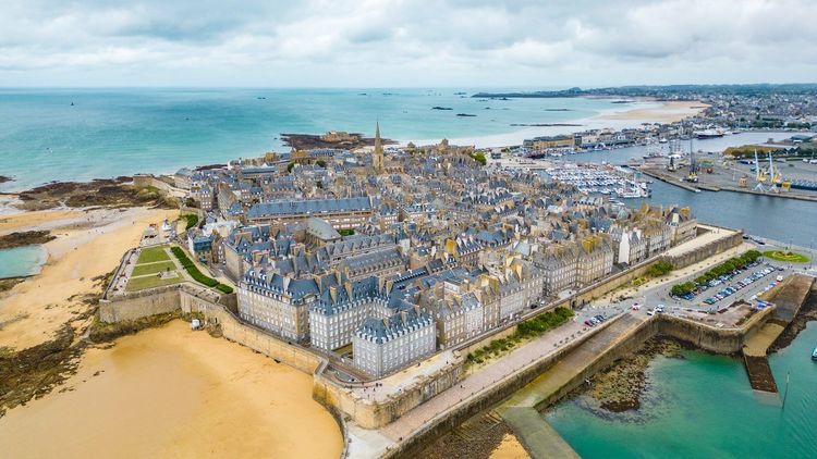
To quickly choose the walk that suits your available time, here is a summary of the distances and durations of the routes described above. The full ramparts circuit covers approximately 1.75 km and takes 1 to 1.5 hours, easy level, accessible to the whole family except for a few occasional steps. The crossing to Grand Bé adds 20 to 30 minutes there and back, easy level but subject to tide schedule constraints. The Sillon sea wall stretches for nearly 3 km in a straight line, walkable in 40 minutes to 1 hour, flat terrain suitable for pushchairs.
Allow more time for the out-of-centre walks: the loop to the Cité d'Aleth and Saint-Servan takes about 1.5 hours there and back from the intra-muros, while the promenade to Rothéneuf and its sculpted rocks totals 2.5 to 3 hours on foot there and back, or just under an hour by bus plus the visit on site. The wreck promenade, being short, can be done in 20 to 30 minutes depending on the number of wrecks visited.
For hikes in the surrounding area, the Pointe du Grouin loop varies from 1.5 to 2.5 hours depending on the route, easy to moderate difficulty with wind. Allow a half-day to combine the Grouin loop with the descent to Cancale, and a full day to take in Dinard, the promenade du Clair de Lune and Saint-Briac-sur-Mer.
In summary: for a morning, prioritise the ramparts and Grand Bé; for a full day, add Rothéneuf or the Cité d'Aleth; for a stay of several days, set aside at least a half-day for the surroundings, either towards Cancale or towards Dinard. On the whole, none of these walks requires hiking gear: good closed shoes and, for Grand Bé or the wrecks, a tolerance for walking on sand and rocks are sufficient. Only the coastal hikes beyond the city, towards Pointe du Grouin or Saint-Suliac, benefit from proper walking shoes if the path is wet.
When to Walk in Saint-Malo: Tides and the Best Season
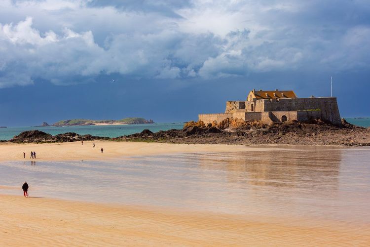
The tide governs a large part of the walks in this guide, and Saint-Malo is not a city like any other in this respect: its tidal range is among the largest in Europe, with a difference that can reach around 13 metres between high and low water during the great equinoctial tides of March and September.
In practice, this means that Grand Bé, the wreck promenade and some of the beaches at Rothéneuf change completely in appearance within a few hours. Before setting off, it is worth consulting the day's tide times, available from the tourist office, on the boards posted near the beaches or via a dedicated app: not just the time of low water, but also the tidal coefficient, which indicates the amplitude of the movement. A high coefficient, above 90, signals a sea that drops far and rises fast — perfect for exploring as much foreshore as possible, but one to respect with a wider safety margin.
As for the season, spring (April–June) and early autumn (September) remain the best periods for walking in Saint-Malo: pleasant temperatures, still-soft light, and visitor numbers well below those of July–August on the ramparts and the Sillon sea wall. Summer is of course still workable, with the advantage of long days that allow several walks to be combined, but plan to head out early to avoid the crowds on the most popular sections.
Winter, less inviting for swimming, paradoxically offers some of the finest walks on the ramparts: clear skies after a storm has passed, a rough sea beating the foot of the fortifications, and an intra-muros almost empty on weekdays.




FAQ
What is the most beautiful place to visit in Saint-Malo?
Hard to choose, but the sea-facing stretch of the ramparts between the tour Bidouane and the porte Saint-Pierre packs the most viewpoints into a short distance: the bay, Grand Bé depending on the tide, and the intra-muros rebuilt after the war. At low tide, the walk out to Chateaubriand's tomb remains the most memorable experience for many visitors.
How long does it take to walk the full circuit of Saint-Malo's ramparts?
Allow 1 to 1.5 hours for a complete circuit of the 1.75 km wall walk with regular stops at viewpoints, or 40 minutes if you walk without pausing.
Can you visit Grand Bé at any time?
No: the island is only accessible on foot for a few hours around low tide, as the crossing is submerged the rest of the time. The schedule changes daily depending on the tidal coefficient and is posted near the Plage de Bon Secours. In season, a bell-ringer equipped with a foghorn warns walkers when the sea starts to come back in.
What is the best walk to do in Saint-Malo?
For a first visit, the ramparts circuit combined with the low-tide crossing to Grand Bé makes the most complete half-day combination. For something off the beaten track, the walk out to the sculpted rocks of Rothéneuf or the wreck promenade offer a more unusual experience, and are less crowded in high season.
Where can you park to explore Saint-Malo on foot?
The car parks at the foot of the ramparts, such as the one at the esplanade Saint-Vincent, fill up quickly in summer and charge a fee. In high season, the Park & Ride at Paul Féval, connected to the centre by shuttle, saves you circling in search of a space. In Saint-Servan, parking is easier to find, about a twenty-minute walk from the intra-muros via the port Solidor.
Is Saint-Malo a good city for family walks?
Yes: the Sillon sea wall, flat and paved for nearly three kilometres, is well suited to pushchairs, and the ramparts circuit is accessible to children who can already walk independently. Only certain sections of the wall walk involve steps, and the crossing to Grand Bé requires keeping a close eye on younger children on the rocks.
What is the best time to walk in Saint-Malo given the tides and the season?
Spring and early autumn offer the best balance between pleasant weather and lower crowds. For tide-dependent walks — Grand Bé and the wreck promenade in particular — aim for a coefficient above roughly 70 to expose as much foreshore as possible, and check the day's schedule before you set off rather than relying on an average.
In Summary: Which Walk to Choose in Saint-Malo
Saint-Malo is hard to take in on a single walk. Between the ramparts circuit, the tide-governed crossing to Grand Bé, the Sillon sea wall and the more off-the-beaten-path detour via Rothéneuf or the Cité d'Aleth, each route tells a different facet of the city: corsair, literary, seaside or simply local. The common thread remains the sea, which sets the pace for almost all of these itineraries.
For a first visit, it is better not to try to do everything on the same day: the ramparts and Grand Bé are more than enough to fill a morning, leaving the afternoon free for the Sillon sea wall or a trip to Saint-Servan. If time allows, keep at least a half-day for leaving the city, either towards Pointe du Grouin or towards Dinard. To make sure you do not miss the stories that give all these stones their meaning, the Ryo audio-guided tour of Saint-Malo remains the simplest way to turn a stroll into a real discovery, at your own pace.
À lire également